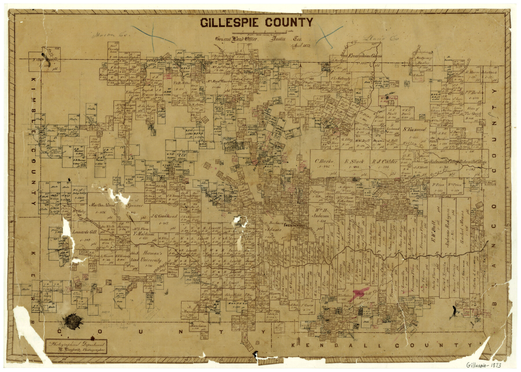
Gillespie County
-
Map/Doc
3580
-
Collection
General Map Collection
-
Object Dates
1873 (Creation Date)
-
People and Organizations
Texas General Land Office (Publisher)
Herman Lungkwitz (Draftsman)
-
Counties
Gillespie
-
Subjects
County
-
Height x Width
16.0 x 22.4 inches
40.6 x 56.9 cm
-
Features
Cypress Creek
Live Oak Creek
Baron's Creek
Fredericksburg
Palo Alto Creek
South Grape Creek
Bear Creek
Wolf Creek
Kerrville Road
Delaware Creek
Spring Creek
Squaw Creek
Pinto Trail
Mason to Kerville [Road]
Mason Road
Kerville Road
Fall Creek
Hell Creek
Mount Hudson
Legion Creek
Threadgill's Creek
Salt Creek
Onion Creek
Walnut Creek
Edward's Creek
Fort Mason Road
Sandy Creek
Crab Apple Creek
Mesquite Creek
Coal Creek
Enchanted Rock
Mount Nibo
Willow Creek
North Grape Creek
Pedernales River
Flag Creek
White Oak Creek
Part of: General Map Collection
Kenedy County Rolled Sketch 13

Print $20.00
- Digital $50.00
Kenedy County Rolled Sketch 13
1946
Size 38.2 x 45.5 inches
Map/Doc 9334
Right of Way and Track Map, the Missouri, Kansas & Texas Ry. Of Texas operated by the Missouri, Kansas & Texas Ry. Of Texas, Houston Division

Print $40.00
- Digital $50.00
Right of Way and Track Map, the Missouri, Kansas & Texas Ry. Of Texas operated by the Missouri, Kansas & Texas Ry. Of Texas, Houston Division
1918
Size 26.0 x 62.1 inches
Map/Doc 64785
Map of Comanche County

Print $40.00
- Digital $50.00
Map of Comanche County
1895
Size 47.5 x 50.0 inches
Map/Doc 4735
Blanco County Working Sketch 2

Print $20.00
- Digital $50.00
Blanco County Working Sketch 2
Size 26.6 x 20.5 inches
Map/Doc 67361
Bexar County Sketch File 9

Print $4.00
- Digital $50.00
Bexar County Sketch File 9
1853
Size 8.2 x 13.2 inches
Map/Doc 14479
Hudspeth County Working Sketch 20

Print $40.00
- Digital $50.00
Hudspeth County Working Sketch 20
1966
Size 43.8 x 63.6 inches
Map/Doc 66302
[G.C. and S. F. R.R. Co. Through Bosque County from McLennan Co. and E. to Hill Co. Station M. P. 259 to M. P. 297]
![64564, [G.C. and S. F. R.R. Co. Through Bosque County from McLennan Co. and E. to Hill Co. Station M. P. 259 to M. P. 297], General Map Collection](https://historictexasmaps.com/wmedia_w700/maps/64564-1.tif.jpg)
Print $40.00
- Digital $50.00
[G.C. and S. F. R.R. Co. Through Bosque County from McLennan Co. and E. to Hill Co. Station M. P. 259 to M. P. 297]
1898
Size 22.4 x 101.5 inches
Map/Doc 64564
Presidio County Boundary File 1a

Print $80.00
- Digital $50.00
Presidio County Boundary File 1a
Size 50.2 x 14.9 inches
Map/Doc 58052
Cochran County

Print $20.00
- Digital $50.00
Cochran County
1899
Size 40.9 x 32.6 inches
Map/Doc 4744
Sabine River, Composite Sheet

Print $40.00
- Digital $50.00
Sabine River, Composite Sheet
Size 38.5 x 52.7 inches
Map/Doc 65133
Houston Ship Channel, Alexander Island to Carpenter Bayou

Print $20.00
- Digital $50.00
Houston Ship Channel, Alexander Island to Carpenter Bayou
1975
Size 35.1 x 46.6 inches
Map/Doc 69911
Flight Mission No. CGI-3N, Frame 129, Cameron County

Print $20.00
- Digital $50.00
Flight Mission No. CGI-3N, Frame 129, Cameron County
1954
Size 18.5 x 22.2 inches
Map/Doc 84602
You may also like
PSL Field Notes for Block B13 in Crane, Ector, Ward, and Winkler Counties, Blocks B14 and B16 in Crane and Ector Counties, Blocks B7 and B8 in Ector and Winkler Counties and Block B15 in Ector County

PSL Field Notes for Block B13 in Crane, Ector, Ward, and Winkler Counties, Blocks B14 and B16 in Crane and Ector Counties, Blocks B7 and B8 in Ector and Winkler Counties and Block B15 in Ector County
Map/Doc 81651
[Missouri, Kansas & Texas Line Map through Bastrop County]
![64029, [Missouri, Kansas & Texas Line Map through Bastrop County], General Map Collection](https://historictexasmaps.com/wmedia_w700/maps/64029.tif.jpg)
Print $40.00
- Digital $50.00
[Missouri, Kansas & Texas Line Map through Bastrop County]
1916
Size 25.8 x 122.6 inches
Map/Doc 64029
[Part of Blocks H. & G. N. 12, University Lands 16 and 17, C-3, C-4, A-2, 194 and Z]
![91621, [Part of Blocks H. & G. N. 12, University Lands 16 and 17, C-3, C-4, A-2, 194 and Z], Twichell Survey Records](https://historictexasmaps.com/wmedia_w700/maps/91621-1.tif.jpg)
Print $20.00
- Digital $50.00
[Part of Blocks H. & G. N. 12, University Lands 16 and 17, C-3, C-4, A-2, 194 and Z]
1907
Size 26.1 x 18.9 inches
Map/Doc 91621
Reconnoissances of Routes from San Antonio de Bexar, El Paso del Norte &c &c

Print $20.00
- Digital $50.00
Reconnoissances of Routes from San Antonio de Bexar, El Paso del Norte &c &c
1849
Size 26.3 x 38.9 inches
Map/Doc 94853
The Villa and Presidio of San Antonio de Bexar

The Villa and Presidio of San Antonio de Bexar
1935
Size 18.1 x 23.6 inches
Map/Doc 93564
History Salvaged from the Sea

History Salvaged from the Sea
1977
Size 23.0 x 30.4 inches
Map/Doc 96836
Upton County Rolled Sketch 41

Print $20.00
- Digital $50.00
Upton County Rolled Sketch 41
Size 27.4 x 40.8 inches
Map/Doc 8080
Shelby County, Texas

Print $40.00
- Digital $50.00
Shelby County, Texas
1897
Size 40.0 x 48.3 inches
Map/Doc 63032
[Texas & Pacific Railway through Callahan County]
![64231, [Texas & Pacific Railway through Callahan County], General Map Collection](https://historictexasmaps.com/wmedia_w700/maps/64231.tif.jpg)
Print $20.00
- Digital $50.00
[Texas & Pacific Railway through Callahan County]
1918
Size 21.2 x 9.5 inches
Map/Doc 64231
Jack County Sketch File 9a

Print $6.00
- Digital $50.00
Jack County Sketch File 9a
1857
Size 12.5 x 7.8 inches
Map/Doc 27522
Garza County Sketch File J

Print $20.00
- Digital $50.00
Garza County Sketch File J
1911
Size 26.5 x 7.5 inches
Map/Doc 11555
Jesse Devore League

Print $20.00
- Digital $50.00
Jesse Devore League
1919
Size 45.6 x 37.4 inches
Map/Doc 65460