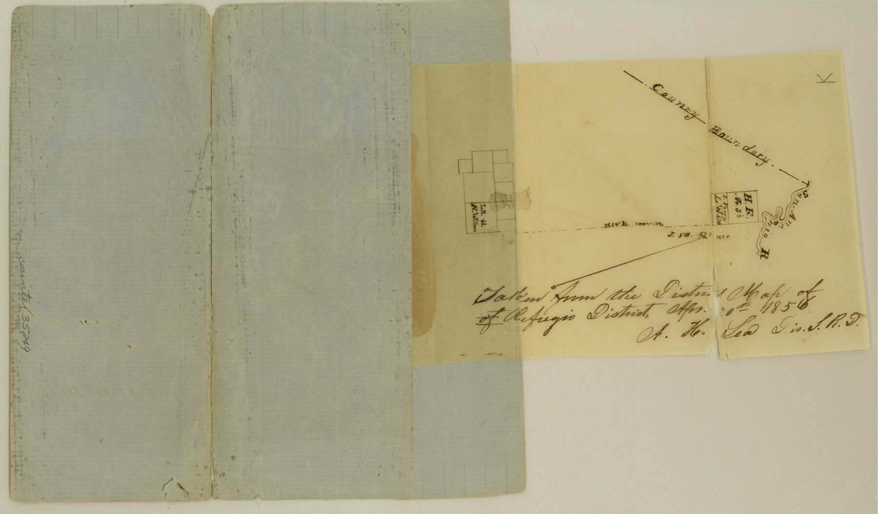
Refugio County Sketch File 6
[Sketch of area in the north corner of Refugio County near the San Antonio River]
- 
                          Map/Doc35249
- 
                            CollectionGeneral Map Collection
- 
                            Object Dates4/20/1856 (Creation Date)
- 
                            People and OrganizationsA.H. Lea (Surveyor/Engineer)
- 
                            CountiesRefugio
- 
                            SubjectsSurveying Sketch File
- 
                            Height x Width8.0 x 13.7 inches20.3 x 34.8 cm
- 
                            Mediumpaper, manuscript
- 
                            FeaturesSan Antonio River
Part of: General Map Collection
            Atascosa County Rolled Sketch 20A


                                            Print $20.00                    
                                             -                         Digital $50.00                                    
                Atascosa County Rolled Sketch 20A
Size 41.8 x 32.8 inches
                                Map/Doc 10224
            
            Parker County Working Sketch 20


                                            Print $20.00                    
                                             -                         Digital $50.00                                    
                Parker County Working Sketch 20
2005
Map/Doc 83581
            
            Fayette County Boundary File 4


                                            Print $19.00                    
                                             -                         Digital $50.00                                    
                Fayette County Boundary File 4
Size 14.4 x 9.0 inches
                                Map/Doc 53362
            
            [Surveys near the Medina River, Bexar District]
            
                                    ![230, [Surveys near the Medina River, Bexar District], General Map Collection](https://historictexasmaps.com/wmedia_w700/maps/230.tif.jpg) 


    ![230, [Surveys near the Medina River, Bexar District], General Map Collection](https://historictexasmaps.com/wmedia_w700/maps/230.tif.jpg) 
                                
            
                                            Print $2.00                    
                                             -                         Digital $50.00                                    
                [Surveys near the Medina River, Bexar District]
1847
Size 13.1 x 8.0 inches
                                Map/Doc 230
            
            Portion of States Submerged Area in Matagorda Bay


                                            Print $20.00                    
                                             -                         Digital $50.00                                    
                Portion of States Submerged Area in Matagorda Bay
1922
Size 14.0 x 12.5 inches
                                Map/Doc 2955
            
            Nueces Bay and Adjoining Areas showing submerged Lands


                                            Print $40.00                    
                                             -                         Digital $50.00                                    
                Nueces Bay and Adjoining Areas showing submerged Lands
1946
Size 34.6 x 56.4 inches
                                Map/Doc 1916
            
            Cooke County Sketch File 11


                                            Print $4.00                    
                                             -                         Digital $50.00                                    
                Cooke County Sketch File 11
1858
Size 12.4 x 8.2 inches
                                Map/Doc 19244
            
            Crane County Rolled Sketch 2


                                            Print $40.00                    
                                             -                         Digital $50.00                                    
                Crane County Rolled Sketch 2
1888
Size 55.3 x 29.0 inches
                                Map/Doc 8676
            
            Pecos County Sketch File 88


                                            Print $6.00                    
                                             -                         Digital $50.00                                    
                Pecos County Sketch File 88
1934
Size 17.0 x 11.0 inches
                                Map/Doc 33984
            
            Sketch of the route taken by a scouting party from Phantom Hill to Double Mountain, Texas


                                            Print $20.00                    
                                             -                         Digital $50.00                                    
                Sketch of the route taken by a scouting party from Phantom Hill to Double Mountain, Texas
1852
Size 25.3 x 13.4 inches
                                Map/Doc 2006
            
            Webb County Sketch File 25


                                            Print $20.00                    
                                             -                         Digital $50.00                                    
                Webb County Sketch File 25
1936
Size 18.2 x 30.7 inches
                                Map/Doc 12639
            You may also like
            Key to Photo Index Sheets of Texas Coast Portion


                                            Print $20.00                    
                                             -                         Digital $50.00                                    
                Key to Photo Index Sheets of Texas Coast Portion
1954
Size 20.0 x 24.0 inches
                                Map/Doc 83437
            
            Real County Working Sketch 11


                                            Print $20.00                    
                                             -                         Digital $50.00                                    
                Real County Working Sketch 11
1929
Size 25.8 x 35.6 inches
                                Map/Doc 71903
            
            Liberty County Sketch File 65


                                            Print $4.00                    
                                             -                         Digital $50.00                                    
                Liberty County Sketch File 65
1895
Size 11.0 x 8.7 inches
                                Map/Doc 30128
            
            Nueces County Sketch File 49


                                            Print $20.00                    
                                             -                         Digital $50.00                                    
                Nueces County Sketch File 49
1956
Size 32.4 x 17.1 inches
                                Map/Doc 42193
            
            Dallas County Boundary File 6a


                                            Print $36.00                    
                                             -                         Digital $50.00                                    
                Dallas County Boundary File 6a
Size 14.0 x 8.6 inches
                                Map/Doc 52189
            
            Crockett County Working Sketch 2


                                            Print $20.00                    
                                             -                         Digital $50.00                                    
                Crockett County Working Sketch 2
Size 18.4 x 14.9 inches
                                Map/Doc 68335
            
            Hardin County Working Sketch 16


                                            Print $20.00                    
                                             -                         Digital $50.00                                    
                Hardin County Working Sketch 16
1940
Size 18.1 x 23.2 inches
                                Map/Doc 63414
            
            Brooks County Rolled Sketch 15


                                            Print $20.00                    
                                             -                         Digital $50.00                                    
                Brooks County Rolled Sketch 15
1931
Size 22.4 x 36.8 inches
                                Map/Doc 5340
            
            Austin, Texas Congress Ave. Drainage


                                            Print $20.00                    
                                             -                         Digital $50.00                                    
                Austin, Texas Congress Ave. Drainage
1903
Size 15.1 x 15.5 inches
                                Map/Doc 75797
            
            Kimble County Working Sketch 27


                                            Print $20.00                    
                                             -                         Digital $50.00                                    
                Kimble County Working Sketch 27
1934
Size 16.1 x 17.3 inches
                                Map/Doc 70095
            
            Tyler County Sketch File 11


                                            Print $4.00                    
                                             -                         Digital $50.00                                    
                Tyler County Sketch File 11
1849
Size 11.3 x 5.6 inches
                                Map/Doc 38650
            
            Map of Dallas, Tarrant and part of Ellis County and Peters Colony


                                            Print $20.00                    
                                             -                         Digital $50.00                                    
                Map of Dallas, Tarrant and part of Ellis County and Peters Colony
1853
Size 25.8 x 32.0 inches
                                Map/Doc 1970
             
                            