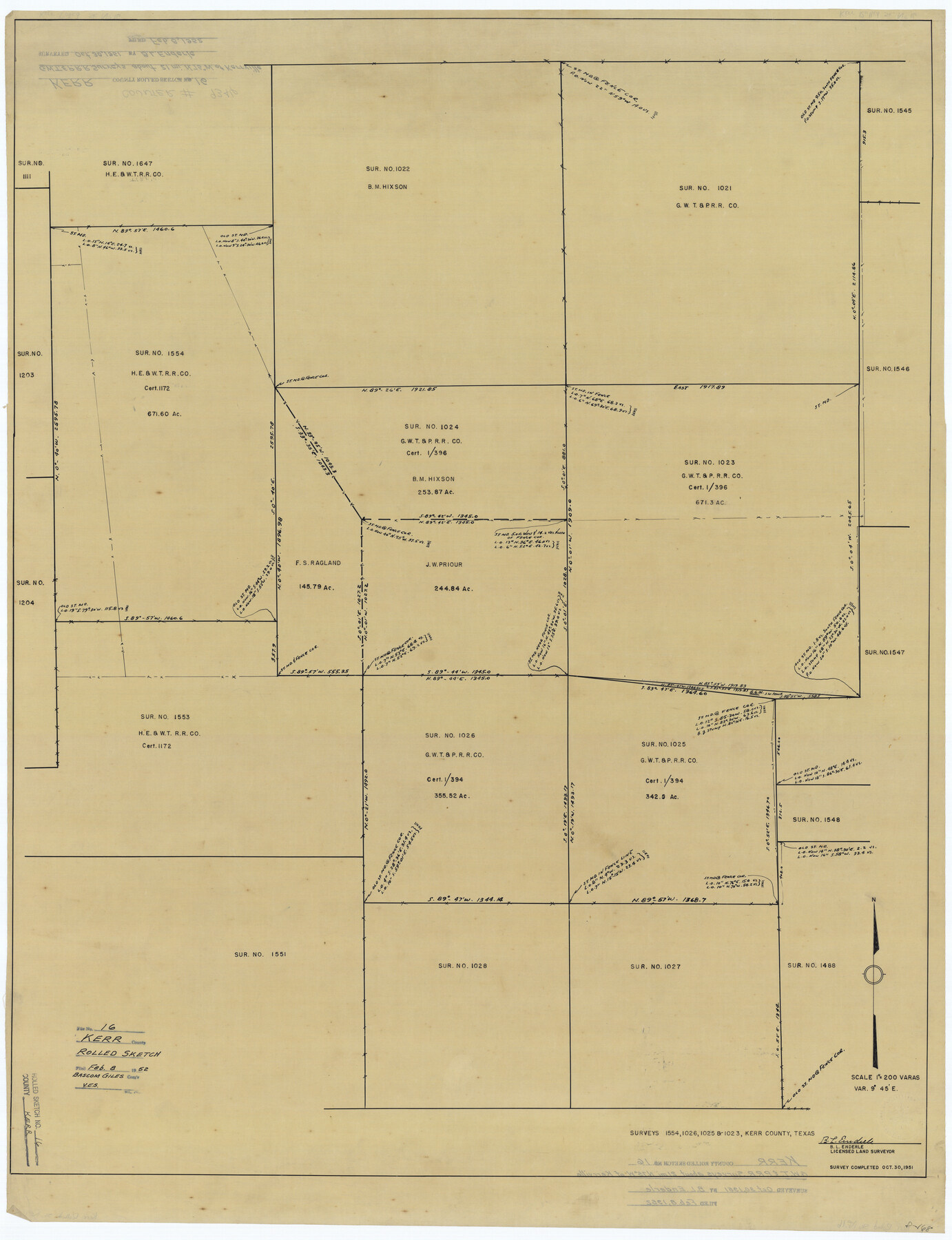
Kerr County Rolled Sketch 16
Surveys 1554, 1026, 1025, & 1023, Kerr County, Texas
-
Map/Doc
9346
-
Collection
General Map Collection
-
Object Dates
1951/10/30 (Creation Date)
1952/2/8 (File Date)
-
People and Organizations
B.L. Enderle (Surveyor/Engineer)
-
Counties
Kerr
-
Subjects
Surveying Rolled Sketch
-
Height x Width
40.6 x 31.1 inches
103.1 x 79.0 cm
-
Medium
van dyke/brownline/sepia
-
Scale
1" = 200 varas
Part of: General Map Collection
Flight Mission No. DQN-2K, Frame 195, Calhoun County

Print $20.00
- Digital $50.00
Flight Mission No. DQN-2K, Frame 195, Calhoun County
1953
Size 18.6 x 22.2 inches
Map/Doc 84333
Clay County Sketch File 11a

Print $22.00
- Digital $50.00
Clay County Sketch File 11a
1861
Size 18.3 x 11.9 inches
Map/Doc 11084
Somervell County Working Sketch 5

Print $20.00
- Digital $50.00
Somervell County Working Sketch 5
1975
Size 33.3 x 39.4 inches
Map/Doc 63909
Flight Mission No. DIX-10P, Frame 150, Aransas County

Print $20.00
- Digital $50.00
Flight Mission No. DIX-10P, Frame 150, Aransas County
1956
Size 18.7 x 22.3 inches
Map/Doc 83952
Val Verde County Sketch File A1

Print $6.00
- Digital $50.00
Val Verde County Sketch File A1
1895
Size 14.4 x 9.2 inches
Map/Doc 39038
Presidio County Rolled Sketch 22A

Print $20.00
- Digital $50.00
Presidio County Rolled Sketch 22A
1909
Size 20.6 x 31.9 inches
Map/Doc 7332
Nueces County Rolled Sketch 54

Print $67.00
- Digital $50.00
Nueces County Rolled Sketch 54
1978
Size 9.8 x 15.0 inches
Map/Doc 47875
Limestone County Working Sketch Graphic Index

Print $20.00
- Digital $50.00
Limestone County Working Sketch Graphic Index
1971
Size 47.8 x 32.9 inches
Map/Doc 76621
Galveston County NRC Article 33.136 Sketch 74

Print $26.00
- Digital $50.00
Galveston County NRC Article 33.136 Sketch 74
2013
Size 24.0 x 36.0 inches
Map/Doc 95114
Chambers County Working Sketch 13

Print $20.00
- Digital $50.00
Chambers County Working Sketch 13
1956
Size 30.1 x 24.6 inches
Map/Doc 67996
Young County Boundary File 1

Print $8.00
- Digital $50.00
Young County Boundary File 1
Size 10.3 x 8.2 inches
Map/Doc 60198
Township No. 2 South Range No. 24 West of the Indian Meridian

Print $20.00
- Digital $50.00
Township No. 2 South Range No. 24 West of the Indian Meridian
1875
Size 19.3 x 24.4 inches
Map/Doc 75174
You may also like
Childress Co.

Print $20.00
- Digital $50.00
Childress Co.
1892
Size 40.3 x 33.7 inches
Map/Doc 66752
El Paso County Working Sketch 8

Print $20.00
- Digital $50.00
El Paso County Working Sketch 8
1952
Size 23.9 x 22.5 inches
Map/Doc 69030
Guadalupe County Sketch File 1a

Print $4.00
- Digital $50.00
Guadalupe County Sketch File 1a
1859
Size 12.6 x 7.9 inches
Map/Doc 24646
Fisher County

Print $20.00
- Digital $50.00
Fisher County
1880
Size 29.4 x 25.3 inches
Map/Doc 75772
[PSL Block 1 along State line]
![90579, [PSL Block 1 along State line], Twichell Survey Records](https://historictexasmaps.com/wmedia_w700/maps/90579-1.tif.jpg)
Print $2.00
- Digital $50.00
[PSL Block 1 along State line]
Size 14.1 x 8.0 inches
Map/Doc 90579
Dickens County Rolled Sketch 12

Print $20.00
- Digital $50.00
Dickens County Rolled Sketch 12
1959
Size 33.5 x 39.7 inches
Map/Doc 8790
Terry County Sketch File 11

Print $20.00
- Digital $50.00
Terry County Sketch File 11
Size 10.9 x 43.2 inches
Map/Doc 10395
Hockley County Sketch File 16

Print $20.00
- Digital $50.00
Hockley County Sketch File 16
Size 23.6 x 30.9 inches
Map/Doc 11774
Jasper County Sketch File 10

Print $4.00
- Digital $50.00
Jasper County Sketch File 10
1878
Size 9.1 x 8.6 inches
Map/Doc 27788
Township 14 South Range 15 West of the Louisiana Meridian, Louisiana

Print $20.00
- Digital $50.00
Township 14 South Range 15 West of the Louisiana Meridian, Louisiana
1875
Size 19.6 x 24.6 inches
Map/Doc 65859
Smith County Sketch File 3

Print $4.00
- Digital $50.00
Smith County Sketch File 3
1853
Size 10.5 x 8.6 inches
Map/Doc 36750
[T. & P. RR. Co. Blocks 31-36, Townships 3N, 4N and 5N and surrounding area]
![93135, [T. & P. RR. Co. Blocks 31-36, Townships 3N, 4N and 5N and surrounding area], Twichell Survey Records](https://historictexasmaps.com/wmedia_w700/maps/93135-1.tif.jpg)
Print $40.00
- Digital $50.00
[T. & P. RR. Co. Blocks 31-36, Townships 3N, 4N and 5N and surrounding area]
Size 51.3 x 51.5 inches
Map/Doc 93135