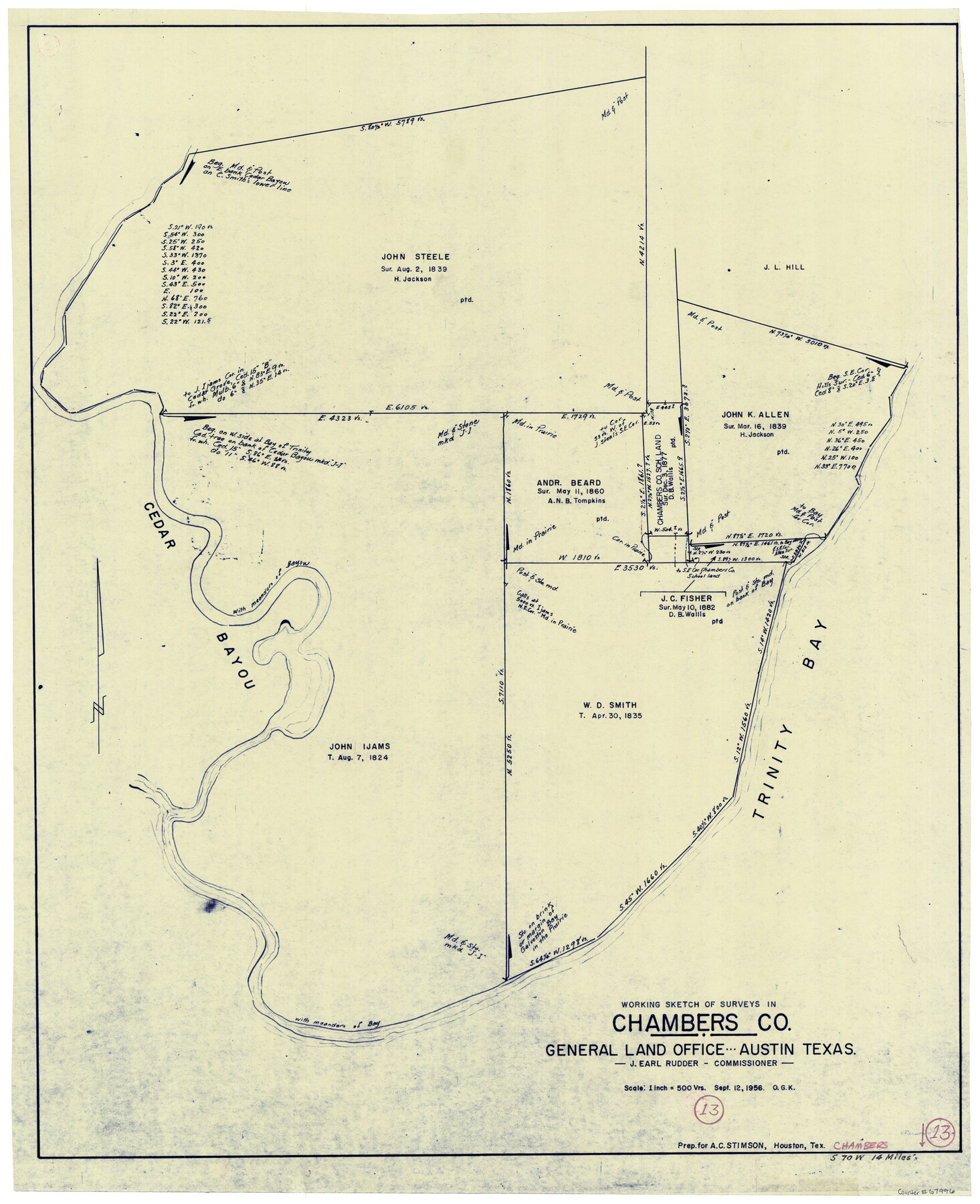
Chambers County Working Sketch 13
-
Map/Doc
67996
-
Collection
General Map Collection
-
Object Dates
9/12/1956 (Creation Date)
-
People and Organizations
Otto G. Kurio (Draftsman)
-
Counties
Chambers
-
Subjects
Surveying Working Sketch
-
Height x Width
30.1 x 24.6 inches
76.5 x 62.5 cm
-
Scale
1" = 500 varas
Part of: General Map Collection
Hartley County Boundary File 2

Print $52.00
- Digital $50.00
Hartley County Boundary File 2
Size 8.8 x 24.8 inches
Map/Doc 54453
Hutchinson County Rolled Sketch 40

Print $20.00
- Digital $50.00
Hutchinson County Rolled Sketch 40
1981
Size 26.0 x 37.5 inches
Map/Doc 6302
Map of Houston Heights, Harris County, Texas owned by the Omaha & South Texas Land Co., Houston, Texas

Print $20.00
- Digital $50.00
Map of Houston Heights, Harris County, Texas owned by the Omaha & South Texas Land Co., Houston, Texas
1891
Size 16.3 x 10.7 inches
Map/Doc 94458
Duval County Rolled Sketch 23

Print $20.00
- Digital $50.00
Duval County Rolled Sketch 23
1943
Size 23.0 x 20.9 inches
Map/Doc 5742
Sutton County Working Sketch 13

Print $40.00
- Digital $50.00
Sutton County Working Sketch 13
1972
Size 58.8 x 37.0 inches
Map/Doc 62356
Map of Nacogdoches County

Print $20.00
- Digital $50.00
Map of Nacogdoches County
1881
Size 24.0 x 21.3 inches
Map/Doc 4602
Jasper County Rolled Sketch 7B

Print $20.00
- Digital $50.00
Jasper County Rolled Sketch 7B
Size 19.7 x 11.6 inches
Map/Doc 6355
Brewster County Rolled Sketch 147

Print $20.00
- Digital $50.00
Brewster County Rolled Sketch 147
1986
Size 24.6 x 24.8 inches
Map/Doc 5313
Flight Mission No. CLL-1N, Frame 109, Willacy County

Print $20.00
- Digital $50.00
Flight Mission No. CLL-1N, Frame 109, Willacy County
1954
Size 18.3 x 22.1 inches
Map/Doc 87043
Aransas County Rolled Sketch 19A

Print $20.00
- Digital $50.00
Aransas County Rolled Sketch 19A
1979
Size 32.0 x 24.8 inches
Map/Doc 76068
Knox County Boundary File 6

Print $4.00
- Digital $50.00
Knox County Boundary File 6
Size 11.4 x 8.7 inches
Map/Doc 65049
Roberts County Rolled Sketch 3

Print $40.00
- Digital $50.00
Roberts County Rolled Sketch 3
Size 38.0 x 49.7 inches
Map/Doc 8355
You may also like
Map of Comal County

Print $20.00
- Digital $50.00
Map of Comal County
1879
Size 19.3 x 25.7 inches
Map/Doc 4521
Palo Pinto County Sketch File 29

Print $40.00
- Digital $50.00
Palo Pinto County Sketch File 29
1874
Size 12.8 x 16.0 inches
Map/Doc 33419
Sterling County Sketch File 24

Print $6.00
- Digital $50.00
Sterling County Sketch File 24
1955
Size 11.1 x 8.5 inches
Map/Doc 37189
Tarrant County

Print $20.00
- Digital $50.00
Tarrant County
1873
Size 18.6 x 17.4 inches
Map/Doc 4631
Shackelford County Rolled Sketch 5

Print $20.00
- Digital $50.00
Shackelford County Rolled Sketch 5
1984
Size 23.1 x 37.1 inches
Map/Doc 7773
Wise County Working Sketch 27

Print $20.00
- Digital $50.00
Wise County Working Sketch 27
1988
Size 28.0 x 37.2 inches
Map/Doc 72641
Plat Showing Survey made for J. M. Teague, Jr. Gaines County, Texas

Print $20.00
- Digital $50.00
Plat Showing Survey made for J. M. Teague, Jr. Gaines County, Texas
1956
Size 12.7 x 18.7 inches
Map/Doc 92672
Yoakum County Sketch File 11

Print $4.00
- Digital $50.00
Yoakum County Sketch File 11
1914
Size 11.3 x 8.9 inches
Map/Doc 40763

Real County Sketch File 6

Print $20.00
- Digital $50.00
Real County Sketch File 6
1931
Size 17.3 x 19.6 inches
Map/Doc 12229
Map of Liberty County

Print $40.00
- Digital $50.00
Map of Liberty County
1903
Size 54.9 x 53.6 inches
Map/Doc 16878
Map of Wharton County

Print $40.00
- Digital $50.00
Map of Wharton County
1895
Size 48.2 x 53.8 inches
Map/Doc 82055