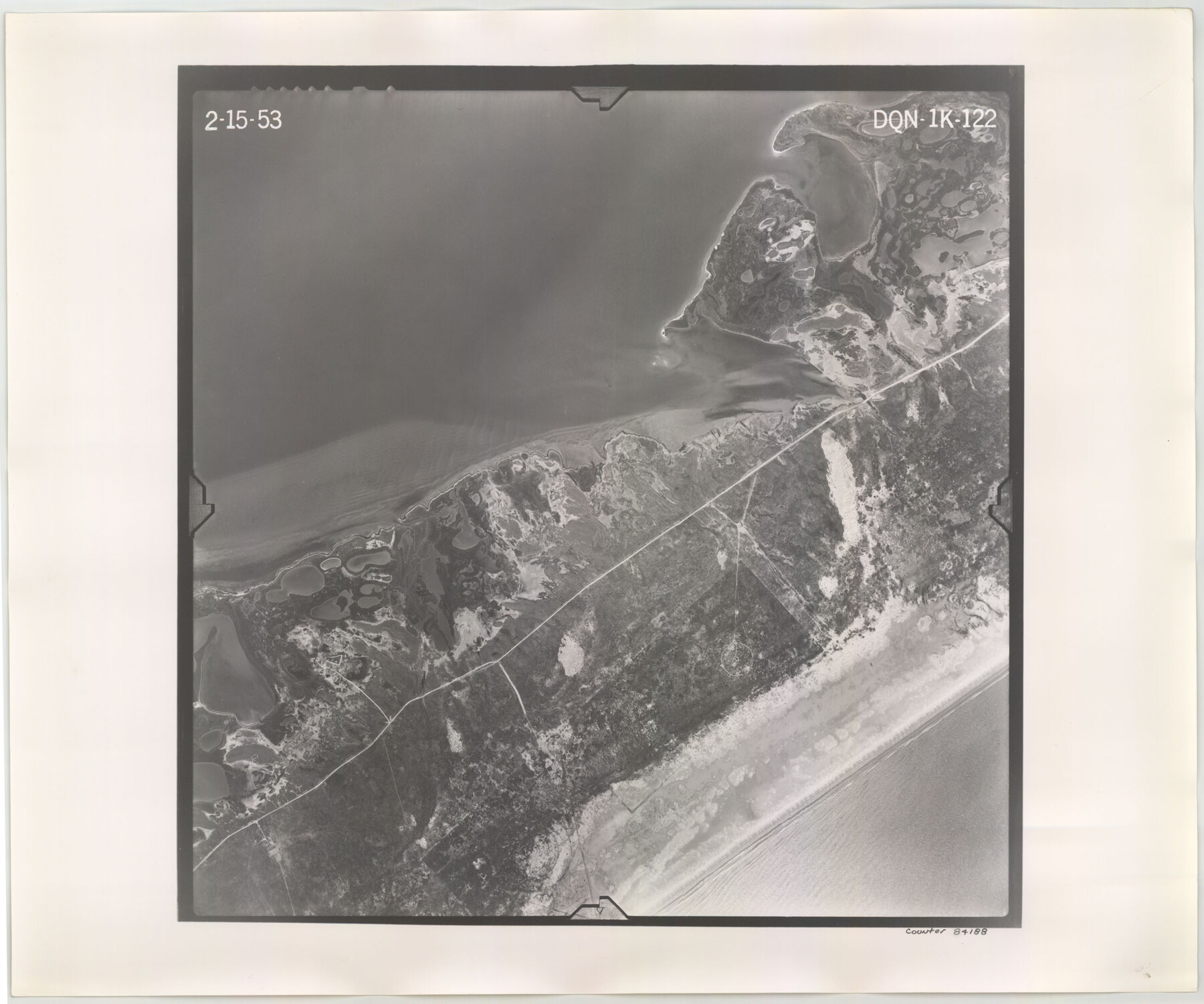
Flight Mission No. DQN-1K, Frame 122, Calhoun County
DQN-1K-122
-
Map/Doc
84188
-
Collection
General Map Collection
-
Object Dates
1953/2/15 (Creation Date)
-
People and Organizations
U. S. Department of Agriculture (Publisher)
-
Counties
Calhoun
-
Subjects
Aerial Photograph
-
Height x Width
18.5 x 22.2 inches
47.0 x 56.4 cm
-
Comments
Flown by Aero Exploration Company of Tulsa, Oklahoma.
Part of: General Map Collection
Lavaca County Sketch File 4

Print $6.00
- Digital $50.00
Lavaca County Sketch File 4
Size 8.2 x 15.3 inches
Map/Doc 29636
Uvalde County Rolled Sketch 15

Print $20.00
- Digital $50.00
Uvalde County Rolled Sketch 15
1979
Size 26.9 x 23.9 inches
Map/Doc 8099
Map of Texas Gulf Coast and Texas Continental Shelf showing Natural Gas Pipe Lines

Print $40.00
- Digital $50.00
Map of Texas Gulf Coast and Texas Continental Shelf showing Natural Gas Pipe Lines
1966
Size 39.6 x 57.0 inches
Map/Doc 75902
Topographical Map of the Rio Grande, Sheet No. 20

Print $20.00
- Digital $50.00
Topographical Map of the Rio Grande, Sheet No. 20
1912
Map/Doc 89544
Culberson County Working Sketch 33

Print $20.00
- Digital $50.00
Culberson County Working Sketch 33
1960
Size 26.9 x 34.1 inches
Map/Doc 68486
Crane County Sketch File 15 (C-1)

Print $6.00
- Digital $50.00
Crane County Sketch File 15 (C-1)
1925
Size 8.8 x 15.4 inches
Map/Doc 19579
Donley County Rolled Sketch 5

Print $40.00
- Digital $50.00
Donley County Rolled Sketch 5
1982
Size 56.6 x 32.9 inches
Map/Doc 8801
Harrison County Sketch File 1

Print $26.00
- Digital $50.00
Harrison County Sketch File 1
1849
Size 8.2 x 7.7 inches
Map/Doc 26030
Kaufman County Working Sketch Graphic Index

Print $20.00
- Digital $50.00
Kaufman County Working Sketch Graphic Index
1942
Size 46.1 x 38.3 inches
Map/Doc 76601
Map of Dickens County

Print $20.00
- Digital $50.00
Map of Dickens County
1899
Size 40.7 x 36.7 inches
Map/Doc 16822
Panola County Working Sketch 41

Print $20.00
- Digital $50.00
Panola County Working Sketch 41
1995
Map/Doc 71450
Mason County Sketch File 8

Print $4.00
- Digital $50.00
Mason County Sketch File 8
1876
Size 13.2 x 8.4 inches
Map/Doc 30691
You may also like
San Saba County

Print $20.00
- Digital $50.00
San Saba County
1877
Size 20.2 x 22.0 inches
Map/Doc 4020
Panola County Sketch File 26

Print $20.00
- Digital $50.00
Panola County Sketch File 26
1944
Size 28.5 x 27.1 inches
Map/Doc 12141
General Chart of the Coast No. XXI Gulf Coast from Galveston to the Rio Grande

Print $20.00
- Digital $50.00
General Chart of the Coast No. XXI Gulf Coast from Galveston to the Rio Grande
1883
Size 26.7 x 18.2 inches
Map/Doc 72727
Starr County Sketch File 27

Print $20.00
- Digital $50.00
Starr County Sketch File 27
1930
Size 22.2 x 34.0 inches
Map/Doc 12333
Matagorda County Rolled Sketch 26

Print $20.00
- Digital $50.00
Matagorda County Rolled Sketch 26
1950
Size 39.5 x 42.1 inches
Map/Doc 9479
Duval County Working Sketch 29

Print $20.00
- Digital $50.00
Duval County Working Sketch 29
1948
Size 28.9 x 31.5 inches
Map/Doc 68753
Coke County Sketch File 8

Print $20.00
- Digital $50.00
Coke County Sketch File 8
Size 20.2 x 27.8 inches
Map/Doc 11106
South Sulphur River, Charleston Sheet

Print $4.00
- Digital $50.00
South Sulphur River, Charleston Sheet
1924
Size 29.4 x 29.5 inches
Map/Doc 65168
Reeves County Working Sketch 18

Print $20.00
- Digital $50.00
Reeves County Working Sketch 18
1961
Size 24.7 x 40.2 inches
Map/Doc 63461
[Sketch Showing Surveys on Pease River in Hardeman County, Texas]
![10760, [Sketch Showing Surveys on Pease River in Hardeman County, Texas], Maddox Collection](https://historictexasmaps.com/wmedia_w700/maps/10760.tif.jpg)
Print $20.00
- Digital $50.00
[Sketch Showing Surveys on Pease River in Hardeman County, Texas]
Size 19.2 x 37.5 inches
Map/Doc 10760
Map No. 8-A, Calhoun Co. - Revision of the East portion of Espiritu Santo Bay Tracts

Print $5.00
- Digital $50.00
Map No. 8-A, Calhoun Co. - Revision of the East portion of Espiritu Santo Bay Tracts
1978
Size 21.2 x 28.0 inches
Map/Doc 2498
Willacy County Aerial Photograph Index Sheet 1

Print $20.00
- Digital $50.00
Willacy County Aerial Photograph Index Sheet 1
1940
Size 24.3 x 20.2 inches
Map/Doc 83756