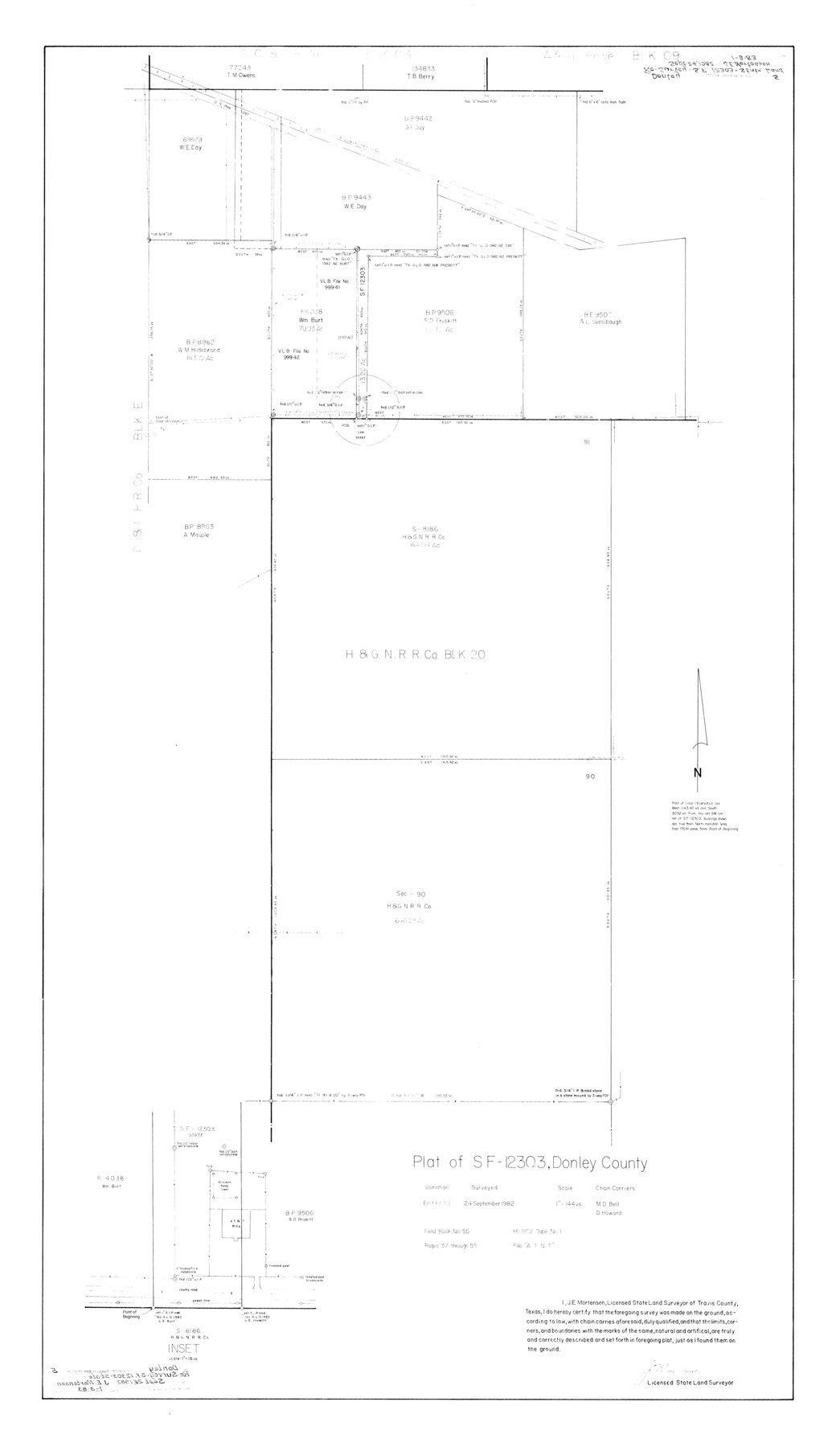
Donley County Rolled Sketch 5
Plat of SF-12303, Donley County
-
Map/Doc
8801
-
Collection
General Map Collection
-
Object Dates
1982/9/24 (Creation Date)
1983/1/3 (File Date)
-
People and Organizations
James E. Mortensen (Surveyor/Engineer)
M. D. Bell (Chainman/Field Personnel)
Douglas Howard (Chainman/Field Personnel)
-
Counties
Donley
-
Subjects
Surveying Rolled Sketch
-
Height x Width
56.6 x 32.9 inches
143.8 x 83.6 cm
-
Scale
1" = 144 varas
Part of: General Map Collection
Galveston Bay Entrance - Galveston and Texas City Harbors

Print $40.00
- Digital $50.00
Galveston Bay Entrance - Galveston and Texas City Harbors
1973
Size 37.0 x 53.0 inches
Map/Doc 69863
Hays County Working Sketch 3

Print $20.00
- Digital $50.00
Hays County Working Sketch 3
1925
Size 28.2 x 24.1 inches
Map/Doc 66077

Gonzales County Rolled Sketch 1

Print $20.00
- Digital $50.00
Gonzales County Rolled Sketch 1
1917
Size 21.9 x 23.9 inches
Map/Doc 6027
Edwards County Rolled Sketch 17

Print $20.00
- Digital $50.00
Edwards County Rolled Sketch 17
1945
Size 27.6 x 19.4 inches
Map/Doc 5806
San Saba County Sketch File 12

Print $6.00
- Digital $50.00
San Saba County Sketch File 12
Size 11.8 x 9.3 inches
Map/Doc 36439
Kent County Working Sketch Graphic Index

Print $20.00
- Digital $50.00
Kent County Working Sketch Graphic Index
1971
Size 44.7 x 37.0 inches
Map/Doc 76604
Bowie County Rolled Sketch 5

Print $20.00
- Digital $50.00
Bowie County Rolled Sketch 5
Size 33.1 x 44.5 inches
Map/Doc 8457
Runnels County Working Sketch 25

Print $20.00
- Digital $50.00
Runnels County Working Sketch 25
1955
Size 38.2 x 47.1 inches
Map/Doc 63621
Lipscomb County Rolled Sketch 2

Print $20.00
- Digital $50.00
Lipscomb County Rolled Sketch 2
1886
Size 24.1 x 30.2 inches
Map/Doc 6628
Flight Mission No. BRE-2P, Frame 98, Nueces County

Print $20.00
- Digital $50.00
Flight Mission No. BRE-2P, Frame 98, Nueces County
1956
Size 18.5 x 22.4 inches
Map/Doc 86783
Brewster County Rolled Sketch 22C

Print $20.00
- Digital $50.00
Brewster County Rolled Sketch 22C
1910
Size 23.7 x 18.8 inches
Map/Doc 5204
You may also like
Crockett County Working Sketch 94

Print $20.00
- Digital $50.00
Crockett County Working Sketch 94
1979
Size 43.1 x 28.7 inches
Map/Doc 68427
G. C. & S. F. Ry. Alinement [sic] and Right of Way Map of Dallas Branch, Johnson County, Texas
![64650, G. C. & S. F. Ry. Alinement [sic] and Right of Way Map of Dallas Branch, Johnson County, Texas, General Map Collection](https://historictexasmaps.com/wmedia_w700/maps/64650.tif.jpg)
Print $40.00
- Digital $50.00
G. C. & S. F. Ry. Alinement [sic] and Right of Way Map of Dallas Branch, Johnson County, Texas
1925
Size 38.0 x 125.2 inches
Map/Doc 64650
A Geographically Correct County Map of States Traversed by the St. Louis, Iron Mountain and Southern Railway and its connections

Print $20.00
- Digital $50.00
A Geographically Correct County Map of States Traversed by the St. Louis, Iron Mountain and Southern Railway and its connections
1878
Size 16.9 x 27.0 inches
Map/Doc 95785
Coryell County Boundary File 1 and 1a

Print $8.00
- Digital $50.00
Coryell County Boundary File 1 and 1a
Size 8.2 x 3.3 inches
Map/Doc 51890
Pecos County Sketch File 107

Print $4.00
- Digital $50.00
Pecos County Sketch File 107
Size 14.4 x 8.7 inches
Map/Doc 34035
Hemphill County Working Sketch 34

Print $40.00
- Digital $50.00
Hemphill County Working Sketch 34
1976
Size 33.9 x 64.2 inches
Map/Doc 66129
Dimmit County Working Sketch 29
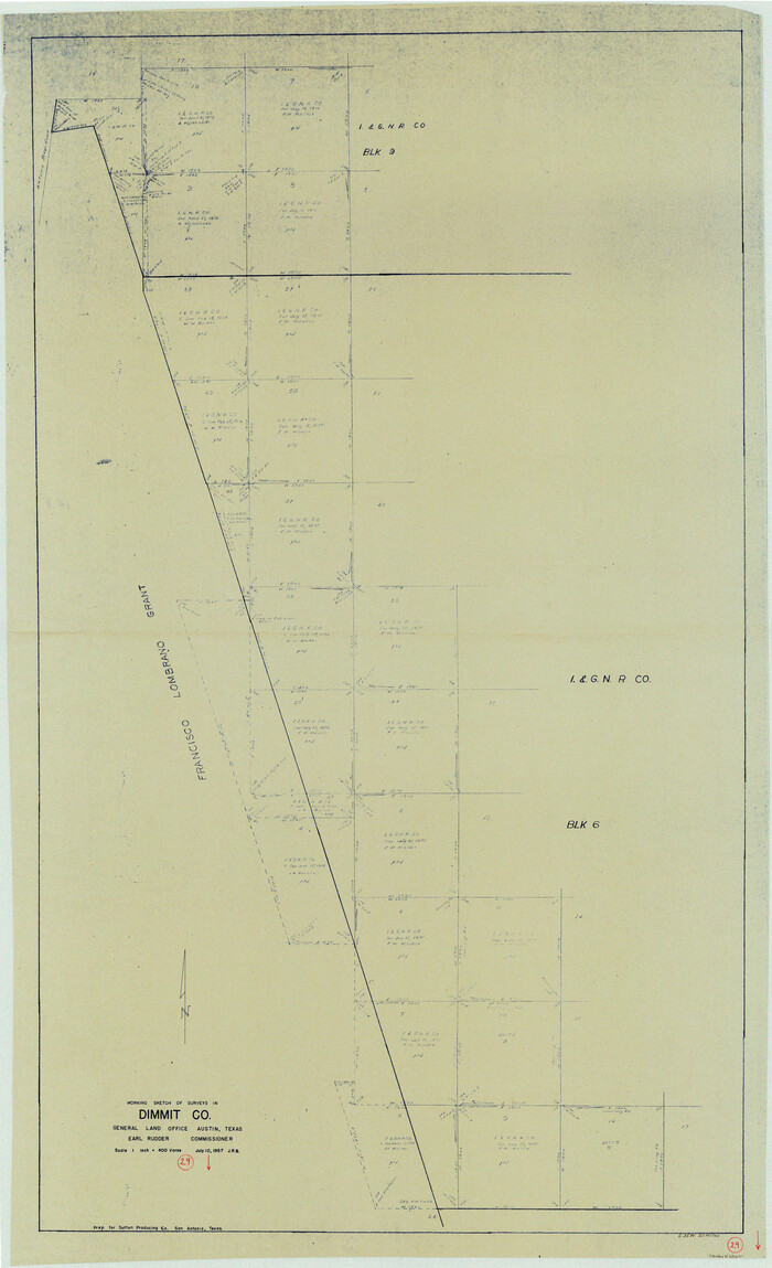
Print $40.00
- Digital $50.00
Dimmit County Working Sketch 29
1957
Size 58.1 x 36.2 inches
Map/Doc 68690

Bosque County Working Sketch 6

Print $20.00
- Digital $50.00
Bosque County Working Sketch 6
1939
Size 22.3 x 35.6 inches
Map/Doc 67439
Sabine River, Gladewater Sheet

Print $20.00
- Digital $50.00
Sabine River, Gladewater Sheet
1933
Size 38.5 x 30.9 inches
Map/Doc 65138
Stonewall County Rolled Sketch 18

Print $20.00
- Digital $50.00
Stonewall County Rolled Sketch 18
1950
Size 27.4 x 29.4 inches
Map/Doc 7872
