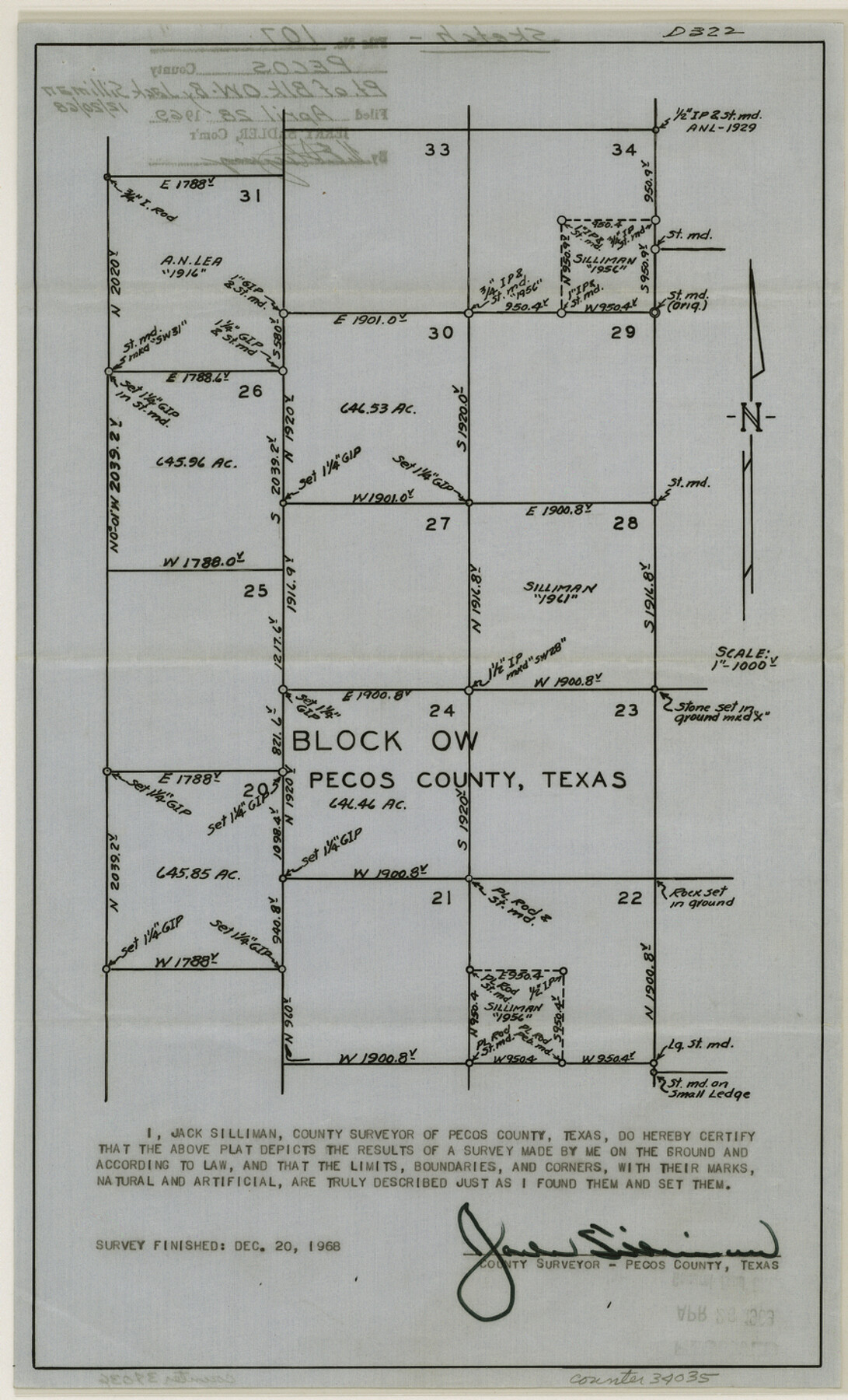
Pecos County Sketch File 107
[Sketch of a part of Block OW]
-
Map/Doc
34035
-
Collection
General Map Collection
-
Object Dates
1969/4/28 (File Date)
1968/12/20 (Survey Date)
-
People and Organizations
Victor E. Sterzing (Surveyor/Engineer)
Jack Silliman (Surveyor/Engineer)
-
Counties
Pecos
-
Subjects
Surveying Sketch File
-
Height x Width
14.4 x 8.7 inches
36.6 x 22.1 cm
-
Medium
paper, print with manuscript additions
Part of: General Map Collection
Shelby County Sketch File 11

Print $50.00
- Digital $50.00
Shelby County Sketch File 11
1859
Size 8.8 x 7.0 inches
Map/Doc 36613
Oldham County Sketch File 2

Print $6.00
- Digital $50.00
Oldham County Sketch File 2
1882
Size 12.7 x 8.2 inches
Map/Doc 33225
Ward County Rolled Sketch 24E

Print $40.00
- Digital $50.00
Ward County Rolled Sketch 24E
1967
Size 42.3 x 64.9 inches
Map/Doc 10116
Flight Mission No. BQR-5K, Frame 68, Brazoria County

Print $20.00
- Digital $50.00
Flight Mission No. BQR-5K, Frame 68, Brazoria County
1952
Size 18.8 x 22.5 inches
Map/Doc 84013
Gaines County Rolled Sketch 14B

Print $40.00
- Digital $50.00
Gaines County Rolled Sketch 14B
1940
Size 142.9 x 24.0 inches
Map/Doc 9032
Map showing survey for proposed ship channel from Brownsville to Brazos Santiago Pass

Print $20.00
- Digital $50.00
Map showing survey for proposed ship channel from Brownsville to Brazos Santiago Pass
1912
Size 18.1 x 27.7 inches
Map/Doc 72904
Flight Mission No. CUG-2P, Frame 28, Kleberg County

Print $20.00
- Digital $50.00
Flight Mission No. CUG-2P, Frame 28, Kleberg County
1956
Size 18.5 x 22.2 inches
Map/Doc 86193
Karnes County Working Sketch 9

Print $20.00
- Digital $50.00
Karnes County Working Sketch 9
1962
Size 37.1 x 28.9 inches
Map/Doc 66657
Maverick County Working Sketch 4

Print $40.00
- Digital $50.00
Maverick County Working Sketch 4
1944
Size 51.3 x 30.7 inches
Map/Doc 70896
Trinity River, Grapevine Sheet/Denton Creek

Print $6.00
- Digital $50.00
Trinity River, Grapevine Sheet/Denton Creek
1938
Size 22.2 x 34.7 inches
Map/Doc 65243
Concho County Working Sketch 11

Print $20.00
- Digital $50.00
Concho County Working Sketch 11
1951
Size 22.0 x 23.2 inches
Map/Doc 68193
Uvalde County Boundary File 3

Print $28.00
- Digital $50.00
Uvalde County Boundary File 3
Size 13.1 x 8.4 inches
Map/Doc 59558
You may also like

Garza County Sketch File 2

Print $20.00
- Digital $50.00
Garza County Sketch File 2
Size 33.1 x 30.3 inches
Map/Doc 10462
Matagorda County Sketch File 5

Print $4.00
- Digital $50.00
Matagorda County Sketch File 5
Size 10.0 x 8.0 inches
Map/Doc 30736
Wilson County Sketch File 12

Print $8.00
- Digital $50.00
Wilson County Sketch File 12
1841
Size 14.1 x 8.6 inches
Map/Doc 40425
Erath County Sketch File 21

Print $6.00
- Digital $50.00
Erath County Sketch File 21
Size 9.9 x 12.2 inches
Map/Doc 22302
Flight Mission No. DQN-3K, Frame 52, Calhoun County

Print $20.00
- Digital $50.00
Flight Mission No. DQN-3K, Frame 52, Calhoun County
1953
Size 18.4 x 22.2 inches
Map/Doc 84353
Map of Leon County

Print $20.00
- Digital $50.00
Map of Leon County
1871
Size 23.6 x 21.2 inches
Map/Doc 3808
Winkler County

Print $20.00
- Digital $50.00
Winkler County
1901
Size 36.2 x 45.8 inches
Map/Doc 93038
Wharton County Sketch File 14

Print $70.00
- Digital $50.00
Wharton County Sketch File 14
1895
Size 9.7 x 6.2 inches
Map/Doc 39938
W. D. Twichell's R. S. Hunnicutt's Resurvey in Oldham County, Texas June to November, 1915

Print $40.00
- Digital $50.00
W. D. Twichell's R. S. Hunnicutt's Resurvey in Oldham County, Texas June to November, 1915
1915
Size 71.3 x 42.6 inches
Map/Doc 89799
Subdivision of School Land League 12

Print $2.00
- Digital $50.00
Subdivision of School Land League 12
Size 8.7 x 11.2 inches
Map/Doc 90988
Shackelford County Sketch File 10

Print $20.00
- Digital $50.00
Shackelford County Sketch File 10
1918
Size 31.4 x 19.9 inches
Map/Doc 12316