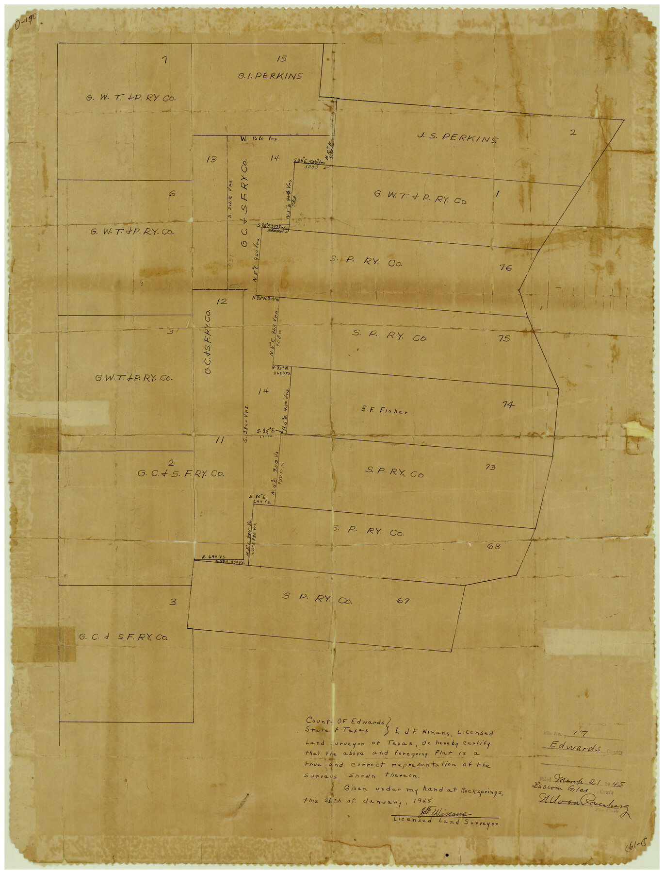
Edwards County Rolled Sketch 17
[Section 14, G. C. & S. F. Ry. Co. west of S. P. Ry. Co. surveys on Nueces River]
-
Map/Doc
5806
-
Collection
General Map Collection
-
Object Dates
1945/1/26 (Creation Date)
1945/3/21 (File Date)
-
People and Organizations
J.F. Winans (Surveyor/Engineer)
-
Counties
Edwards
-
Subjects
Cadastral Surveying Rolled Sketch
-
Height x Width
27.6 x 19.4 inches
70.1 x 49.3 cm
-
Medium
paper, manuscript
Part of: General Map Collection
Montgomery County Working Sketch 21
![71128, Montgomery County Working Sketch 21, General Map Collection](https://historictexasmaps.com/wmedia_w700/maps/71128.tif.jpg)
Print $20.00
- Digital $50.00
Montgomery County Working Sketch 21
Size 16.4 x 37.0 inches
Map/Doc 71128
Culberson County Working Sketch 63
![68517, Culberson County Working Sketch 63, General Map Collection](https://historictexasmaps.com/wmedia_w700/maps/68517.tif.jpg)
Print $20.00
- Digital $50.00
Culberson County Working Sketch 63
Size 34.1 x 24.9 inches
Map/Doc 68517
Henderson County Rolled Sketch 11
![75950, Henderson County Rolled Sketch 11, General Map Collection](https://historictexasmaps.com/wmedia_w700/maps/75950.tif.jpg)
Print $20.00
- Digital $50.00
Henderson County Rolled Sketch 11
1915
Size 29.4 x 42.4 inches
Map/Doc 75950
Nueces County Rolled Sketch 116
![7141, Nueces County Rolled Sketch 116, General Map Collection](https://historictexasmaps.com/wmedia_w700/maps/7141.tif.jpg)
Print $40.00
- Digital $50.00
Nueces County Rolled Sketch 116
Size 29.6 x 58.3 inches
Map/Doc 7141
Mitchell County Sketch File 8
![12098, Mitchell County Sketch File 8, General Map Collection](https://historictexasmaps.com/wmedia_w700/pdf_converted_jpg/qi_pdf_thumbnail_8441.jpg)
Print $20.00
- Digital $50.00
Mitchell County Sketch File 8
1909
Size 26.9 x 20.9 inches
Map/Doc 12098
La Salle County Sketch File 19
![29509, La Salle County Sketch File 19, General Map Collection](https://historictexasmaps.com/wmedia_w700/pdf_converted_jpg/qi_pdf_thumbnail_12583.jpg)
Print $32.00
- Digital $50.00
La Salle County Sketch File 19
1885
Size 14.2 x 8.7 inches
Map/Doc 29509
Sketch of coast of Texas, Laguna Madre from Pt. of Rocks to Corpus Christi [and accompanying letter]
![72964, Sketch of coast of Texas, Laguna Madre from Pt. of Rocks to Corpus Christi [and accompanying letter], General Map Collection](https://historictexasmaps.com/wmedia_w700/maps/72964.tif.jpg)
Print $2.00
- Digital $50.00
Sketch of coast of Texas, Laguna Madre from Pt. of Rocks to Corpus Christi [and accompanying letter]
Size 11.2 x 8.8 inches
Map/Doc 72964
Throckmorton County Sketch File 13
![38120, Throckmorton County Sketch File 13, General Map Collection](https://historictexasmaps.com/wmedia_w700/pdf_converted_jpg/qi_pdf_thumbnail_14511.jpg)
Print $20.00
- Digital $50.00
Throckmorton County Sketch File 13
1994
Size 11.3 x 9.1 inches
Map/Doc 38120
Ochiltree County Boundary File 2
![57675, Ochiltree County Boundary File 2, General Map Collection](https://historictexasmaps.com/wmedia_w700/pdf_converted_jpg/qi_pdf_thumbnail_16627.jpg)
Print $4.00
- Digital $50.00
Ochiltree County Boundary File 2
Size 7.7 x 8.6 inches
Map/Doc 57675
Flight Mission No. DQN-6K, Frame 68, Calhoun County
![84440, Flight Mission No. DQN-6K, Frame 68, Calhoun County, General Map Collection](https://historictexasmaps.com/wmedia_w700/pdf_converted_jpg/qi_pdf_thumbnail_31657.jpg)
Print $20.00
- Digital $50.00
Flight Mission No. DQN-6K, Frame 68, Calhoun County
1953
Size 18.5 x 22.1 inches
Map/Doc 84440
Navigation Maps of Gulf Intracoastal Waterway, Port Arthur to Brownsville, Texas
![65436, Navigation Maps of Gulf Intracoastal Waterway, Port Arthur to Brownsville, Texas, General Map Collection](https://historictexasmaps.com/wmedia_w700/maps/65436.tif.jpg)
Print $4.00
- Digital $50.00
Navigation Maps of Gulf Intracoastal Waterway, Port Arthur to Brownsville, Texas
1951
Size 16.6 x 21.5 inches
Map/Doc 65436
Zavala County Sketch File 41
![12731, Zavala County Sketch File 41, General Map Collection](https://historictexasmaps.com/wmedia_w700/pdf_converted_jpg/qi_pdf_thumbnail_8991.jpg)
Print $20.00
- Digital $50.00
Zavala County Sketch File 41
1900
Size 24.0 x 21.6 inches
Map/Doc 12731
You may also like
Crockett County Working Sketch 37
![68370, Crockett County Working Sketch 37, General Map Collection](https://historictexasmaps.com/wmedia_w700/maps/68370.tif.jpg)
Print $20.00
- Digital $50.00
Crockett County Working Sketch 37
Size 30.5 x 24.4 inches
Map/Doc 68370
[Area between H. & T. C. Block 34, PSL Block B19 and University Lands Block 16]
![91957, [Area between H. & T. C. Block 34, PSL Block B19 and University Lands Block 16], Twichell Survey Records](https://historictexasmaps.com/wmedia_w700/maps/91957-1.tif.jpg)
Print $20.00
- Digital $50.00
[Area between H. & T. C. Block 34, PSL Block B19 and University Lands Block 16]
1929
Size 40.4 x 29.3 inches
Map/Doc 91957
Hansford County Boundary File 1a
![54244, Hansford County Boundary File 1a, General Map Collection](https://historictexasmaps.com/wmedia_w700/pdf_converted_jpg/qi_pdf_thumbnail_16147.jpg)
Print $2.00
- Digital $50.00
Hansford County Boundary File 1a
Size 11.2 x 8.8 inches
Map/Doc 54244
Edwards County Sketch File 44
![21777, Edwards County Sketch File 44, General Map Collection](https://historictexasmaps.com/wmedia_w700/pdf_converted_jpg/qi_pdf_thumbnail_10956.jpg)
Print $4.00
- Digital $50.00
Edwards County Sketch File 44
1948
Size 11.4 x 8.9 inches
Map/Doc 21777
Jack County Working Sketch Graphic Index
![76589, Jack County Working Sketch Graphic Index, General Map Collection](https://historictexasmaps.com/wmedia_w700/maps/76589.tif.jpg)
Print $20.00
- Digital $50.00
Jack County Working Sketch Graphic Index
1925
Size 45.4 x 37.3 inches
Map/Doc 76589
Blanco County Working Sketch 4
![67363, Blanco County Working Sketch 4, General Map Collection](https://historictexasmaps.com/wmedia_w700/maps/67363.tif.jpg)
Print $20.00
- Digital $50.00
Blanco County Working Sketch 4
1885
Size 20.1 x 19.4 inches
Map/Doc 67363
Jim Hogg Co. [and] Brooks Co.
![4756, Jim Hogg Co. [and] Brooks Co., General Map Collection](https://historictexasmaps.com/wmedia_w700/maps/4756.tif.jpg)
Print $20.00
- Digital $50.00
Jim Hogg Co. [and] Brooks Co.
1913
Size 31.8 x 41.8 inches
Map/Doc 4756
Hamilton County Sketch File 4
![24903, Hamilton County Sketch File 4, General Map Collection](https://historictexasmaps.com/wmedia_w700/pdf_converted_jpg/qi_pdf_thumbnail_11583.jpg)
Print $16.00
- Digital $50.00
Hamilton County Sketch File 4
Size 14.5 x 9.1 inches
Map/Doc 24903
Navasota River, Springfield Sheet
![65074, Navasota River, Springfield Sheet, General Map Collection](https://historictexasmaps.com/wmedia_w700/maps/65074.tif.jpg)
Print $20.00
- Digital $50.00
Navasota River, Springfield Sheet
1934
Size 41.5 x 37.8 inches
Map/Doc 65074
Flight Mission No. DCL-6C, Frame 176, Kenedy County
![85988, Flight Mission No. DCL-6C, Frame 176, Kenedy County, General Map Collection](https://historictexasmaps.com/wmedia_w700/pdf_converted_jpg/qi_pdf_thumbnail_33134.jpg)
Print $20.00
- Digital $50.00
Flight Mission No. DCL-6C, Frame 176, Kenedy County
1943
Size 18.6 x 22.2 inches
Map/Doc 85988
Map of Travis County
![82083, Map of Travis County, General Map Collection](https://historictexasmaps.com/wmedia_w700/maps/82083-1.tif.jpg)
Print $40.00
- Digital $50.00
Map of Travis County
1895
Size 48.8 x 54.1 inches
Map/Doc 82083
Jefferson Co.
![73196, Jefferson Co., General Map Collection](https://historictexasmaps.com/wmedia_w700/maps/73196.tif.jpg)
Print $40.00
- Digital $50.00
Jefferson Co.
1978
Size 48.2 x 42.7 inches
Map/Doc 73196