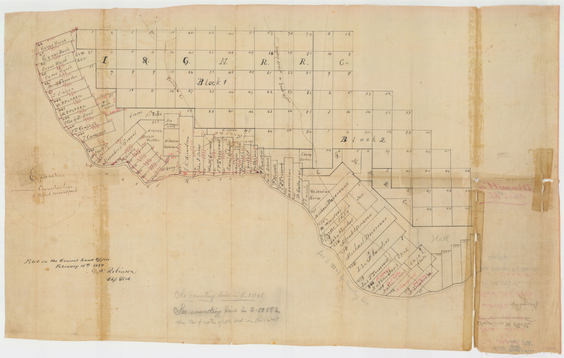
Dimmit County Sketch File 15
[Large area in eastern part of county]
-
Map/Doc
11343
-
Collection
General Map Collection
-
Object Dates
1883/3/29 (Creation Date)
1883/3/29 (File Date)
1884/2/15 (File Date)
-
People and Organizations
E. Schutze (Draftsman)
-
Counties
Dimmit
-
Subjects
Surveying Sketch File
-
Height x Width
18.1 x 31.4 inches
46.0 x 79.8 cm
-
Medium
paper, manuscript
-
Features
Arroyo Negro
Sous Mocho
Tortuga Creek
Nueces River
Part of: General Map Collection
Hartley County Sketch File 4

Print $6.00
- Digital $50.00
Hartley County Sketch File 4
1883
Size 10.6 x 8.1 inches
Map/Doc 26087
North Part Brewster Co.

Print $40.00
- Digital $50.00
North Part Brewster Co.
1914
Size 40.6 x 49.2 inches
Map/Doc 66729
Crockett County Sketch File 84

Print $6.00
- Digital $50.00
Crockett County Sketch File 84
1942
Size 11.4 x 8.9 inches
Map/Doc 19905
Reeves County Rolled Sketch 24

Print $20.00
- Digital $50.00
Reeves County Rolled Sketch 24
1982
Size 37.2 x 24.9 inches
Map/Doc 7493
Map showing S. A. & A. P. Ry. from San Antonio to Kendall County line

Print $40.00
- Digital $50.00
Map showing S. A. & A. P. Ry. from San Antonio to Kendall County line
1895
Size 25.1 x 76.7 inches
Map/Doc 64254
Texas Gulf Coast Map from the Sabine River to the Rio Grande as subdivided for mineral development

Print $40.00
- Digital $50.00
Texas Gulf Coast Map from the Sabine River to the Rio Grande as subdivided for mineral development
1948
Size 49.3 x 55.7 inches
Map/Doc 2906
Orange County Rolled Sketch 21

Print $20.00
- Digital $50.00
Orange County Rolled Sketch 21
Size 34.3 x 42.5 inches
Map/Doc 9646
Ellis County Sketch File 15

Print $40.00
- Digital $50.00
Ellis County Sketch File 15
1861
Size 15.7 x 12.5 inches
Map/Doc 21856
Flight Mission No. CGI-3N, Frame 124, Cameron County

Print $20.00
- Digital $50.00
Flight Mission No. CGI-3N, Frame 124, Cameron County
1954
Size 18.5 x 22.2 inches
Map/Doc 84597
Flight Mission No. CRC-2R, Frame 3, Chambers County

Print $20.00
- Digital $50.00
Flight Mission No. CRC-2R, Frame 3, Chambers County
1956
Size 18.8 x 22.5 inches
Map/Doc 84722
Montgomery County Rolled Sketch 17

Print $20.00
- Digital $50.00
Montgomery County Rolled Sketch 17
1932
Size 26.6 x 34.9 inches
Map/Doc 6805
Crosby County Sketch File 28

Print $20.00
- Digital $50.00
Crosby County Sketch File 28
Size 33.4 x 37.4 inches
Map/Doc 10353
You may also like
Routes to HemisFair '68 : World's Fair, San Antonio, Texas, April 6 through Oct. 6, 1968 [Verso]
![94169, Hemisfair Gulf Tourgide Map [Verso], General Map Collection](https://historictexasmaps.com/wmedia_w700/maps/94169.tif.jpg)
Routes to HemisFair '68 : World's Fair, San Antonio, Texas, April 6 through Oct. 6, 1968 [Verso]
Size 18.3 x 24.3 inches
Map/Doc 94169

Rusk County Sketch File X

Print $20.00
Rusk County Sketch File X
1844
Size 18.3 x 22.4 inches
Map/Doc 12279
Bee County Sketch File X

Print $6.00
- Digital $50.00
Bee County Sketch File X
Size 11.5 x 11.0 inches
Map/Doc 14243
Town of Beaumont in Jefferson County, Texas

Print $20.00
Town of Beaumont in Jefferson County, Texas
1850
Size 17.6 x 24.3 inches
Map/Doc 76267
[Texas and Pacific Railroad Co. Blocks 55, 54 and 76, Townships 1 & 2]
![89882, [Texas and Pacific Railroad Co. Blocks 55, 54 and 76, Townships 1 & 2], Twichell Survey Records](https://historictexasmaps.com/wmedia_w700/maps/89882-1.tif.jpg)
Print $20.00
- Digital $50.00
[Texas and Pacific Railroad Co. Blocks 55, 54 and 76, Townships 1 & 2]
Size 46.2 x 41.5 inches
Map/Doc 89882
Right-of-way & Track Map Dawson Railway Operated by the El Paso & Southwestern Company Station 1444+61.7 to Station 1655+23.4

Print $40.00
- Digital $50.00
Right-of-way & Track Map Dawson Railway Operated by the El Paso & Southwestern Company Station 1444+61.7 to Station 1655+23.4
1910
Size 56.7 x 24.8 inches
Map/Doc 89655
The Chief Justice County of Mina. Lands in Conflict with Colorado County

Print $20.00
The Chief Justice County of Mina. Lands in Conflict with Colorado County
2020
Size 15.8 x 21.7 inches
Map/Doc 96062
Surveyor's Watercourse Report 1

Print $34.00
Surveyor's Watercourse Report 1
2025
Size 11.0 x 8.5 inches
Map/Doc 97511
Zavala County Working Sketch 13

Print $20.00
- Digital $50.00
Zavala County Working Sketch 13
1975
Size 20.1 x 27.4 inches
Map/Doc 62088
Garza County Sketch File 19

Print $20.00
- Digital $50.00
Garza County Sketch File 19
1905
Size 21.8 x 23.0 inches
Map/Doc 11546
Webb County Rolled Sketch EF3

Print $20.00
- Digital $50.00
Webb County Rolled Sketch EF3
Size 24.1 x 27.0 inches
Map/Doc 8225