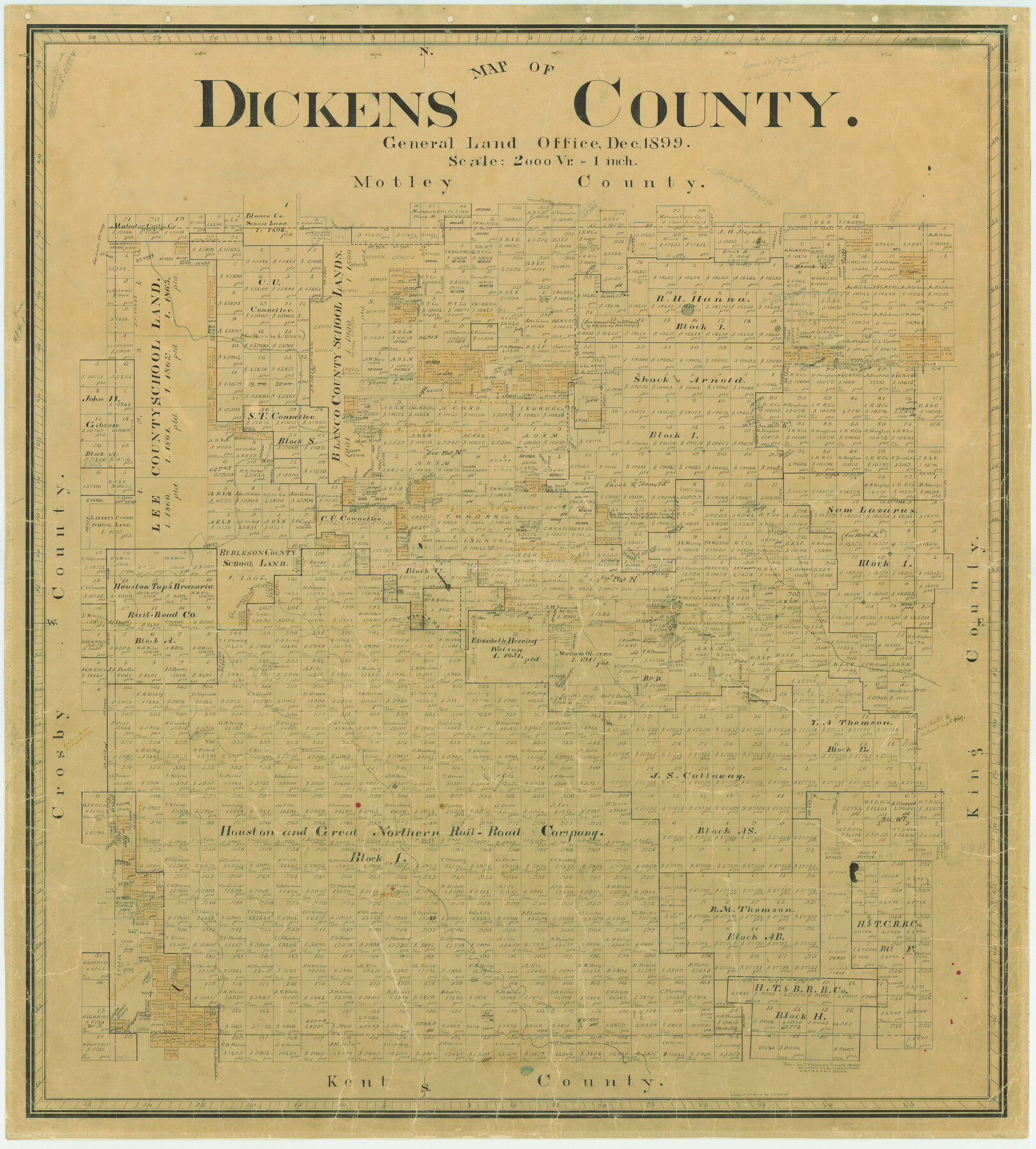
Map of Dickens County
-
Map/Doc
16822
-
Collection
General Map Collection
-
Object Dates
1899 (Creation Date)
-
People and Organizations
Texas General Land Office (Publisher)
John D. Hedick (Draftsman)
John D. Hedick (Compiler)
-
Counties
Dickens
-
Subjects
County
-
Height x Width
40.7 x 36.7 inches
103.4 x 93.2 cm
-
Comments
Conservation funded in 2004 with donation from Red McCombs.
-
Features
Jackson's Creek
Pease River
McKenzie Peak
Dickens
Geneva Fork Creek
Dockum's Ranch
Spur Headquarters
Soldiers Mountain
Spur
Duck Creek
Steele Hill
Big Red Mud Creek
Jackson's Branch of Pease River
Corkeye Creek
Part of: General Map Collection
Smith County Working Sketch 9

Print $40.00
- Digital $50.00
Smith County Working Sketch 9
1947
Size 48.8 x 44.2 inches
Map/Doc 63894
Presidio County Sketch File 57

Print $8.00
- Digital $50.00
Presidio County Sketch File 57
1938
Size 14.3 x 8.9 inches
Map/Doc 34624
Texas, Matagorda Bay, Vicinity of Trespalacios Bay

Print $40.00
- Digital $50.00
Texas, Matagorda Bay, Vicinity of Trespalacios Bay
1933
Size 49.0 x 32.6 inches
Map/Doc 69988
Washington County

Print $20.00
- Digital $50.00
Washington County
1976
Size 31.7 x 47.3 inches
Map/Doc 95667
La Salle County Working Sketch 21

Print $20.00
- Digital $50.00
La Salle County Working Sketch 21
1942
Size 25.4 x 24.0 inches
Map/Doc 70322

Map of Maverick County

Print $20.00
- Digital $50.00
Map of Maverick County
1874
Size 31.5 x 20.9 inches
Map/Doc 3848
Swisher County Sketch File 2a

Print $96.00
- Digital $50.00
Swisher County Sketch File 2a
1891
Size 14.3 x 8.7 inches
Map/Doc 37578
Webb County Boundary File 8

Print $113.00
- Digital $50.00
Webb County Boundary File 8
Size 14.3 x 8.8 inches
Map/Doc 59822
Gaines County Working Sketch 13

Print $20.00
- Digital $50.00
Gaines County Working Sketch 13
1954
Size 36.8 x 39.4 inches
Map/Doc 69313
United States - Gulf Coast Texas - Southern part of Laguna Madre

Print $20.00
- Digital $50.00
United States - Gulf Coast Texas - Southern part of Laguna Madre
1941
Size 26.7 x 18.5 inches
Map/Doc 72942
Crockett County Sketch File 66

Print $6.00
- Digital $50.00
Crockett County Sketch File 66
1927
Size 10.2 x 11.3 inches
Map/Doc 19853
You may also like
Atascosa County Sketch File 32

Print $40.00
- Digital $50.00
Atascosa County Sketch File 32
Size 17.6 x 19.6 inches
Map/Doc 10864
Flight Mission No. DCL-7C, Frame 147, Kenedy County

Print $20.00
- Digital $50.00
Flight Mission No. DCL-7C, Frame 147, Kenedy County
1943
Size 18.3 x 22.4 inches
Map/Doc 86104
Dimmit County Working Sketch 50

Print $20.00
- Digital $50.00
Dimmit County Working Sketch 50
1981
Size 34.0 x 39.0 inches
Map/Doc 68711
Crockett County Working Sketch 30

Print $20.00
- Digital $50.00
Crockett County Working Sketch 30
1924
Size 30.1 x 22.1 inches
Map/Doc 68363
Brewster County Working Sketch 42

Print $20.00
- Digital $50.00
Brewster County Working Sketch 42
1947
Size 39.9 x 31.0 inches
Map/Doc 67576
Hutchinson County Rolled Sketch 36

Print $20.00
- Digital $50.00
Hutchinson County Rolled Sketch 36
1888
Size 20.3 x 25.3 inches
Map/Doc 6293
Winkler County

Print $20.00
- Digital $50.00
Winkler County
1901
Size 36.2 x 45.8 inches
Map/Doc 93038
Hemphill County Sketch File 4

Print $14.00
- Digital $50.00
Hemphill County Sketch File 4
1903
Size 14.1 x 8.7 inches
Map/Doc 26288
Aransas County Rolled Sketch 2

Print $40.00
- Digital $50.00
Aransas County Rolled Sketch 2
1950
Size 27.9 x 51.4 inches
Map/Doc 73613
Map of north end of Brazos Island

Print $20.00
- Digital $50.00
Map of north end of Brazos Island
1845
Size 24.2 x 18.3 inches
Map/Doc 72920
Stonewall County Rolled Sketch 36A

Print $20.00
- Digital $50.00
Stonewall County Rolled Sketch 36A
Size 17.6 x 22.4 inches
Map/Doc 76403
Culberson County Rolled Sketch 68

Print $20.00
- Digital $50.00
Culberson County Rolled Sketch 68
1997
Size 32.0 x 32.9 inches
Map/Doc 76402