Stonewall County Rolled Sketch 36A
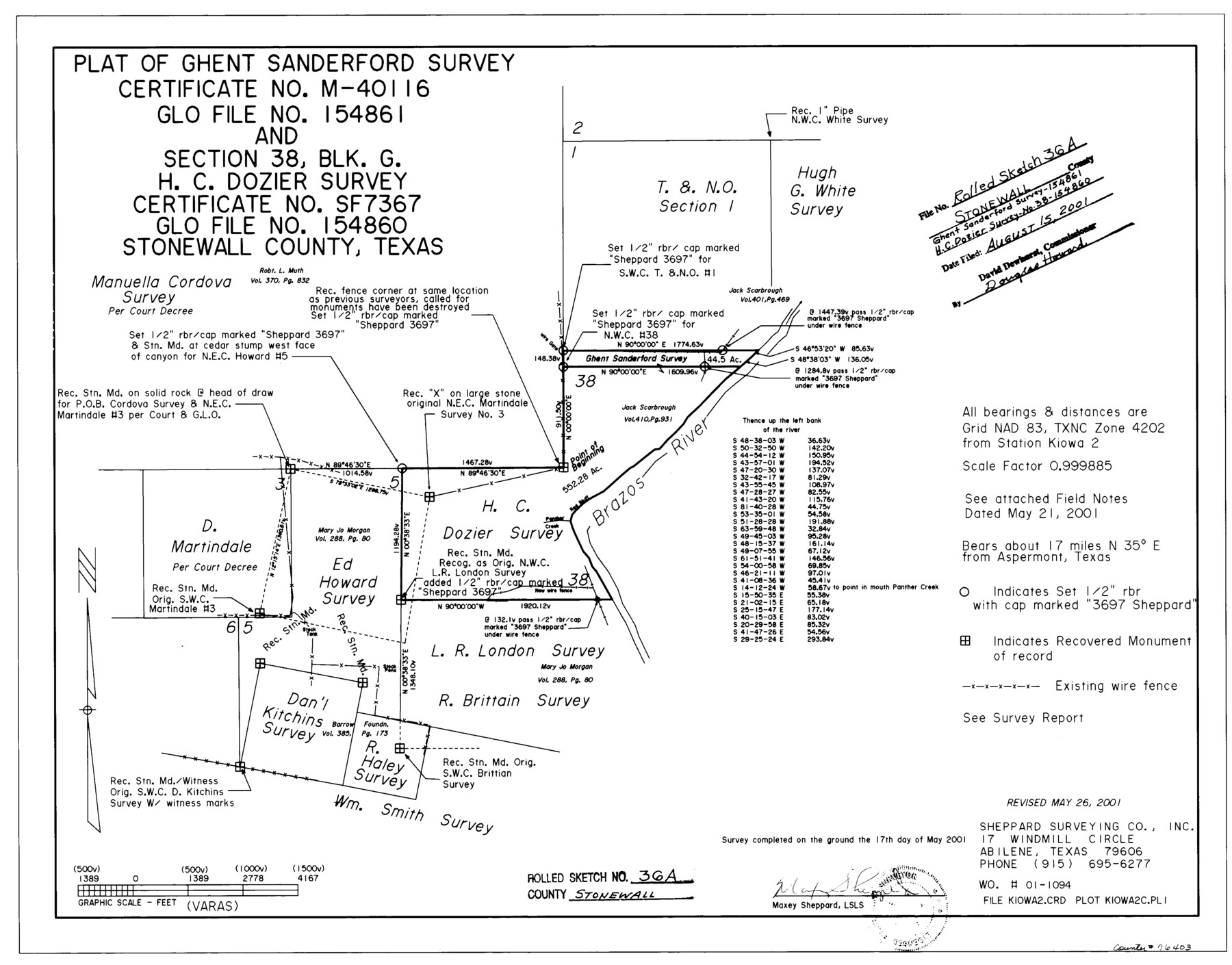
Plat of Ghent Sanderford survey certificate no. M-40116, GLO file no. 154861 and section 38, Blk. G, H.G. Dozier survey certificate no. SF-7367, GLO file no. 154860, Stonewall County, Texas
-
Map/Doc
76403
-
Collection
General Map Collection
-
Object Dates
2001/5/17 (Survey Date)
2001/8/15 (File Date)
2001/5/26 (Revision Date)
-
People and Organizations
Maxey Sheppard (Surveyor/Engineer)
-
Counties
Stonewall
-
Subjects
Surveying Rolled Sketch
-
Height x Width
17.6 x 22.4 inches
44.7 x 56.9 cm
-
Medium
mylar, print
Related maps
Stonewall County Sketch File 31

Print $77.00
- Digital $50.00
Stonewall County Sketch File 31
2001
Size 11.3 x 8.9 inches
Map/Doc 37308
Hudspeth County Rolled Sketch 41

Print $40.00
- Digital $50.00
Hudspeth County Rolled Sketch 41
1947
Size 11.3 x 96.3 inches
Map/Doc 9214
Part of: General Map Collection
Galveston County NRC Article 33.136 Sketch 92

Print $62.00
Galveston County NRC Article 33.136 Sketch 92
2021
Map/Doc 97179
Gaines County Working Sketch 29

Print $20.00
- Digital $50.00
Gaines County Working Sketch 29
1984
Size 32.3 x 42.9 inches
Map/Doc 69329
Colorado County Working Sketch 21

Print $20.00
- Digital $50.00
Colorado County Working Sketch 21
1963
Size 32.1 x 30.5 inches
Map/Doc 68121
Montgomery County Working Sketch 27

Print $20.00
- Digital $50.00
Montgomery County Working Sketch 27
1942
Size 42.1 x 33.4 inches
Map/Doc 71134
Nolan County Sketch File 1a

Print $20.00
- Digital $50.00
Nolan County Sketch File 1a
1882
Size 20.7 x 39.4 inches
Map/Doc 10554
Uvalde County Working Sketch 19

Print $20.00
- Digital $50.00
Uvalde County Working Sketch 19
1948
Size 25.8 x 39.8 inches
Map/Doc 72089
Eastland County Working Sketch 50

Print $20.00
- Digital $50.00
Eastland County Working Sketch 50
1981
Size 38.7 x 39.6 inches
Map/Doc 68831

Cuadro Historico-Geroglifico de la Peregrinacion de las Tribus Aztecas que Poblaron el Valle de Mexico (Num. 2)

Print $20.00
- Digital $50.00
Cuadro Historico-Geroglifico de la Peregrinacion de las Tribus Aztecas que Poblaron el Valle de Mexico (Num. 2)
Size 22.9 x 31.3 inches
Map/Doc 97012
Red River Co.

Print $20.00
- Digital $50.00
Red River Co.
1897
Size 46.8 x 36.0 inches
Map/Doc 16796
Brewster County Working Sketch 29

Print $20.00
- Digital $50.00
Brewster County Working Sketch 29
1941
Size 19.1 x 31.2 inches
Map/Doc 67563
Roberts County Working Sketch 38

Print $20.00
- Digital $50.00
Roberts County Working Sketch 38
1978
Size 26.7 x 22.5 inches
Map/Doc 63564
You may also like
Gillespie County Boundary File 5

Print $10.00
- Digital $50.00
Gillespie County Boundary File 5
Size 14.2 x 9.0 inches
Map/Doc 53764
Arlancy the Land of Plenty Farms

Print $20.00
- Digital $50.00
Arlancy the Land of Plenty Farms
1925
Size 10.9 x 16.6 inches
Map/Doc 96737
Orange County Aerial Photograph Index Sheet 3

Print $20.00
- Digital $50.00
Orange County Aerial Photograph Index Sheet 3
1953
Size 22.8 x 17.8 inches
Map/Doc 83741
Falls County Sketch File 18

Print $4.00
- Digital $50.00
Falls County Sketch File 18
Size 10.3 x 8.2 inches
Map/Doc 22380
Kendall County Rolled Sketch 8

Print $20.00
- Digital $50.00
Kendall County Rolled Sketch 8
1994
Size 17.0 x 18.3 inches
Map/Doc 6461
Map of Texas compiled from surveys at the Land Office of Texas

Print $20.00
- Digital $50.00
Map of Texas compiled from surveys at the Land Office of Texas
1851
Size 26.7 x 19.1 inches
Map/Doc 96431
Crosby County Boundary File 1

Print $20.00
- Digital $50.00
Crosby County Boundary File 1
Size 7.4 x 4.1 inches
Map/Doc 51971
Goliad County Sketch File 30

Print $40.00
- Digital $50.00
Goliad County Sketch File 30
Size 13.0 x 15.0 inches
Map/Doc 24327
Map Showing Lands Surveyed by Sylvan Sanders, Block D

Print $20.00
- Digital $50.00
Map Showing Lands Surveyed by Sylvan Sanders, Block D
Size 28.2 x 23.5 inches
Map/Doc 92440
Glasscock County

Print $20.00
- Digital $50.00
Glasscock County
1933
Size 41.1 x 34.7 inches
Map/Doc 77290
Parker County Working Sketch 9

Print $20.00
- Digital $50.00
Parker County Working Sketch 9
1958
Map/Doc 71459
Lipscomb County Rolled Sketch 5

Print $20.00
- Digital $50.00
Lipscomb County Rolled Sketch 5
1941
Size 45.8 x 23.3 inches
Map/Doc 9451