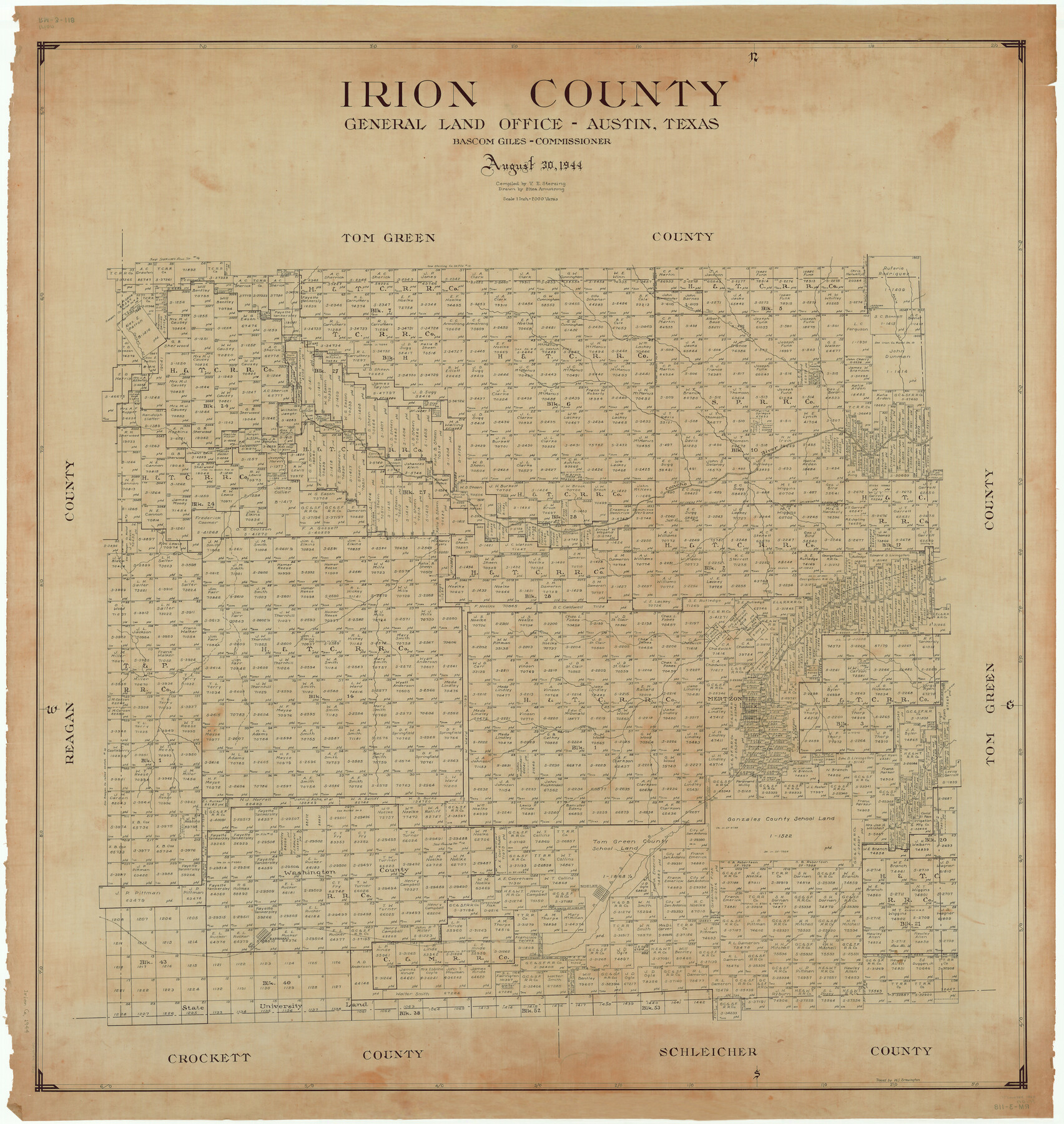
Irion County
RM-3-118
-
Map/Doc
1864
-
Collection
General Map Collection
-
Object Dates
1944/8/30 (Creation Date)
-
People and Organizations
Texas General Land Office (Publisher)
Bascom Giles (GLO Commissioner)
Eltea Armstrong (Draftsman)
Victor E. Sterzing (Compiler)
-
Counties
Irion
-
Subjects
County
-
Height x Width
45.3 x 42.9 inches
115.1 x 109.0 cm
-
Comments
Traced by W. S. Brewington.
Part of: General Map Collection
Brewster County Working Sketch 81

Print $20.00
- Digital $50.00
Brewster County Working Sketch 81
1972
Size 45.9 x 26.7 inches
Map/Doc 67681
[Sketch for Mineral Application 26501 - Sabine River, T. A. Oldhausen]
![2835, [Sketch for Mineral Application 26501 - Sabine River, T. A. Oldhausen], General Map Collection](https://historictexasmaps.com/wmedia_w700/maps/2835.tif.jpg)
Print $20.00
- Digital $50.00
[Sketch for Mineral Application 26501 - Sabine River, T. A. Oldhausen]
1931
Size 24.6 x 36.6 inches
Map/Doc 2835
Flight Mission No. BQR-7K, Frame 31, Brazoria County

Print $20.00
- Digital $50.00
Flight Mission No. BQR-7K, Frame 31, Brazoria County
1952
Size 18.6 x 22.1 inches
Map/Doc 84029
Coryell County Working Sketch 12

Print $20.00
- Digital $50.00
Coryell County Working Sketch 12
1949
Size 36.0 x 38.7 inches
Map/Doc 68219
Flight Mission No. BRA-7M, Frame 204, Jefferson County

Print $20.00
- Digital $50.00
Flight Mission No. BRA-7M, Frame 204, Jefferson County
1953
Size 18.6 x 22.3 inches
Map/Doc 85572
Wichita County Working Sketch 15

Print $20.00
- Digital $50.00
Wichita County Working Sketch 15
1919
Size 29.9 x 38.5 inches
Map/Doc 72525
Chambers County Sketch File 45

Print $70.00
- Digital $50.00
Chambers County Sketch File 45
Size 8.9 x 8.3 inches
Map/Doc 17743
Anderson County Rolled Sketch 14

Print $20.00
- Digital $50.00
Anderson County Rolled Sketch 14
1997
Size 30.1 x 36.5 inches
Map/Doc 77159
Pecos County Rolled Sketch 151

Print $20.00
- Digital $50.00
Pecos County Rolled Sketch 151
Size 40.6 x 23.6 inches
Map/Doc 7281
Hood County Working Sketch 28

Print $20.00
- Digital $50.00
Hood County Working Sketch 28
1995
Size 17.5 x 11.4 inches
Map/Doc 66222
Sterling County Rolled Sketch 12

Print $20.00
- Digital $50.00
Sterling County Rolled Sketch 12
1941
Size 35.6 x 35.0 inches
Map/Doc 9946
Flight Mission No. DCL-7C, Frame 44, Kenedy County

Print $20.00
- Digital $50.00
Flight Mission No. DCL-7C, Frame 44, Kenedy County
1943
Size 15.4 x 15.2 inches
Map/Doc 86032
You may also like
Gonzales County Working Sketch 4a

Print $20.00
- Digital $50.00
Gonzales County Working Sketch 4a
1979
Size 30.9 x 32.2 inches
Map/Doc 63219
Dickens County Rolled Sketch 12

Print $20.00
- Digital $50.00
Dickens County Rolled Sketch 12
1959
Size 33.5 x 39.7 inches
Map/Doc 8790
Roberts County Working Sketch 31

Print $20.00
- Digital $50.00
Roberts County Working Sketch 31
1978
Size 26.6 x 22.4 inches
Map/Doc 63557
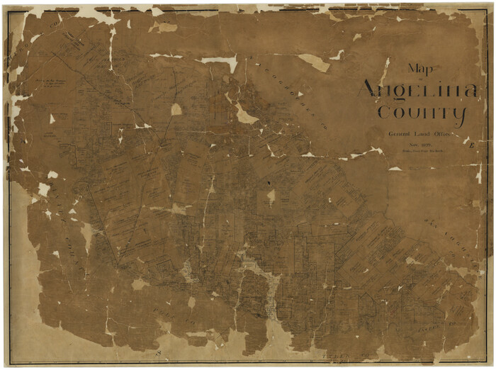
Map of Angelina County
Print $40.00
- Digital $50.00
Map of Angelina County
1899
Size 39.1 x 52.3 inches
Map/Doc 4777

[Surveys in Polk and Chambers Counties]
![355, [Surveys in Polk and Chambers Counties], General Map Collection](https://historictexasmaps.com/wmedia_w700/maps/355.tif.jpg)
Print $3.00
- Digital $50.00
[Surveys in Polk and Chambers Counties]
Size 11.7 x 14.4 inches
Map/Doc 355
Callahan County Working Sketch 14

Print $20.00
- Digital $50.00
Callahan County Working Sketch 14
2010
Size 25.8 x 23.7 inches
Map/Doc 89273
General Highway Map, Trinity County, Texas

Print $20.00
General Highway Map, Trinity County, Texas
1940
Size 18.4 x 24.9 inches
Map/Doc 79263
Brewster County Working Sketch 93

Print $40.00
- Digital $50.00
Brewster County Working Sketch 93
1975
Size 60.6 x 39.9 inches
Map/Doc 67693
Bee County Boundary File 3

Print $20.00
- Digital $50.00
Bee County Boundary File 3
Size 22.3 x 16.2 inches
Map/Doc 50440
Wilbarger County Rolled Sketch 8

Print $20.00
- Digital $50.00
Wilbarger County Rolled Sketch 8
1965
Size 22.0 x 18.9 inches
Map/Doc 8257
Map of Jones County, Texas

Print $20.00
Map of Jones County, Texas
1879
Size 24.7 x 18.8 inches
Map/Doc 88960