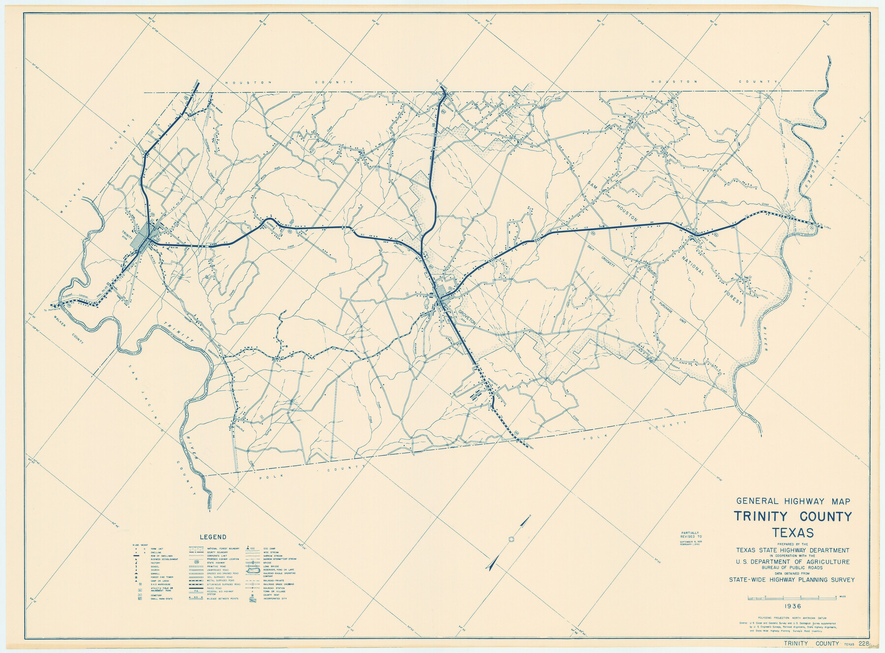
General Highway Map, Trinity County, Texas
-
Map/Doc
79263
-
Collection
Texas State Library and Archives
-
Object Dates
1940 (Creation Date)
-
People and Organizations
Texas State Highway Department (Publisher)
-
Counties
Trinity
-
Subjects
County
-
Height x Width
18.4 x 24.9 inches
46.7 x 63.3 cm
-
Comments
Prints available courtesy of the Texas State Library and Archives.
More info can be found here: TSLAC Map 05010
Part of: Texas State Library and Archives
General Highway Map, Hardin County, Texas

Print $20.00
General Highway Map, Hardin County, Texas
1940
Size 18.4 x 24.8 inches
Map/Doc 79114
General Highway Map, Jones County, Texas

Print $20.00
General Highway Map, Jones County, Texas
1961
Size 18.2 x 24.5 inches
Map/Doc 79546
Map of Mexico, Texas, Old and New California, and Yucatan

Print $20.00
Map of Mexico, Texas, Old and New California, and Yucatan
1847
Size 17.9 x 24.4 inches
Map/Doc 76191
General Highway Map, Matagorda County, Texas

Print $20.00
General Highway Map, Matagorda County, Texas
1961
Size 24.8 x 18.2 inches
Map/Doc 79585
General Highway Map, Motley County, Texas

Print $20.00
General Highway Map, Motley County, Texas
1961
Size 24.7 x 18.1 inches
Map/Doc 79605
General Highway Map, Duval County, Texas

Print $20.00
General Highway Map, Duval County, Texas
1961
Size 18.1 x 24.6 inches
Map/Doc 79448
General Highway Map, Baylor County, Texas

Print $20.00
General Highway Map, Baylor County, Texas
1961
Size 18.3 x 24.8 inches
Map/Doc 79363
General Highway Map. Detail of Cities and Towns in Smith County, Texas. City Map, Tyler, Smith County, Texas

Print $20.00
General Highway Map. Detail of Cities and Towns in Smith County, Texas. City Map, Tyler, Smith County, Texas
1961
Size 18.1 x 24.9 inches
Map/Doc 79656
General Highway Map, Tom Green County, Texas

Print $20.00
General Highway Map, Tom Green County, Texas
1961
Size 18.4 x 25.0 inches
Map/Doc 79678
General Highway Map, Runnels County, Texas

Print $20.00
General Highway Map, Runnels County, Texas
1961
Size 24.6 x 18.2 inches
Map/Doc 79642
General Highway Map. Detail of Cities and Towns in Collin County, Texas

Print $20.00
General Highway Map. Detail of Cities and Towns in Collin County, Texas
1961
Size 18.2 x 24.8 inches
Map/Doc 79414
General Highway Map. Detail of Cities and Towns in Dallas County, Texas [Dallas and vicinity]
![79431, General Highway Map. Detail of Cities and Towns in Dallas County, Texas [Dallas and vicinity], Texas State Library and Archives](https://historictexasmaps.com/wmedia_w700/maps/79431.tif.jpg)
Print $20.00
General Highway Map. Detail of Cities and Towns in Dallas County, Texas [Dallas and vicinity]
1961
Size 18.1 x 24.4 inches
Map/Doc 79431
You may also like
Corpus Christi Harbor

Print $40.00
- Digital $50.00
Corpus Christi Harbor
1973
Size 37.8 x 51.9 inches
Map/Doc 73478
Flight Mission No. DQN-1K, Frame 140, Calhoun County

Print $20.00
- Digital $50.00
Flight Mission No. DQN-1K, Frame 140, Calhoun County
1953
Size 18.5 x 22.2 inches
Map/Doc 84203
Dawson County Rolled Sketch 12

Print $20.00
- Digital $50.00
Dawson County Rolled Sketch 12
1965
Size 15.6 x 33.2 inches
Map/Doc 5695
[Map of California and Nevada]
![96620, [Map of California and Nevada], Cobb Digital Map Collection](https://historictexasmaps.com/wmedia_w700/maps/96620.tif.jpg)
Print $20.00
- Digital $50.00
[Map of California and Nevada]
1869
Size 9.1 x 10.6 inches
Map/Doc 96620
General Highway Map, Kaufman County, Texas

Print $20.00
General Highway Map, Kaufman County, Texas
1961
Size 24.9 x 18.1 inches
Map/Doc 79548
Wharton County Working Sketch 24

Print $20.00
- Digital $50.00
Wharton County Working Sketch 24
1909
Size 13.3 x 14.2 inches
Map/Doc 72488
Flight Mission No. CRC-1R, Frame 95, Chambers County

Print $20.00
- Digital $50.00
Flight Mission No. CRC-1R, Frame 95, Chambers County
1956
Size 18.7 x 22.3 inches
Map/Doc 84710
Matagorda County Rolled Sketch 9

Print $20.00
- Digital $50.00
Matagorda County Rolled Sketch 9
Size 36.8 x 30.0 inches
Map/Doc 6680
Garza County Sketch File G

Print $8.00
- Digital $50.00
Garza County Sketch File G
1904
Size 14.3 x 8.6 inches
Map/Doc 24026
Wharton County Rolled Sketch 14

Print $20.00
- Digital $50.00
Wharton County Rolled Sketch 14
2020
Size 36.1 x 24.3 inches
Map/Doc 95915
Andrews County Rolled Sketch 19

Print $20.00
- Digital $50.00
Andrews County Rolled Sketch 19
1945
Size 23.3 x 28.1 inches
Map/Doc 77167
Palo Pinto County Sketch File 3

Print $20.00
- Digital $50.00
Palo Pinto County Sketch File 3
1850
Size 24.6 x 19.3 inches
Map/Doc 12132