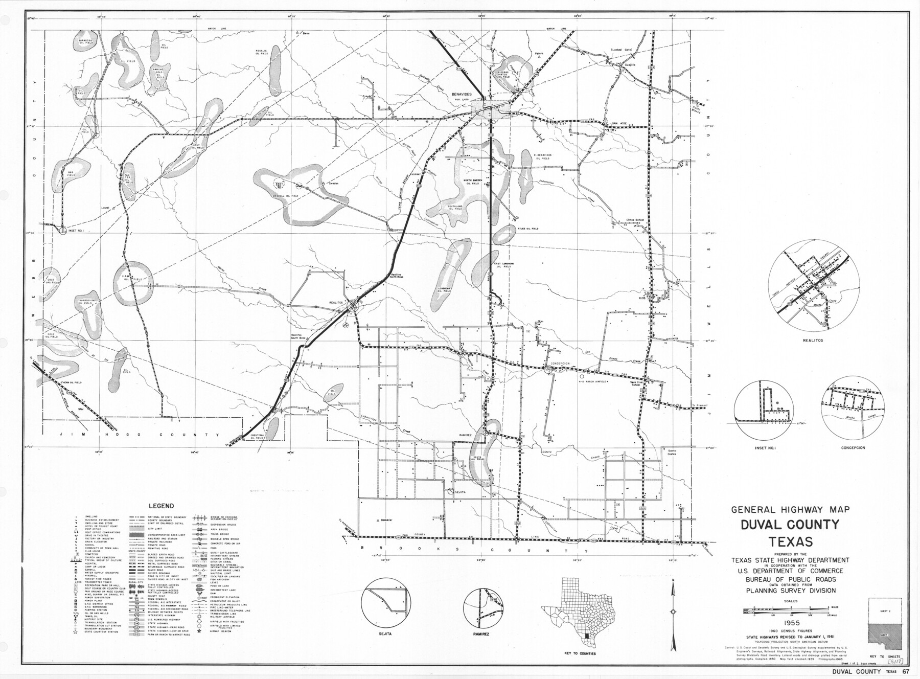
General Highway Map, Duval County, Texas
-
Map/Doc
79448
-
Collection
Texas State Library and Archives
-
Object Dates
1961 (Creation Date)
-
People and Organizations
Texas State Highway Department (Publisher)
-
Counties
Duval
-
Subjects
County
-
Height x Width
18.1 x 24.6 inches
46.0 x 62.5 cm
-
Comments
Prints available courtesy of the Texas State Library and Archives.
More info can be found here: TSLAC Map 05117
Part of: Texas State Library and Archives

General Highway Map, Stephens County, Texas

Print $20.00
General Highway Map, Stephens County, Texas
1940
Size 24.9 x 18.3 inches
Map/Doc 79247
General Highway Map, Nacogdoches County, Texas

Print $20.00
General Highway Map, Nacogdoches County, Texas
1940
Size 18.5 x 24.7 inches
Map/Doc 79205
General Highway Map, Cameron County, Texas

Print $20.00
General Highway Map, Cameron County, Texas
1940
Size 18.5 x 25.3 inches
Map/Doc 79039
General Highway Map, Stephens County, Texas

Print $20.00
General Highway Map, Stephens County, Texas
1961
Size 25.0 x 18.2 inches
Map/Doc 79660
General Highway Map, Jeff Davis County, Texas

Print $20.00
General Highway Map, Jeff Davis County, Texas
1961
Size 18.3 x 24.6 inches
Map/Doc 79536
General Highway Map, Medina County, Texas

Print $20.00
General Highway Map, Medina County, Texas
1940
Size 18.3 x 24.5 inches
Map/Doc 79194
General Highway Map, Martin County, Texas

Print $20.00
General Highway Map, Martin County, Texas
1961
Size 18.1 x 24.6 inches
Map/Doc 79583
Traveller's Map of the State of Texas

Print $20.00
Traveller's Map of the State of Texas
1867
Size 42.5 x 41.1 inches
Map/Doc 76226
General Highway Map. Detail of Cities and Towns in Wharton County, Texas [El Campo and Wharton]
![79275, General Highway Map. Detail of Cities and Towns in Wharton County, Texas [El Campo and Wharton], Texas State Library and Archives](https://historictexasmaps.com/wmedia_w700/maps/79275.tif.jpg)
Print $20.00
General Highway Map. Detail of Cities and Towns in Wharton County, Texas [El Campo and Wharton]
1940
Size 18.4 x 24.8 inches
Map/Doc 79275
General Highway Map, Nueces County, Texas

Print $20.00
General Highway Map, Nueces County, Texas
1961
Size 24.6 x 18.2 inches
Map/Doc 79616
General Highway Map, Foard County, Texas

Print $20.00
General Highway Map, Foard County, Texas
1961
Size 18.2 x 24.6 inches
Map/Doc 79468
You may also like
Presidio County Working Sketch 54

Print $20.00
- Digital $50.00
Presidio County Working Sketch 54
1955
Size 26.0 x 20.8 inches
Map/Doc 71731
Map of Texas from the most recent authorities

Print $20.00
Map of Texas from the most recent authorities
1845
Size 13.5 x 17.1 inches
Map/Doc 94574
Travis County Sketch File 75B

Print $20.00
- Digital $50.00
Travis County Sketch File 75B
1992
Size 37.4 x 26.7 inches
Map/Doc 12479
Crane County Rolled Sketch 26

Print $20.00
- Digital $50.00
Crane County Rolled Sketch 26
2020
Size 36.5 x 24.5 inches
Map/Doc 96432
Jim Wells County Working Sketch 1

Print $20.00
- Digital $50.00
Jim Wells County Working Sketch 1
Size 17.2 x 22.2 inches
Map/Doc 66599
Galveston County Sketch File 13

Print $20.00
- Digital $50.00
Galveston County Sketch File 13
Size 16.2 x 12.5 inches
Map/Doc 11530
[Maps of surveys in Reeves & Culberson Cos]
![61140, [Maps of surveys in Reeves & Culberson Cos], General Map Collection](https://historictexasmaps.com/wmedia_w700/maps/61140.tif.jpg)
Print $20.00
- Digital $50.00
[Maps of surveys in Reeves & Culberson Cos]
1937
Size 30.6 x 24.9 inches
Map/Doc 61140
Map of Galveston West Bay and Part of Galveston Island

Print $40.00
- Digital $50.00
Map of Galveston West Bay and Part of Galveston Island
1851
Size 31.2 x 52.6 inches
Map/Doc 69923
Mason County Working Sketch 21

Print $20.00
- Digital $50.00
Mason County Working Sketch 21
1945
Size 37.1 x 43.2 inches
Map/Doc 70857
McLaughlin Farm, Crosby County, Texas

Print $20.00
- Digital $50.00
McLaughlin Farm, Crosby County, Texas
1952
Size 14.3 x 14.1 inches
Map/Doc 92615
Motley County

Print $20.00
- Digital $50.00
Motley County
1914
Size 47.8 x 37.9 inches
Map/Doc 66947
Brazos River, Brazos River Sheet 5

Print $4.00
- Digital $50.00
Brazos River, Brazos River Sheet 5
1926
Size 29.4 x 22.5 inches
Map/Doc 65298