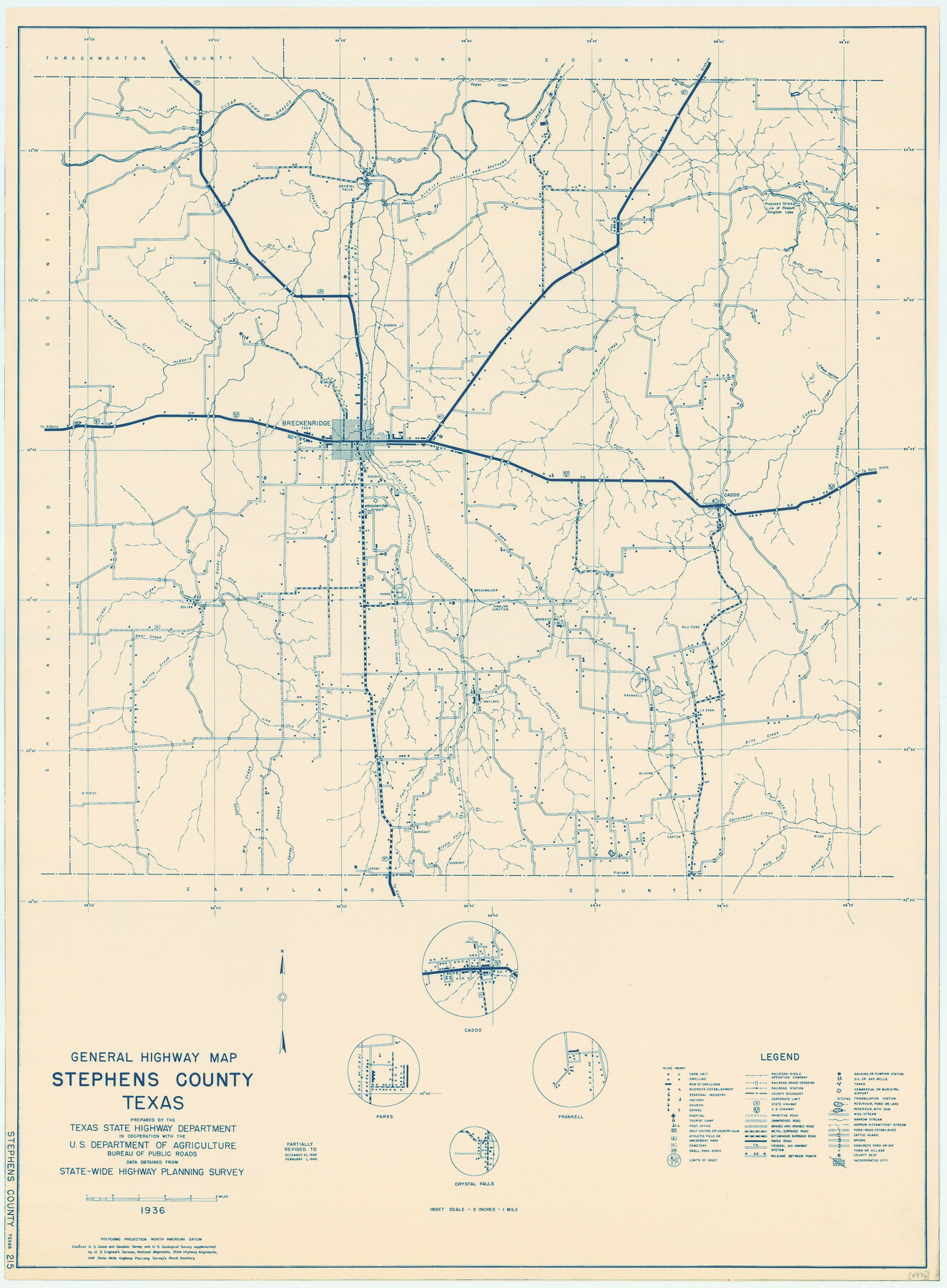
General Highway Map, Stephens County, Texas
-
Map/Doc
79247
-
Collection
Texas State Library and Archives
-
Object Dates
1940 (Creation Date)
-
People and Organizations
Texas State Highway Department (Publisher)
-
Counties
Stephens
-
Subjects
County
-
Height x Width
24.9 x 18.3 inches
63.3 x 46.5 cm
-
Comments
Prints available courtesy of the Texas State Library and Archives.
More info can be found here: TSLAC Map 04996
Part of: Texas State Library and Archives
General Highway Map, Webb County, Texas

Print $20.00
General Highway Map, Webb County, Texas
1940
Size 18.2 x 24.9 inches
Map/Doc 79273
General Highway Map, Cottle County, Texas

Print $20.00
General Highway Map, Cottle County, Texas
1940
Size 18.3 x 25.2 inches
Map/Doc 79060
General Highway Map, King County, Texas

Print $20.00
General Highway Map, King County, Texas
1961
Size 18.2 x 24.6 inches
Map/Doc 79555
J. De Cordova's Map of the State of Texas Compiled from the records of the General Land Office of the State

Print $20.00
J. De Cordova's Map of the State of Texas Compiled from the records of the General Land Office of the State
1856
Size 34.2 x 32.1 inches
Map/Doc 76222
General Highway Map, Hockley County, Texas

Print $20.00
General Highway Map, Hockley County, Texas
1961
Size 18.2 x 24.6 inches
Map/Doc 79522
General Highway Map, Falls County, Texas

Print $20.00
General Highway Map, Falls County, Texas
1961
Size 18.2 x 24.5 inches
Map/Doc 79462
General Highway Map. Detail of Cities and Towns in Harris County, Texas. City Map [of] Houston, Pasadena, West University Place, Bellaire, Galena Park, Jacinto City, South Houston, South Side Place, Deer Park, and vicinity, Harris County, Texas
![79505, General Highway Map. Detail of Cities and Towns in Harris County, Texas. City Map [of] Houston, Pasadena, West University Place, Bellaire, Galena Park, Jacinto City, South Houston, South Side Place, Deer Park, and vicinity, Harris County, Texas, Texas State Library and Archives](https://historictexasmaps.com/wmedia_w700/maps/79505.tif.jpg)
Print $20.00
General Highway Map. Detail of Cities and Towns in Harris County, Texas. City Map [of] Houston, Pasadena, West University Place, Bellaire, Galena Park, Jacinto City, South Houston, South Side Place, Deer Park, and vicinity, Harris County, Texas
1961
Size 18.0 x 25.0 inches
Map/Doc 79505
General Highway Map, Delta County, Hopkins County, Texas

Print $20.00
General Highway Map, Delta County, Hopkins County, Texas
1961
Size 24.6 x 18.2 inches
Map/Doc 79439
General Highway Map, Reagan County, Texas

Print $20.00
General Highway Map, Reagan County, Texas
1940
Size 25.0 x 18.2 inches
Map/Doc 79225
General Highway Map, Crane County, Texas

Print $20.00
General Highway Map, Crane County, Texas
1940
Size 25.2 x 18.3 inches
Map/Doc 79061
Railroad Commissioners' Map of Texas

Print $20.00
Railroad Commissioners' Map of Texas
1897
Size 23.2 x 27.6 inches
Map/Doc 76280
General Highway Map, Washington County, Texas

Print $20.00
General Highway Map, Washington County, Texas
1940
Size 18.4 x 25.0 inches
Map/Doc 79272
You may also like
A New Map of Texas, Oregon and California with the Regions adjoining

Print $20.00
- Digital $50.00
A New Map of Texas, Oregon and California with the Regions adjoining
1846
Size 20.4 x 19.3 inches
Map/Doc 89067
Midland County Working Sketch 16

Print $40.00
- Digital $50.00
Midland County Working Sketch 16
1953
Size 61.7 x 32.6 inches
Map/Doc 70996
General Highway Map, Garza County, Texas

Print $20.00
General Highway Map, Garza County, Texas
1940
Size 18.1 x 24.6 inches
Map/Doc 79098
United States - Gulf Coast - From Latitude 26° 33' to the Rio Grande Texas

Print $20.00
- Digital $50.00
United States - Gulf Coast - From Latitude 26° 33' to the Rio Grande Texas
1913
Size 18.3 x 23.6 inches
Map/Doc 72844
North Portion of Lavaca Bay and Vicinity, showing Subdivision for Mineral Development

Print $20.00
- Digital $50.00
North Portion of Lavaca Bay and Vicinity, showing Subdivision for Mineral Development
1946
Size 33.8 x 37.1 inches
Map/Doc 1911
This is a true copy of Peck's field book No. 7 pages 28 to 35, except classification of land

Print $40.00
- Digital $50.00
This is a true copy of Peck's field book No. 7 pages 28 to 35, except classification of land
Size 5.7 x 68.2 inches
Map/Doc 89728
Geological Map of the route explored by Capt. Jno. Pope, Corps of Topl. Engrs. near the 32nd Parallel of North Latitude from the Red River to the Rio Grande

Print $20.00
- Digital $50.00
Geological Map of the route explored by Capt. Jno. Pope, Corps of Topl. Engrs. near the 32nd Parallel of North Latitude from the Red River to the Rio Grande
1854
Size 11.1 x 24.8 inches
Map/Doc 95751
Montgomery County Working Sketch 33

Print $20.00
- Digital $50.00
Montgomery County Working Sketch 33
1950
Size 28.8 x 28.2 inches
Map/Doc 71140
Flight Mission No. DQO-3K, Frame 80, Galveston County

Print $20.00
- Digital $50.00
Flight Mission No. DQO-3K, Frame 80, Galveston County
1952
Size 18.7 x 22.5 inches
Map/Doc 85085
Maverick County Sketch File 18

Print $14.00
- Digital $50.00
Maverick County Sketch File 18
1886
Size 12.8 x 8.1 inches
Map/Doc 31121
General Highway Map, Chambers County, Texas

Print $20.00
General Highway Map, Chambers County, Texas
1940
Size 18.4 x 25.3 inches
Map/Doc 79044
Kinney County Working Sketch 31

Print $20.00
- Digital $50.00
Kinney County Working Sketch 31
1961
Size 30.9 x 47.3 inches
Map/Doc 70213