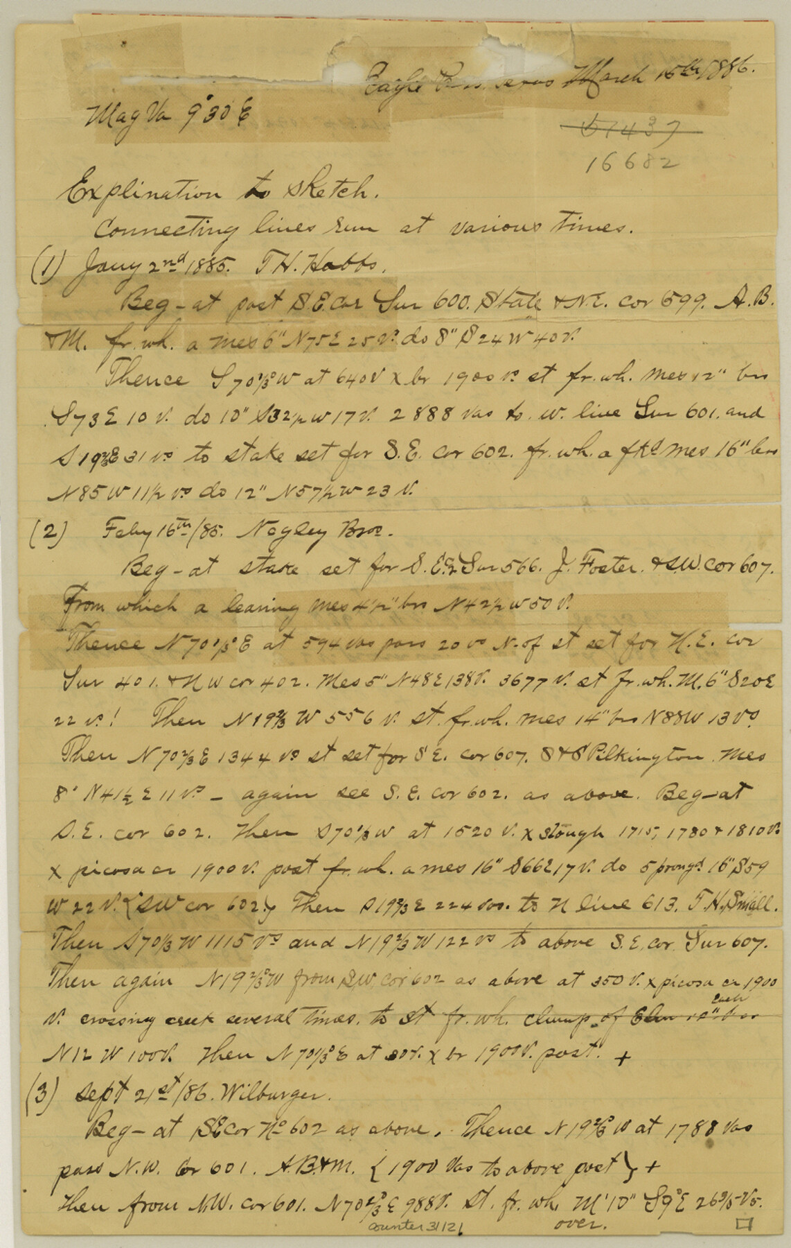
Maverick County Sketch File 18
[Sketch and explanation of area around the S. & S. Pilkington tract in the east part of the county]
-
Map/Doc
31121
-
Collection
General Map Collection
-
Object Dates
3/15/1886 (Creation Date)
7/13/1887 (File Date)
-
People and Organizations
O.H. Hector (Surveyor/Engineer)
E.A. Giraud (Surveyor/Engineer)
-
Counties
Maverick Zavala
-
Subjects
Surveying Sketch File
-
Height x Width
12.8 x 8.1 inches
32.5 x 20.6 cm
-
Medium
paper, manuscript
-
Features
Picosa Creek
Part of: General Map Collection
Kimble County Sketch File 8

Print $14.00
- Digital $50.00
Kimble County Sketch File 8
1847
Size 7.7 x 7.0 inches
Map/Doc 28920
Hamilton County Boundary File 1a

Print $40.00
- Digital $50.00
Hamilton County Boundary File 1a
Size 36.1 x 8.6 inches
Map/Doc 54193
Fannin County Sketch File 2

Print $4.00
- Digital $50.00
Fannin County Sketch File 2
1853
Size 12.4 x 7.9 inches
Map/Doc 22445
Panola County Working Sketch 37

Print $20.00
- Digital $50.00
Panola County Working Sketch 37
1984
Map/Doc 71446
Map of the United States and their Territories between the Mississippi and the Pacific Ocean and part of Mexico

Print $20.00
- Digital $50.00
Map of the United States and their Territories between the Mississippi and the Pacific Ocean and part of Mexico
1858
Size 23.5 x 26.5 inches
Map/Doc 96526
Colorado County Sketch File 32

Print $4.00
- Digital $50.00
Colorado County Sketch File 32
1847
Size 13.0 x 8.4 inches
Map/Doc 18986
Zavala County Sketch File 14

Print $26.00
- Digital $50.00
Zavala County Sketch File 14
1887
Size 14.4 x 8.7 inches
Map/Doc 41308
Galveston County NRC Article 33.136 Sketch 23

Print $22.00
- Digital $50.00
Galveston County NRC Article 33.136 Sketch 23
2002
Size 11.4 x 16.4 inches
Map/Doc 81905
Bandera County Working Sketch 37

Print $20.00
- Digital $50.00
Bandera County Working Sketch 37
1970
Size 23.6 x 25.0 inches
Map/Doc 67633
Midland County Rolled Sketch REE

Print $20.00
- Digital $50.00
Midland County Rolled Sketch REE
1937
Size 27.1 x 24.3 inches
Map/Doc 6771
Mills County Boundary File 6

Print $2.00
- Digital $50.00
Mills County Boundary File 6
Size 11.0 x 8.6 inches
Map/Doc 57311
[Aransas Bay]
![72970, [Aransas Bay], General Map Collection](https://historictexasmaps.com/wmedia_w700/maps/72970.tif.jpg)
Print $20.00
- Digital $50.00
[Aransas Bay]
1846
Size 24.3 x 18.3 inches
Map/Doc 72970
You may also like
Township No. 5 South Range No. 9 West of the Indian Meridian

Print $20.00
- Digital $50.00
Township No. 5 South Range No. 9 West of the Indian Meridian
1874
Size 19.2 x 24.5 inches
Map/Doc 75135
[Report showing connections and corners made on ground in south part of Yoakum County and north part of Gaines County, Texas]

[Report showing connections and corners made on ground in south part of Yoakum County and north part of Gaines County, Texas]
1938
Size 8.1 x 10.9 inches
Map/Doc 93256
Goliad County Sketch File 28

Print $20.00
- Digital $50.00
Goliad County Sketch File 28
Size 18.9 x 15.5 inches
Map/Doc 11569
Harbor of Brazos Santiago, Texas

Print $20.00
- Digital $50.00
Harbor of Brazos Santiago, Texas
1887
Size 27.1 x 18.3 inches
Map/Doc 72998
Rio Grande, Harlingen Sheet

Print $20.00
- Digital $50.00
Rio Grande, Harlingen Sheet
1935
Size 37.2 x 37.2 inches
Map/Doc 65113
J. B. Chilton's Subdivision of League 289, Gaines County, Texas

Print $20.00
- Digital $50.00
J. B. Chilton's Subdivision of League 289, Gaines County, Texas
1924
Size 18.7 x 24.7 inches
Map/Doc 92682

Fractional Township No. 7 South Range No. 1 West of the Indian Meridian, Indian Territory

Print $20.00
- Digital $50.00
Fractional Township No. 7 South Range No. 1 West of the Indian Meridian, Indian Territory
1898
Size 19.2 x 24.4 inches
Map/Doc 75197
Liberty County Working Sketch 78

Print $20.00
- Digital $50.00
Liberty County Working Sketch 78
1981
Size 36.2 x 41.0 inches
Map/Doc 70538
Baylor County Rolled Sketch 10

Print $20.00
- Digital $50.00
Baylor County Rolled Sketch 10
Size 28.0 x 14.0 inches
Map/Doc 5127
Railroad Track Map, H&TCRRCo., Falls County, Texas

Print $4.00
- Digital $50.00
Railroad Track Map, H&TCRRCo., Falls County, Texas
1918
Size 11.7 x 18.4 inches
Map/Doc 62862
Brazos Santiago, Texas

Print $20.00
- Digital $50.00
Brazos Santiago, Texas
1900
Size 18.3 x 26.8 inches
Map/Doc 73033