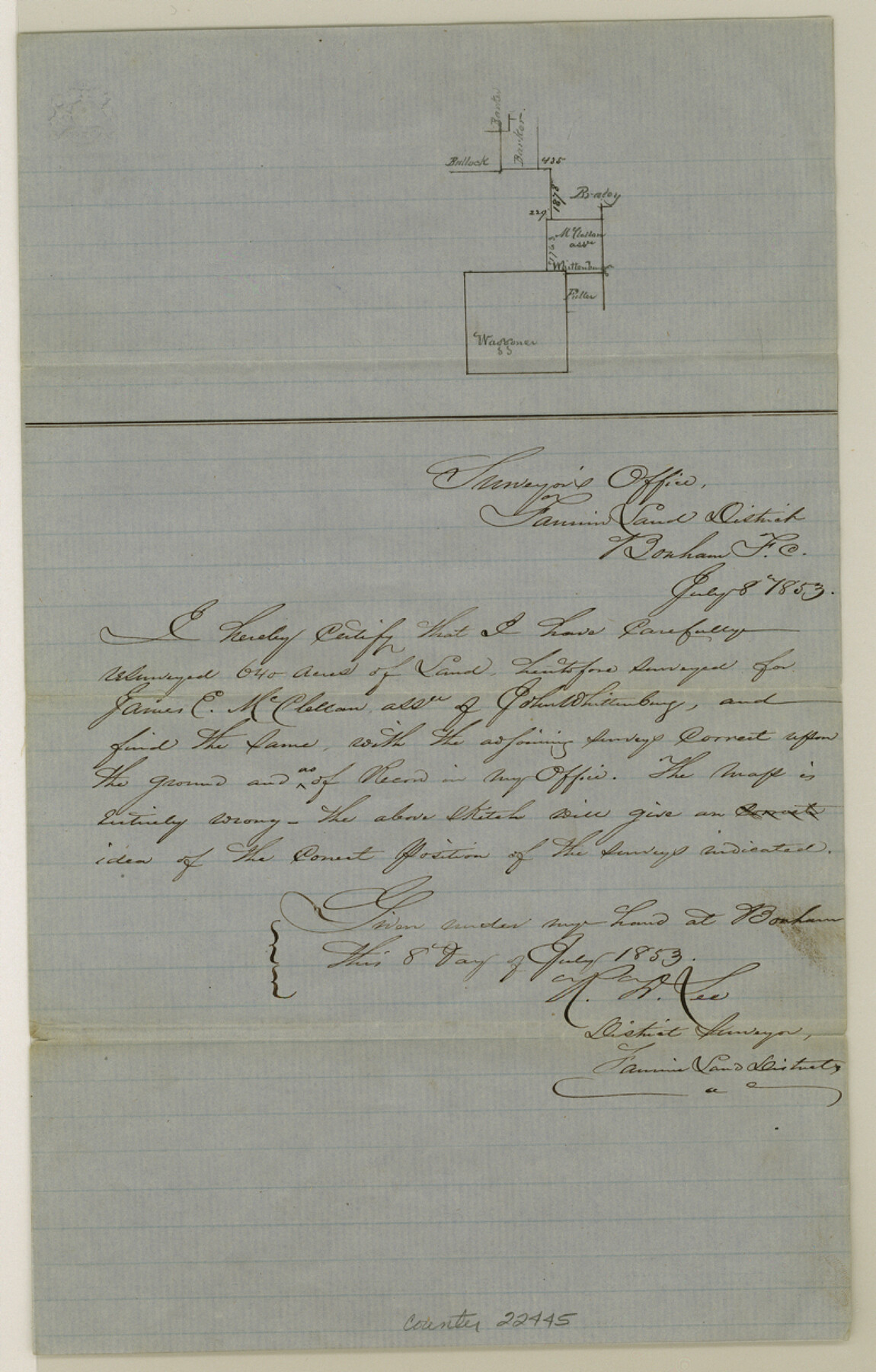
Fannin County Sketch File 2
[Sketch of surveys on the headwaters of North Sulphur]
-
Map/Doc
22445
-
Collection
General Map Collection
-
Object Dates
1853/6/8 (Creation Date)
1853/6/27 (File Date)
-
People and Organizations
R.D. Lee (Surveyor/Engineer)
-
Counties
Fannin
-
Subjects
Surveying Sketch File
-
Height x Width
12.4 x 7.9 inches
31.5 x 20.1 cm
-
Medium
paper, manuscript
-
Features
[North Sulphur River]
Part of: General Map Collection
Little River, Buckholts Sheet

Print $4.00
- Digital $50.00
Little River, Buckholts Sheet
1936
Size 30.0 x 24.2 inches
Map/Doc 65065
Colorado County Sketch File 19

Print $4.00
- Digital $50.00
Colorado County Sketch File 19
Size 9.1 x 7.5 inches
Map/Doc 18952
Stonewall County Rolled Sketch 9

Print $20.00
- Digital $50.00
Stonewall County Rolled Sketch 9
Size 35.8 x 30.8 inches
Map/Doc 7865
Flight Mission No. CLL-1N, Frame 158, Willacy County

Print $20.00
- Digital $50.00
Flight Mission No. CLL-1N, Frame 158, Willacy County
1954
Size 18.4 x 22.1 inches
Map/Doc 87049
Bell County Sketch File 12

Print $4.00
- Digital $50.00
Bell County Sketch File 12
1852
Size 8.1 x 12.5 inches
Map/Doc 14385
Brazos River, Brazos River Sheet 4

Print $6.00
- Digital $50.00
Brazos River, Brazos River Sheet 4
1926
Size 19.7 x 32.0 inches
Map/Doc 65297
Edwards County Working Sketch 139

Print $20.00
- Digital $50.00
Edwards County Working Sketch 139
Size 20.9 x 21.4 inches
Map/Doc 62184
Salina Road, Hays' District, Nacogdoches County

Print $2.00
- Digital $50.00
Salina Road, Hays' District, Nacogdoches County
Size 5.1 x 6.2 inches
Map/Doc 174
Tarrant County Sketch File 15

Print $4.00
- Digital $50.00
Tarrant County Sketch File 15
1859
Size 13.2 x 8.1 inches
Map/Doc 37708
Sutton County Working Sketch 17

Print $20.00
- Digital $50.00
Sutton County Working Sketch 17
1975
Size 34.0 x 27.2 inches
Map/Doc 62360

Duval County Sketch File 32b

Print $6.00
- Digital $50.00
Duval County Sketch File 32b
Size 14.2 x 8.9 inches
Map/Doc 21339
You may also like
Map of Maryland, Virginia, North Carolina and South Carolina

Print $20.00
- Digital $50.00
Map of Maryland, Virginia, North Carolina and South Carolina
1885
Size 12.2 x 9.0 inches
Map/Doc 93517
Kent County Working Sketch 15

Print $40.00
- Digital $50.00
Kent County Working Sketch 15
1971
Size 32.3 x 48.3 inches
Map/Doc 70022
Taylor County Sketch File 1a

Print $4.00
- Digital $50.00
Taylor County Sketch File 1a
Size 9.0 x 14.2 inches
Map/Doc 37776
Flight Mission No. BRA-7M, Frame 134, Jefferson County

Print $20.00
- Digital $50.00
Flight Mission No. BRA-7M, Frame 134, Jefferson County
1953
Size 18.6 x 22.5 inches
Map/Doc 85528
Brewster County Working Sketch 33

Print $20.00
- Digital $50.00
Brewster County Working Sketch 33
1943
Size 32.5 x 38.2 inches
Map/Doc 67567
Culberson County Sketch File WJ

Print $8.00
- Digital $50.00
Culberson County Sketch File WJ
Size 14.2 x 28.2 inches
Map/Doc 5786
Zapata County Rolled Sketch 21

Print $155.00
- Digital $50.00
Zapata County Rolled Sketch 21
Size 10.4 x 15.2 inches
Map/Doc 49589
Hood County Sketch File 24

Print $8.00
- Digital $50.00
Hood County Sketch File 24
1942
Size 11.0 x 9.0 inches
Map/Doc 26619
[Office Sketch Showing Surveys North of Loma Blanca Grant, Brooks County, Texas]
![412, [Office Sketch Showing Surveys North of Loma Blanca Grant, Brooks County, Texas], Maddox Collection](https://historictexasmaps.com/wmedia_w700/maps/0412.tif.jpg)
Print $20.00
- Digital $50.00
[Office Sketch Showing Surveys North of Loma Blanca Grant, Brooks County, Texas]
Size 16.6 x 19.6 inches
Map/Doc 412
El Paso County Rolled Sketch Z51

Print $40.00
- Digital $50.00
El Paso County Rolled Sketch Z51
1915
Size 37.2 x 49.0 inches
Map/Doc 8868
Flight Mission No. CUG-3P, Frame 35, Kleberg County

Print $20.00
- Digital $50.00
Flight Mission No. CUG-3P, Frame 35, Kleberg County
1956
Size 18.6 x 22.3 inches
Map/Doc 86240
Waller County, Texas

Print $20.00
- Digital $50.00
Waller County, Texas
1879
Size 22.8 x 17.7 inches
Map/Doc 764