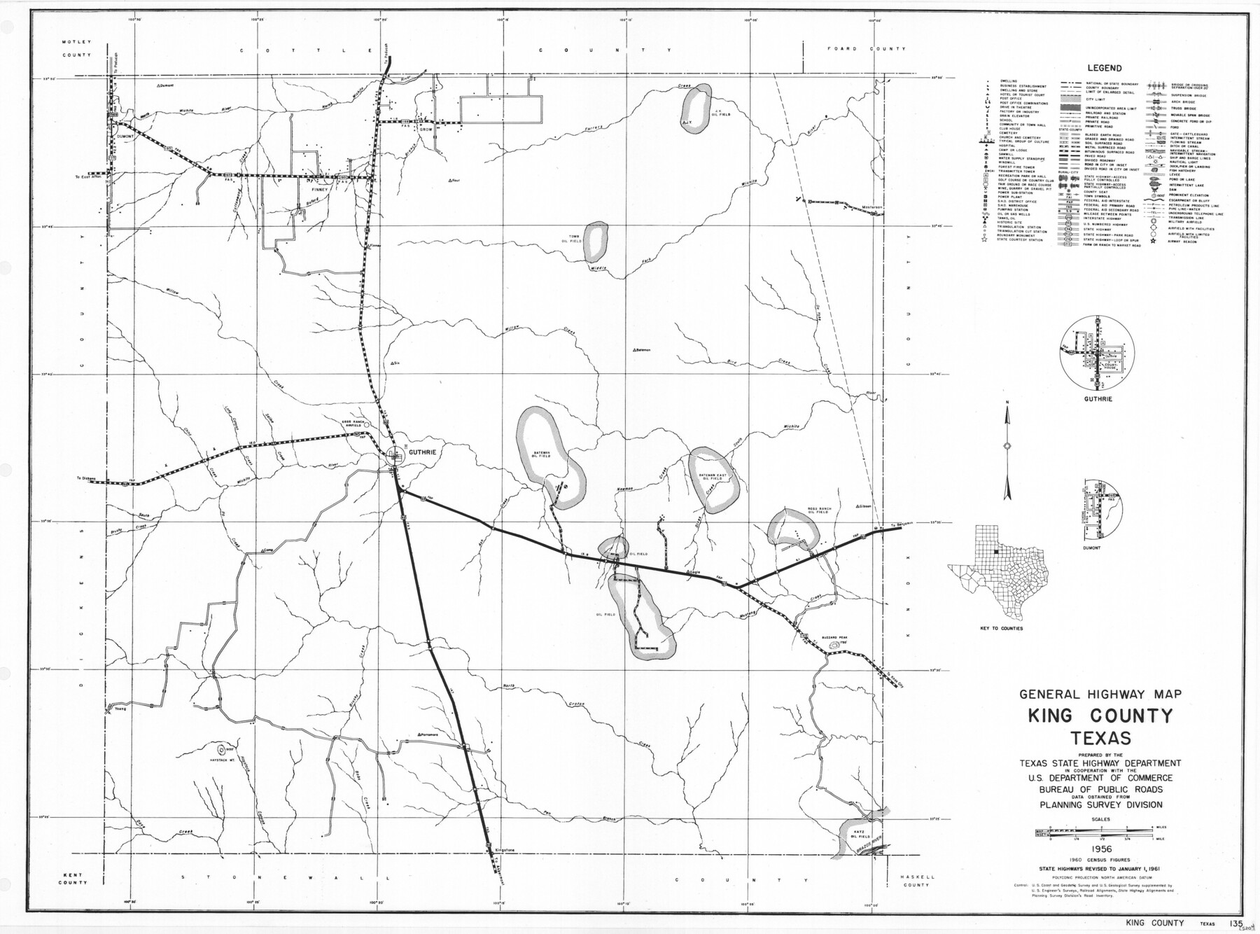
General Highway Map, King County, Texas
-
Map/Doc
79555
-
Collection
Texas State Library and Archives
-
Object Dates
1961 (Creation Date)
-
People and Organizations
Texas State Highway Department (Publisher)
-
Counties
King
-
Subjects
County
-
Height x Width
18.2 x 24.6 inches
46.2 x 62.5 cm
-
Comments
Prints available courtesy of the Texas State Library and Archives.
More info can be found here: TSLAC Map 05204
Part of: Texas State Library and Archives
General Highway Map, Gonzales County, Texas

Print $20.00
General Highway Map, Gonzales County, Texas
1961
Size 18.2 x 24.7 inches
Map/Doc 79482
Official Railroad and County Map of Texas

Print $40.00
Official Railroad and County Map of Texas
1914
Size 45.8 x 48.6 inches
Map/Doc 76233
General Highway Map, Kleberg County, Texas

Print $20.00
General Highway Map, Kleberg County, Texas
1940
Size 24.9 x 18.4 inches
Map/Doc 79165
General Highway Map. Detail of Cities and Towns in Dallas County, Texas [Dallas and vicinity]
![79435, General Highway Map. Detail of Cities and Towns in Dallas County, Texas [Dallas and vicinity], Texas State Library and Archives](https://historictexasmaps.com/wmedia_w700/maps/79435.tif.jpg)
Print $20.00
General Highway Map. Detail of Cities and Towns in Dallas County, Texas [Dallas and vicinity]
1961
Size 18.2 x 24.6 inches
Map/Doc 79435
General Highway Map, El Paso County, Texas

Print $20.00
General Highway Map, El Paso County, Texas
1961
Size 18.2 x 24.6 inches
Map/Doc 79459
General Highway Map, Hood County, Somervell County, Texas

Print $20.00
General Highway Map, Hood County, Somervell County, Texas
1940
Size 18.3 x 24.8 inches
Map/Doc 79131
General Highway Map, Edwards County, Real County, Texas

Print $20.00
General Highway Map, Edwards County, Real County, Texas
1961
Size 18.1 x 24.7 inches
Map/Doc 79452
General Highway Map, El Paso County, Texas

Print $20.00
General Highway Map, El Paso County, Texas
1961
Size 18.1 x 24.7 inches
Map/Doc 79457
General Highway Map, Guadalupe County, Texas

Print $20.00
General Highway Map, Guadalupe County, Texas
1940
Size 18.6 x 25.1 inches
Map/Doc 79107
General Highway Map, Williamson County, Texas

Print $20.00
General Highway Map, Williamson County, Texas
1961
Size 24.8 x 18.2 inches
Map/Doc 79712
General Highway Map. Detail of Cities and Towns in Tarrant County, Texas. City Map, Fort Worth and vicinity, Tarrant County, Texas

Print $20.00
General Highway Map. Detail of Cities and Towns in Tarrant County, Texas. City Map, Fort Worth and vicinity, Tarrant County, Texas
1961
Size 18.2 x 24.9 inches
Map/Doc 79667
General Highway Map, Hutchinson County, Texas

Print $20.00
General Highway Map, Hutchinson County, Texas
1961
Size 18.1 x 24.6 inches
Map/Doc 79529
You may also like
Mitchell County Sketch File 12

Print $20.00
- Digital $50.00
Mitchell County Sketch File 12
1912
Size 25.6 x 14.0 inches
Map/Doc 12099
San Saba County Working Sketch 8

Print $20.00
- Digital $50.00
San Saba County Working Sketch 8
1979
Size 13.3 x 17.2 inches
Map/Doc 63796
Mitchell County

Print $20.00
- Digital $50.00
Mitchell County
1889
Size 42.3 x 35.7 inches
Map/Doc 10792
Pecos County Working Sketch 73

Print $40.00
- Digital $50.00
Pecos County Working Sketch 73
1957
Size 110.6 x 38.7 inches
Map/Doc 71545

General Highway Map, Foard County, Texas

Print $20.00
General Highway Map, Foard County, Texas
1940
Size 18.6 x 25.2 inches
Map/Doc 79092
Val Verde County Working Sketch 18

Print $20.00
- Digital $50.00
Val Verde County Working Sketch 18
1928
Size 31.4 x 28.3 inches
Map/Doc 72153
San Saba County Sketch File 10

Print $20.00
- Digital $50.00
San Saba County Sketch File 10
1883
Size 20.4 x 16.5 inches
Map/Doc 12290
Montgomery County Sketch File 18

Print $20.00
- Digital $50.00
Montgomery County Sketch File 18
1899
Size 22.1 x 19.6 inches
Map/Doc 42122
Howard County Sketch File A

Print $44.00
- Digital $50.00
Howard County Sketch File A
Size 7.2 x 7.6 inches
Map/Doc 26837
[Right of Way & Track Map, The Texas & Pacific Ry. Co. Main Line]
![64672, [Right of Way & Track Map, The Texas & Pacific Ry. Co. Main Line], General Map Collection](https://historictexasmaps.com/wmedia_w700/maps/64672.tif.jpg)
Print $20.00
- Digital $50.00
[Right of Way & Track Map, The Texas & Pacific Ry. Co. Main Line]
Size 11.0 x 18.4 inches
Map/Doc 64672
Hale County Sketch File 3

Print $4.00
- Digital $50.00
Hale County Sketch File 3
1888
Size 8.6 x 12.7 inches
Map/Doc 24723