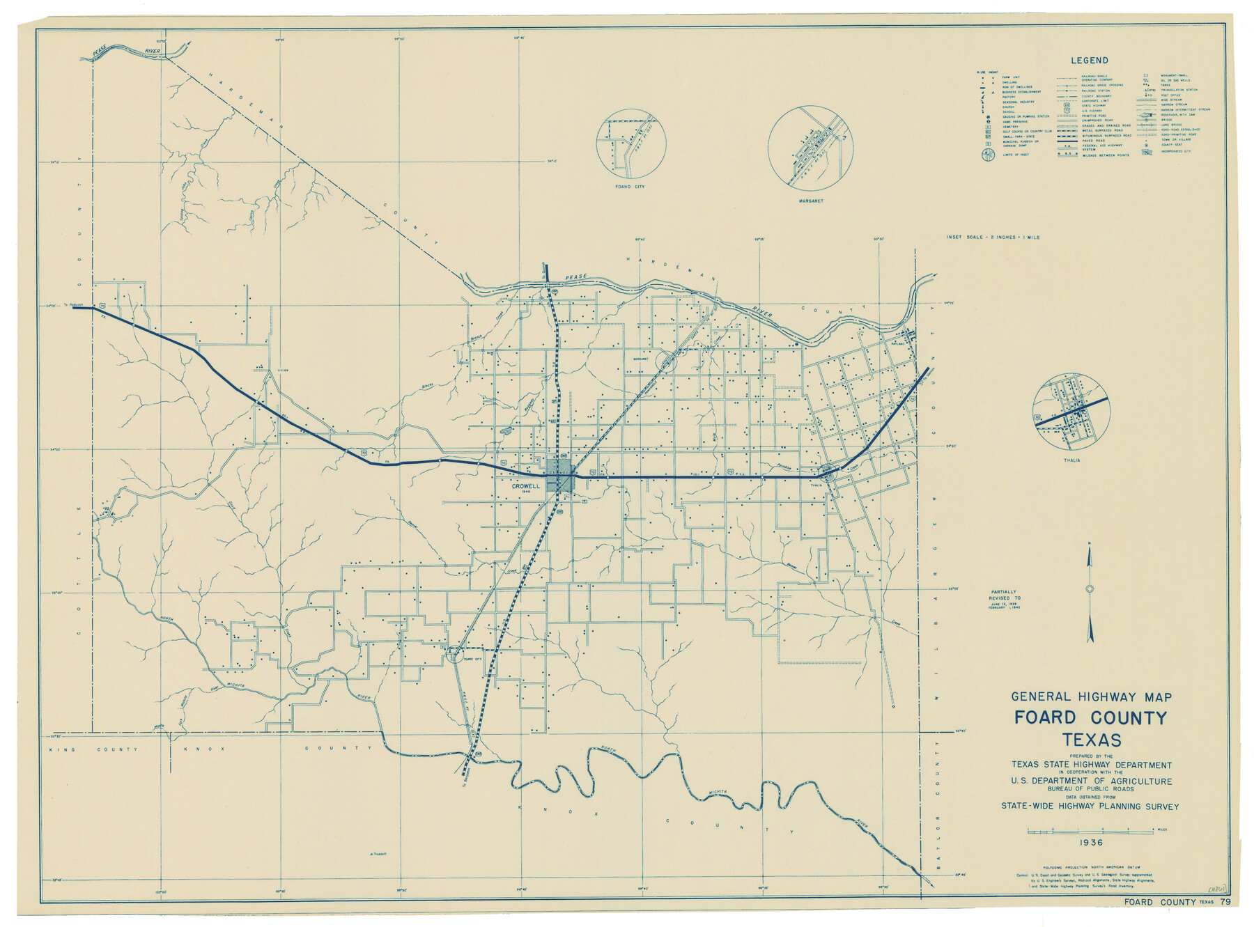
General Highway Map, Foard County, Texas
-
Map/Doc
79092
-
Collection
Texas State Library and Archives
-
Object Dates
1940 (Creation Date)
-
People and Organizations
Texas State Highway Department (Publisher)
-
Counties
Foard
-
Subjects
County
-
Height x Width
18.6 x 25.2 inches
47.2 x 64.0 cm
-
Comments
Prints available courtesy of the Texas State Library and Archives.
More info can be found here: TSLAC Map 04861
Part of: Texas State Library and Archives
Carte du Mexique ou de la Nouvelle Espagne

Print $20.00
Carte du Mexique ou de la Nouvelle Espagne
1750
Size 12.4 x 15.5 inches
Map/Doc 79741
General Highway Map, Crosby County, Texas

Print $20.00
General Highway Map, Crosby County, Texas
1940
Size 18.3 x 25.1 inches
Map/Doc 79063
General Highway Map. Detail of Cities and Towns in Jim Wells County, Texas. City Map of Alice, Jim Wells County, Texas

Print $20.00
General Highway Map. Detail of Cities and Towns in Jim Wells County, Texas. City Map of Alice, Jim Wells County, Texas
1961
Size 24.6 x 18.3 inches
Map/Doc 79544
General Highway Map, Frio County, Texas

Print $20.00
General Highway Map, Frio County, Texas
1961
Size 18.2 x 24.5 inches
Map/Doc 79473
General Highway Map. Detail of Cities and Towns in Travis County, Texas. City Map, Austin and vicinity, Travis County, Texas

Print $20.00
General Highway Map. Detail of Cities and Towns in Travis County, Texas. City Map, Austin and vicinity, Travis County, Texas
1961
Size 18.1 x 24.7 inches
Map/Doc 79687
General Highway Map, Crockett County, Texas

Print $20.00
General Highway Map, Crockett County, Texas
1961
Size 18.1 x 24.6 inches
Map/Doc 79425
General Highway Map, Pecos County, Texas

Print $20.00
General Highway Map, Pecos County, Texas
1940
Size 24.6 x 18.3 inches
Map/Doc 79217
The Federal Aid Highway System Progress Map

Print $20.00
The Federal Aid Highway System Progress Map
1931
Size 31.4 x 22.1 inches
Map/Doc 79745
Map of the Republic of Texas and the Adjacent Territories, Indicating the Grants of Land Conceded under the Empresario System of Mexico

Print $20.00
Map of the Republic of Texas and the Adjacent Territories, Indicating the Grants of Land Conceded under the Empresario System of Mexico
1841
Size 13.4 x 16.7 inches
Map/Doc 76244
General Highway Map, Camp County, Morris County, Titus County, Texas

Print $20.00
General Highway Map, Camp County, Morris County, Titus County, Texas
1961
Size 24.7 x 18.1 inches
Map/Doc 79400
General Highway Map, Palo Pinto County, Texas

Print $20.00
General Highway Map, Palo Pinto County, Texas
1961
Size 18.3 x 24.4 inches
Map/Doc 79623
General Highway Map, Potter County, Texas

Print $20.00
General Highway Map, Potter County, Texas
1961
Size 24.5 x 18.2 inches
Map/Doc 79631
You may also like
Yoakum County Rolled Sketch 3(2)

Print $40.00
- Digital $50.00
Yoakum County Rolled Sketch 3(2)
1959
Size 12.7 x 128.8 inches
Map/Doc 10163
Rio Grande, Donna Sheet

Print $20.00
- Digital $50.00
Rio Grande, Donna Sheet
1937
Size 37.5 x 37.4 inches
Map/Doc 65117

Matagorda County Sketch File 3

Print $4.00
- Digital $50.00
Matagorda County Sketch File 3
1876
Size 12.9 x 8.0 inches
Map/Doc 30732
Harris County Rolled Sketch 101

Print $20.00
- Digital $50.00
Harris County Rolled Sketch 101
2004
Size 24.3 x 36.2 inches
Map/Doc 83063
Flight Mission No. BRA-8M, Frame 23, Jefferson County

Print $20.00
- Digital $50.00
Flight Mission No. BRA-8M, Frame 23, Jefferson County
1953
Size 18.7 x 22.3 inches
Map/Doc 85578
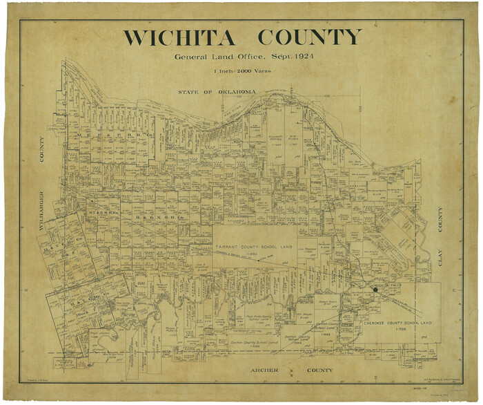
Wichita County
Print $20.00
- Digital $50.00
Wichita County
1924
Size 33.7 x 40.2 inches
Map/Doc 63123
Ochiltree County Boundary File 5c

Print $30.00
- Digital $50.00
Ochiltree County Boundary File 5c
Size 11.2 x 8.7 inches
Map/Doc 57699
[Galveston, Harrisburg & San Antonio through El Paso County]
![64008, [Galveston, Harrisburg & San Antonio through El Paso County], General Map Collection](https://historictexasmaps.com/wmedia_w700/maps/64008.tif.jpg)
Print $20.00
- Digital $50.00
[Galveston, Harrisburg & San Antonio through El Paso County]
1906
Size 13.7 x 33.8 inches
Map/Doc 64008
Val Verde County Working Sketch 67

Print $40.00
- Digital $50.00
Val Verde County Working Sketch 67
1964
Size 48.4 x 42.1 inches
Map/Doc 72202
Waller County Sketch File 1

Print $14.00
- Digital $50.00
Waller County Sketch File 1
Size 8.1 x 6.9 inches
Map/Doc 39563
Lloyd's Map of the Southern States showing all the Railroads, their Stations & Distances, also the Counties, Towns, Villages, Harbors, Rivers, and Forts

Print $40.00
- Digital $50.00
Lloyd's Map of the Southern States showing all the Railroads, their Stations & Distances, also the Counties, Towns, Villages, Harbors, Rivers, and Forts
1861
Size 39.3 x 54.4 inches
Map/Doc 96556