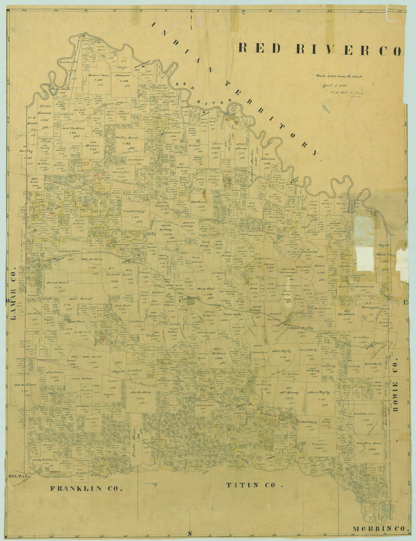
Red River Co.
-
Map/Doc
16796
-
Collection
General Map Collection
-
Object Dates
1897/4/1 (Creation Date)
-
People and Organizations
Texas General Land Office (Publisher)
C.M. Hill (Draftsman)
C.M. Hill (Compiler)
-
Counties
Red River
-
Subjects
County
-
Height x Width
46.8 x 36.0 inches
118.9 x 91.4 cm
-
Comments
Help Save Texas History - Adopt Me!
-
Features
Big Mustang Creek
Kickapoo Creek
Jakes Creek
Cragg's Creek
Boggy Creek
Clapham Creek
White Oak Creek
Douglas
Bagwell
Bennet
Wayland
Cuthand Creek
Heel Tap Creek
Pine Branch of White Oak Creek
Annona
Halesborough
Little Mustang Creek
Plat Creek
Shawnee Creek
East Fork of Caney Creek
Big Slough Lake
Brushy Lake
South Sulphur [Fork of Red River]
Sulphur Fork of Red River
Pine Creek
Mound City
Big Slough
T&P
Grassy Lake
Kiamitia
Jonesborough
Red River
Stringland Lake
Albion
Little Pine Creek
North Fork of Bason's Mill Creek
Bason's Mill Creek
North Fork of Pecan Bayou
Pecan Bayou
White Oak Fork [of Pecan Bayou]
Shawnee Lake
South Fork [of Pecan Bayou]
Caney Creek
Little Creek
Beaver Dam Creek
Wild Cat Creek
Turkey Creek
Wards Creek
Guest Creek
Bruton Creek
Bland's Creek
Clarksville
Mill Creek
Part of: General Map Collection
Orange County Working Sketch 33

Print $20.00
- Digital $50.00
Orange County Working Sketch 33
1957
Size 26.1 x 18.4 inches
Map/Doc 71365
Hutchinson County Rolled Sketch 40

Print $20.00
- Digital $50.00
Hutchinson County Rolled Sketch 40
1981
Size 25.7 x 37.4 inches
Map/Doc 6297
Hutchinson County Working Sketch 26

Print $20.00
- Digital $50.00
Hutchinson County Working Sketch 26
1978
Size 27.5 x 23.4 inches
Map/Doc 66386
Duval County Sketch File 79

Print $46.00
- Digital $50.00
Duval County Sketch File 79
1925
Size 14.3 x 9.1 inches
Map/Doc 21469
Haskell County Sketch File 19

Print $20.00
- Digital $50.00
Haskell County Sketch File 19
1902
Size 26.9 x 23.1 inches
Map/Doc 11742
Flight Mission No. DQN-2K, Frame 30, Calhoun County

Print $20.00
- Digital $50.00
Flight Mission No. DQN-2K, Frame 30, Calhoun County
1953
Size 18.5 x 22.2 inches
Map/Doc 84237
Flight Mission No. DQO-8K, Frame 7, Galveston County

Print $20.00
- Digital $50.00
Flight Mission No. DQO-8K, Frame 7, Galveston County
1952
Size 18.7 x 22.4 inches
Map/Doc 85130
Edwards County Working Sketch 26

Print $20.00
- Digital $50.00
Edwards County Working Sketch 26
1942
Size 31.8 x 28.8 inches
Map/Doc 68902
Flight Mission No. DAG-24K, Frame 150, Matagorda County

Print $20.00
- Digital $50.00
Flight Mission No. DAG-24K, Frame 150, Matagorda County
1953
Size 18.5 x 22.2 inches
Map/Doc 86564
Navarro County Working Sketch 8

Print $20.00
- Digital $50.00
Navarro County Working Sketch 8
1955
Size 17.9 x 19.2 inches
Map/Doc 71238
Borden County Working Sketch 15

Print $20.00
- Digital $50.00
Borden County Working Sketch 15
1984
Size 25.5 x 18.9 inches
Map/Doc 67475
Kimble County Working Sketch 80

Print $20.00
- Digital $50.00
Kimble County Working Sketch 80
1971
Size 32.3 x 24.3 inches
Map/Doc 70148
You may also like
Cottle County Sketch File 1

Print $20.00
- Digital $50.00
Cottle County Sketch File 1
1882
Size 20.7 x 18.9 inches
Map/Doc 11189
San Antonio & Aransas Pass R.R. Right of Way from Eagle Lake to Brazos River

Print $20.00
- Digital $50.00
San Antonio & Aransas Pass R.R. Right of Way from Eagle Lake to Brazos River
1895
Size 29.7 x 13.0 inches
Map/Doc 64257
Cass County Working Sketch 13

Print $20.00
- Digital $50.00
Cass County Working Sketch 13
1945
Size 29.8 x 33.5 inches
Map/Doc 67916
Tarrant County Boundary File 5

Print $104.00
- Digital $50.00
Tarrant County Boundary File 5
Size 11.4 x 8.8 inches
Map/Doc 59161

Map of Goliad County Texas

Print $20.00
- Digital $50.00
Map of Goliad County Texas
1879
Size 19.1 x 21.2 inches
Map/Doc 3589
Burnet County Working Sketch 1

Print $20.00
- Digital $50.00
Burnet County Working Sketch 1
1916
Size 22.4 x 31.9 inches
Map/Doc 67844
Duval County Sketch File 56

Print $20.00
- Digital $50.00
Duval County Sketch File 56
1938
Size 24.1 x 20.1 inches
Map/Doc 11405
![94160, Austin and Vicinity [Recto], General Map Collection](https://historictexasmaps.com/wmedia_w700/maps/94160.tif.jpg)
Frio County Rolled Sketch 16

Print $20.00
- Digital $50.00
Frio County Rolled Sketch 16
1952
Size 38.4 x 40.7 inches
Map/Doc 8906
La Salle County Sketch File 17 and 17 1/2

Print $94.00
- Digital $50.00
La Salle County Sketch File 17 and 17 1/2
Size 8.8 x 8.1 inches
Map/Doc 29489
Flight Mission No. BRE-2P, Frame 98, Nueces County

Print $20.00
- Digital $50.00
Flight Mission No. BRE-2P, Frame 98, Nueces County
1956
Size 18.5 x 22.4 inches
Map/Doc 86783