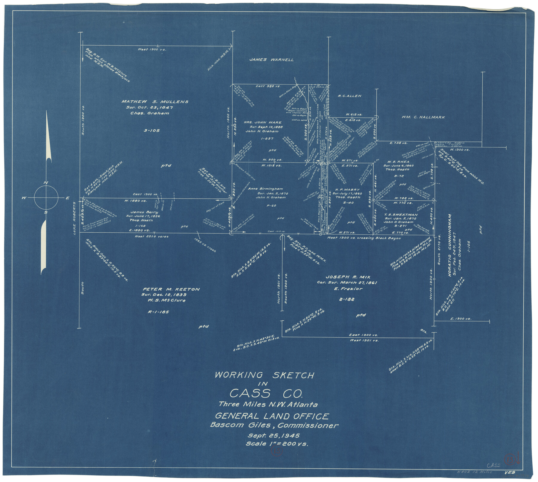
Cass County Working Sketch 13
-
Map/Doc
67916
-
Collection
General Map Collection
-
Object Dates
9/25/1945 (Creation Date)
-
People and Organizations
Victor E. Sterzing (Draftsman)
-
Counties
Cass
-
Subjects
Surveying Working Sketch
-
Height x Width
29.8 x 33.5 inches
75.7 x 85.1 cm
-
Scale
1" = 200 varas
Part of: General Map Collection
[Surveys in the Victoria District along the Guadalupe and Coleto Rivers]
![21, [Surveys in the Victoria District along the Guadalupe and Coleto Rivers], General Map Collection](https://historictexasmaps.com/wmedia_w700/maps/21.tif.jpg)
Print $20.00
- Digital $50.00
[Surveys in the Victoria District along the Guadalupe and Coleto Rivers]
1840
Size 26.0 x 19.6 inches
Map/Doc 21
Lavaca County Working Sketch 6

Print $20.00
- Digital $50.00
Lavaca County Working Sketch 6
1941
Size 20.8 x 22.0 inches
Map/Doc 70359
Brewster County Rolled Sketch 114

Print $20.00
- Digital $50.00
Brewster County Rolled Sketch 114
1964
Size 11.5 x 18.2 inches
Map/Doc 5286
Flight Mission No. DQO-8K, Frame 16, Galveston County

Print $20.00
- Digital $50.00
Flight Mission No. DQO-8K, Frame 16, Galveston County
1952
Size 18.8 x 22.4 inches
Map/Doc 85139
Intracoastal Waterway in Texas - Corpus Christi to Point Isabel including Arroyo Colorado to Mo. Pac. R.R. Bridge Near Harlingen

Print $20.00
- Digital $50.00
Intracoastal Waterway in Texas - Corpus Christi to Point Isabel including Arroyo Colorado to Mo. Pac. R.R. Bridge Near Harlingen
1933
Size 27.5 x 40.6 inches
Map/Doc 61869
Louisiana and Texas Intracoastal Waterway, Section 7, Galveston Bay to Brazos River and Section 8, Brazos River to Matagorda Bay

Print $20.00
- Digital $50.00
Louisiana and Texas Intracoastal Waterway, Section 7, Galveston Bay to Brazos River and Section 8, Brazos River to Matagorda Bay
1928
Size 30.7 x 42.9 inches
Map/Doc 61840
Liberty County Rolled Sketch T

Print $20.00
- Digital $50.00
Liberty County Rolled Sketch T
1941
Size 20.8 x 16.0 inches
Map/Doc 6626
Right of Way & Track Map, St. Louis, Brownsville & Mexico Ry. operated by St. Louis, Brownsville & Mexico Ry. Co.

Print $40.00
- Digital $50.00
Right of Way & Track Map, St. Louis, Brownsville & Mexico Ry. operated by St. Louis, Brownsville & Mexico Ry. Co.
1919
Size 25.8 x 56.9 inches
Map/Doc 64620
Harris County Rolled Sketch 94

Print $20.00
- Digital $50.00
Harris County Rolled Sketch 94
1985
Size 33.8 x 18.4 inches
Map/Doc 6133
Montgomery County Working Sketch 41

Print $20.00
- Digital $50.00
Montgomery County Working Sketch 41
1955
Size 22.9 x 23.6 inches
Map/Doc 71148
Parker County Working Sketch 2

Print $20.00
- Digital $50.00
Parker County Working Sketch 2
1920
Map/Doc 71452
Travis County Working Sketch 46

Print $20.00
- Digital $50.00
Travis County Working Sketch 46
1981
Size 46.6 x 36.9 inches
Map/Doc 69430
You may also like
[Plat Showing Colorado, Upshur & Travis County School Land and Surrounding Area in Baylor & Throckmorton Counties, Texas]
![75790, [Plat Showing Colorado, Upshur & Travis County School Land and Surrounding Area in Baylor & Throckmorton Counties, Texas], Maddox Collection](https://historictexasmaps.com/wmedia_w700/maps/75790.tif.jpg)
Print $20.00
- Digital $50.00
[Plat Showing Colorado, Upshur & Travis County School Land and Surrounding Area in Baylor & Throckmorton Counties, Texas]
1889
Size 15.8 x 20.5 inches
Map/Doc 75790
Map of Henderson County

Print $20.00
- Digital $50.00
Map of Henderson County
1871
Size 16.0 x 31.4 inches
Map/Doc 3665
Armstrong County Sketch File A-13

Print $40.00
- Digital $50.00
Armstrong County Sketch File A-13
Size 12.8 x 17.7 inches
Map/Doc 13714
Randall County Rolled Sketch 9B

Print $20.00
- Digital $50.00
Randall County Rolled Sketch 9B
1985
Size 45.0 x 34.5 inches
Map/Doc 9810
Flight Mission No. CUG-1P, Frame 164, Kleberg County

Print $20.00
- Digital $50.00
Flight Mission No. CUG-1P, Frame 164, Kleberg County
1956
Size 18.5 x 22.2 inches
Map/Doc 86171
[Sketch showing B. H. Epperson, Mary Fury and H. Rodgers surveys and vicinity]
![93069, [Sketch showing B. H. Epperson, Mary Fury and H. Rodgers surveys and vicinity], Twichell Survey Records](https://historictexasmaps.com/wmedia_w700/maps/93069-1.tif.jpg)
Print $20.00
- Digital $50.00
[Sketch showing B. H. Epperson, Mary Fury and H. Rodgers surveys and vicinity]
1919
Size 10.7 x 21.5 inches
Map/Doc 93069
Amistad International Reservoir on Rio Grande 103

Print $20.00
- Digital $50.00
Amistad International Reservoir on Rio Grande 103
1950
Size 28.5 x 41.1 inches
Map/Doc 75534
Burleson County Working Sketch 13

Print $40.00
- Digital $50.00
Burleson County Working Sketch 13
1980
Size 49.2 x 34.6 inches
Map/Doc 67732
Map of the United States to accompany Granger's Southern and Western Texas Guide

Print $20.00
Map of the United States to accompany Granger's Southern and Western Texas Guide
1878
Size 26.4 x 20.4 inches
Map/Doc 76236
Flight Mission No. DCL-7C, Frame 117, Kenedy County

Print $20.00
- Digital $50.00
Flight Mission No. DCL-7C, Frame 117, Kenedy County
1943
Size 18.4 x 22.3 inches
Map/Doc 86082
Wheeler County Sketch File 11

Print $47.00
- Digital $50.00
Wheeler County Sketch File 11
1992
Size 11.5 x 9.0 inches
Map/Doc 40014
Jasper County Rolled Sketch 1

Print $20.00
- Digital $50.00
Jasper County Rolled Sketch 1
Size 11.1 x 18.0 inches
Map/Doc 6347