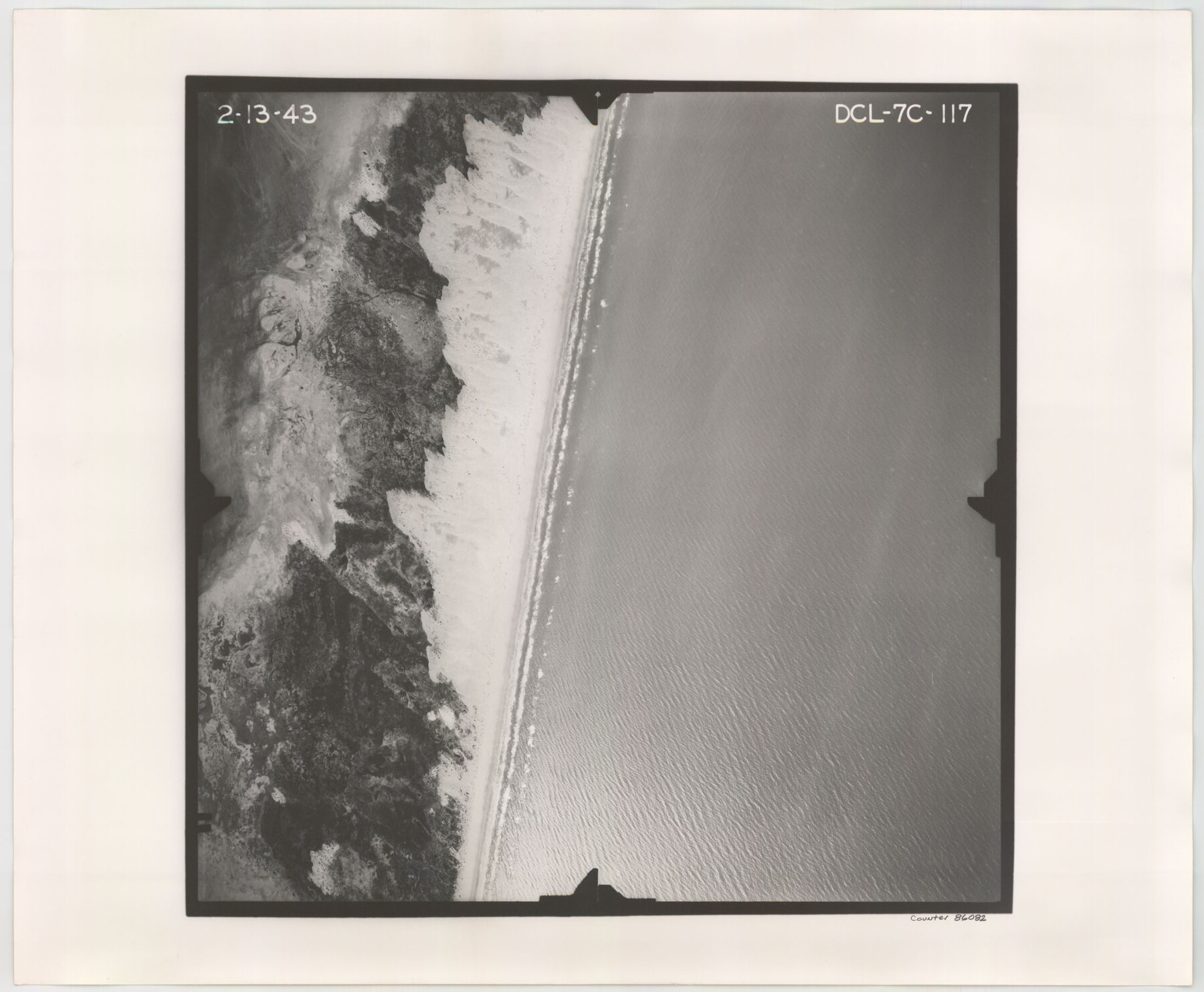
Flight Mission No. DCL-7C, Frame 117, Kenedy County
DCL-7C-117
-
Map/Doc
86082
-
Collection
General Map Collection
-
Object Dates
1943/2/13 (Creation Date)
-
People and Organizations
U. S. Department of Agriculture (Publisher)
-
Counties
Kenedy
-
Subjects
Aerial Photograph
-
Height x Width
18.4 x 22.3 inches
46.7 x 56.6 cm
-
Comments
Flown by Aerial Surveys of Pittsburgh, Inc. of Pittsburgh, Pennsylvania.
Part of: General Map Collection
Matagorda County Sketch File 21

Print $6.00
- Digital $50.00
Matagorda County Sketch File 21
1897
Size 14.2 x 8.7 inches
Map/Doc 30782
Representation of surveys on the waters of the Paluxy and Bosque in the crosstimbers in Milam District

Print $2.00
- Digital $50.00
Representation of surveys on the waters of the Paluxy and Bosque in the crosstimbers in Milam District
1847
Size 13.9 x 8.0 inches
Map/Doc 258
[Map of Texas and Indian Territory]
![93757, [Map of Texas and Indian Territory], General Map Collection](https://historictexasmaps.com/wmedia_w700/maps/93757-1.tif.jpg)
Print $20.00
- Digital $50.00
[Map of Texas and Indian Territory]
1878
Size 26.2 x 20.1 inches
Map/Doc 93757
Cherokee County Working Sketch 27

Print $40.00
- Digital $50.00
Cherokee County Working Sketch 27
1982
Size 42.9 x 59.1 inches
Map/Doc 67982
Brazoria County NRC Article 33.136 Sketch 10

Print $23.00
- Digital $50.00
Brazoria County NRC Article 33.136 Sketch 10
2007
Size 25.7 x 35.7 inches
Map/Doc 87933
Montgomery County Rolled Sketch 40

Print $393.00
- Digital $50.00
Montgomery County Rolled Sketch 40
1970
Size 10.3 x 16.0 inches
Map/Doc 46793
Right of Way and Track Map, the Missouri, Kansas and Texas Ry. of Texas operated by the Missouri, Kansas and Texas Ry. of Texas, San Antonio Division

Print $40.00
- Digital $50.00
Right of Way and Track Map, the Missouri, Kansas and Texas Ry. of Texas operated by the Missouri, Kansas and Texas Ry. of Texas, San Antonio Division
1918
Size 25.2 x 58.8 inches
Map/Doc 64584
Zavala County

Print $40.00
- Digital $50.00
Zavala County
1977
Size 43.9 x 49.2 inches
Map/Doc 73334
Val Verde County Sketch File Z5

Print $20.00
- Digital $50.00
Val Verde County Sketch File Z5
Size 32.3 x 26.1 inches
Map/Doc 12551
Harbor of Brazos Santiago, Texas

Print $20.00
- Digital $50.00
Harbor of Brazos Santiago, Texas
1887
Size 27.0 x 18.3 inches
Map/Doc 72993
Flight Mission No. CRC-1R, Frame 157, Chambers County

Print $20.00
- Digital $50.00
Flight Mission No. CRC-1R, Frame 157, Chambers County
1956
Size 18.8 x 22.5 inches
Map/Doc 84719
Uvalde County Working Sketch 56

Print $20.00
- Digital $50.00
Uvalde County Working Sketch 56
1985
Size 44.8 x 40.6 inches
Map/Doc 72126
You may also like
Williamson County Rolled Sketch 8

Print $20.00
- Digital $50.00
Williamson County Rolled Sketch 8
Size 15.1 x 18.0 inches
Map/Doc 8265
Brazos River Conservation and Reclamation District Official Boundary Line Survey

Print $20.00
- Digital $50.00
Brazos River Conservation and Reclamation District Official Boundary Line Survey
1931
Size 25.1 x 36.9 inches
Map/Doc 90125
Webb County Sketch File 11a-1

Print $27.00
- Digital $50.00
Webb County Sketch File 11a-1
1884
Size 22.2 x 9.3 inches
Map/Doc 12626
Ward County Working Sketch 10

Print $20.00
- Digital $50.00
Ward County Working Sketch 10
1946
Size 29.6 x 15.6 inches
Map/Doc 72316
Coke County Working Sketch 26
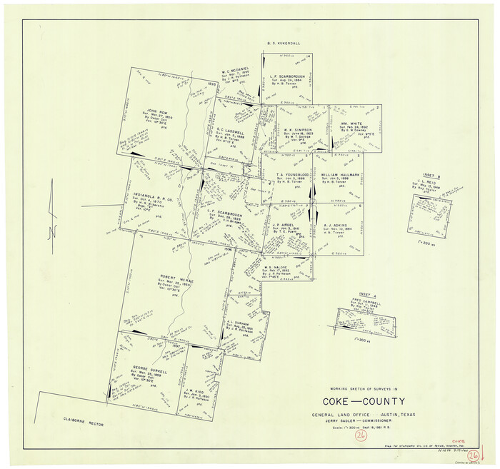
Print $20.00
- Digital $50.00
Coke County Working Sketch 26
1961
Size 29.1 x 31.2 inches
Map/Doc 68063
Flight Mission No. BRE-2P, Frame 39, Nueces County

Print $20.00
- Digital $50.00
Flight Mission No. BRE-2P, Frame 39, Nueces County
1956
Size 18.6 x 22.4 inches
Map/Doc 86741
Coast Chart No. 210 Aransas Pass and Corpus Christi Bay with the coast to latitude 27° 12' Texas

Print $20.00
- Digital $50.00
Coast Chart No. 210 Aransas Pass and Corpus Christi Bay with the coast to latitude 27° 12' Texas
1913
Size 27.9 x 18.3 inches
Map/Doc 72805
Hardeman County Working Sketch 12

Print $40.00
- Digital $50.00
Hardeman County Working Sketch 12
1963
Size 31.2 x 54.3 inches
Map/Doc 63393
Travis County Sketch File 51

Print $8.00
- Digital $50.00
Travis County Sketch File 51
1941
Size 14.3 x 8.9 inches
Map/Doc 38387
McMullen County

Print $40.00
- Digital $50.00
McMullen County
1967
Size 50.8 x 35.8 inches
Map/Doc 95586
Archer County Sketch File 8b

Print $42.00
- Digital $50.00
Archer County Sketch File 8b
1890
Map/Doc 88497
Terrell County Sketch File 35

Print $36.00
- Digital $50.00
Terrell County Sketch File 35
1957
Size 32.0 x 37.6 inches
Map/Doc 10389