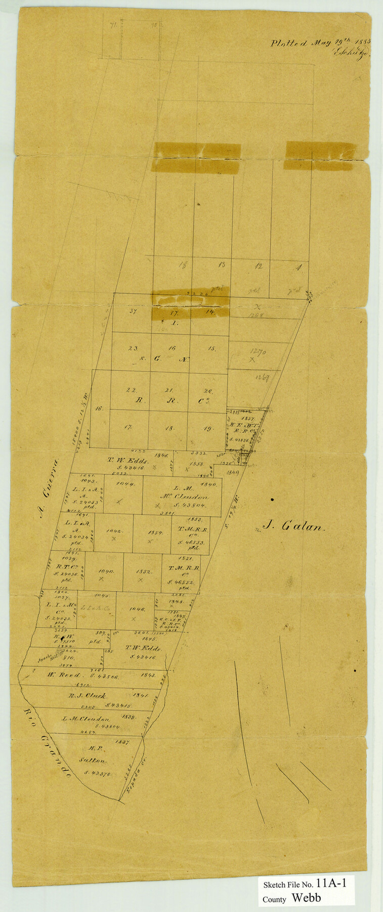
Webb County Sketch File 11a-1
[Protest regarding surveys 809, 810, and 1845 with draftsman's sketch of the area]
-
Map/Doc
12626
-
Collection
General Map Collection
-
Object Dates
9/17/1884 (Creation Date)
5/19/1885 (File Date)
-
People and Organizations
E. Schutze (Draftsman)
A. Brune (Author)
-
Counties
Webb
-
Subjects
Surveying Sketch File
-
Height x Width
22.2 x 9.3 inches
56.4 x 23.6 cm
-
Medium
paper, manuscript
-
Features
Apache Hill
Rio Grande
Espada Creek
Part of: General Map Collection
Aransas County Rolled Sketch 15B

Print $20.00
- Digital $50.00
Aransas County Rolled Sketch 15B
Size 19.0 x 19.8 inches
Map/Doc 76066
Sutton County Working Sketch 59

Print $40.00
- Digital $50.00
Sutton County Working Sketch 59
1957
Size 30.2 x 78.4 inches
Map/Doc 62402
[Surveys on San Antonio River and Aransas Bay area]
![141, [Surveys on San Antonio River and Aransas Bay area], General Map Collection](https://historictexasmaps.com/wmedia_w700/maps/141.tif.jpg)
Print $20.00
- Digital $50.00
[Surveys on San Antonio River and Aransas Bay area]
1840
Size 24.1 x 33.0 inches
Map/Doc 141
Mapa de la Sierra Gorda y Costa de el Seno Mexicano, desde la Ciudad de Querétaro, que se halla situada cerca de los veinte y un grados, hasta los veinte y ocho y medio en que esta la Bahia de el Espiritu Santo, sus Ríos, Ensenadas, y Fronteras

Mapa de la Sierra Gorda y Costa de el Seno Mexicano, desde la Ciudad de Querétaro, que se halla situada cerca de los veinte y un grados, hasta los veinte y ocho y medio en que esta la Bahia de el Espiritu Santo, sus Ríos, Ensenadas, y Fronteras
1747
Size 31.4 x 24.5 inches
Map/Doc 94267
[Photostats of section of Hydrographic Surveys H-5399, H-4822 and H-470, Mouth of Trinity River]
![61154, [Photostats of section of Hydrographic Surveys H-5399, H-4822 and H-470, Mouth of Trinity River], General Map Collection](https://historictexasmaps.com/wmedia_w700/maps/61154.tif.jpg)
Print $20.00
- Digital $50.00
[Photostats of section of Hydrographic Surveys H-5399, H-4822 and H-470, Mouth of Trinity River]
1933
Size 18.2 x 25.8 inches
Map/Doc 61154
Pecos County Working Sketch 60

Print $20.00
- Digital $50.00
Pecos County Working Sketch 60
1950
Size 37.0 x 29.5 inches
Map/Doc 71532
Andrews County

Print $20.00
- Digital $50.00
Andrews County
1895
Size 24.9 x 26.4 inches
Map/Doc 3231
Road Guide of Central Texas, Colorado River, Highland Lakes and Hill Country

Print $20.00
- Digital $50.00
Road Guide of Central Texas, Colorado River, Highland Lakes and Hill Country
1947
Size 18.0 x 21.7 inches
Map/Doc 60293
Soil Map - Reconnoissance Survey - South Texas Sheet

Print $20.00
- Digital $50.00
Soil Map - Reconnoissance Survey - South Texas Sheet
1909
Size 28.6 x 37.8 inches
Map/Doc 97267
Crockett County Rolled Sketch S

Print $20.00
- Digital $50.00
Crockett County Rolled Sketch S
Size 8.3 x 21.2 inches
Map/Doc 5639
Intracoastal Waterway, Houma, LA to Corpus Christi, TX

Print $20.00
- Digital $50.00
Intracoastal Waterway, Houma, LA to Corpus Christi, TX
Size 26.6 x 20.8 inches
Map/Doc 61907
Flight Mission No. CRC-5R, Frame 34, Chambers County

Print $20.00
- Digital $50.00
Flight Mission No. CRC-5R, Frame 34, Chambers County
1956
Size 18.5 x 22.3 inches
Map/Doc 84953
You may also like
Crockett County Sketch File H

Print $26.00
- Digital $50.00
Crockett County Sketch File H
1920
Size 14.4 x 9.0 inches
Map/Doc 19638
Map of Tyler County

Print $20.00
- Digital $50.00
Map of Tyler County
1897
Size 42.0 x 37.5 inches
Map/Doc 16907
Howard County Working Sketch 6

Print $20.00
- Digital $50.00
Howard County Working Sketch 6
1946
Size 17.3 x 19.5 inches
Map/Doc 66272
Right of Way and Track Map, Houston & Texas Central R.R. operated by the T. and N. O. R.R., Fort Worth Branch

Print $40.00
- Digital $50.00
Right of Way and Track Map, Houston & Texas Central R.R. operated by the T. and N. O. R.R., Fort Worth Branch
1918
Size 31.9 x 57.7 inches
Map/Doc 64779
Duval County Working Sketch 18

Print $20.00
- Digital $50.00
Duval County Working Sketch 18
1939
Size 23.5 x 19.6 inches
Map/Doc 68731
Reeves County Rolled Sketch 26

Print $20.00
- Digital $50.00
Reeves County Rolled Sketch 26
1985
Size 21.6 x 27.7 inches
Map/Doc 7495
Map of the State of Texas Showing Original Land Districts

Print $20.00
- Digital $50.00
Map of the State of Texas Showing Original Land Districts
1891
Size 42.2 x 42.4 inches
Map/Doc 2138
Abandoned and Canceled Surveys - Volume 3 of 3, Counties L-Z

Abandoned and Canceled Surveys - Volume 3 of 3, Counties L-Z
Map/Doc 83250
Tyler County Sketch File A

Print $5.00
- Digital $50.00
Tyler County Sketch File A
1849
Size 9.9 x 15.1 inches
Map/Doc 38603
Dallas County Sketch File 2

Print $8.00
- Digital $50.00
Dallas County Sketch File 2
1855
Size 5.6 x 4.5 inches
Map/Doc 20396
Flight Mission No. CLL-3N, Frame 19, Willacy County

Print $20.00
- Digital $50.00
Flight Mission No. CLL-3N, Frame 19, Willacy County
1954
Size 18.4 x 22.1 inches
Map/Doc 87085
[Surveys in Austin's Colony near La Bahia Road]
![200, [Surveys in Austin's Colony near La Bahia Road], General Map Collection](https://historictexasmaps.com/wmedia_w700/maps/200.tif.jpg)
Print $20.00
- Digital $50.00
[Surveys in Austin's Colony near La Bahia Road]
1821
Size 10.4 x 20.2 inches
Map/Doc 200