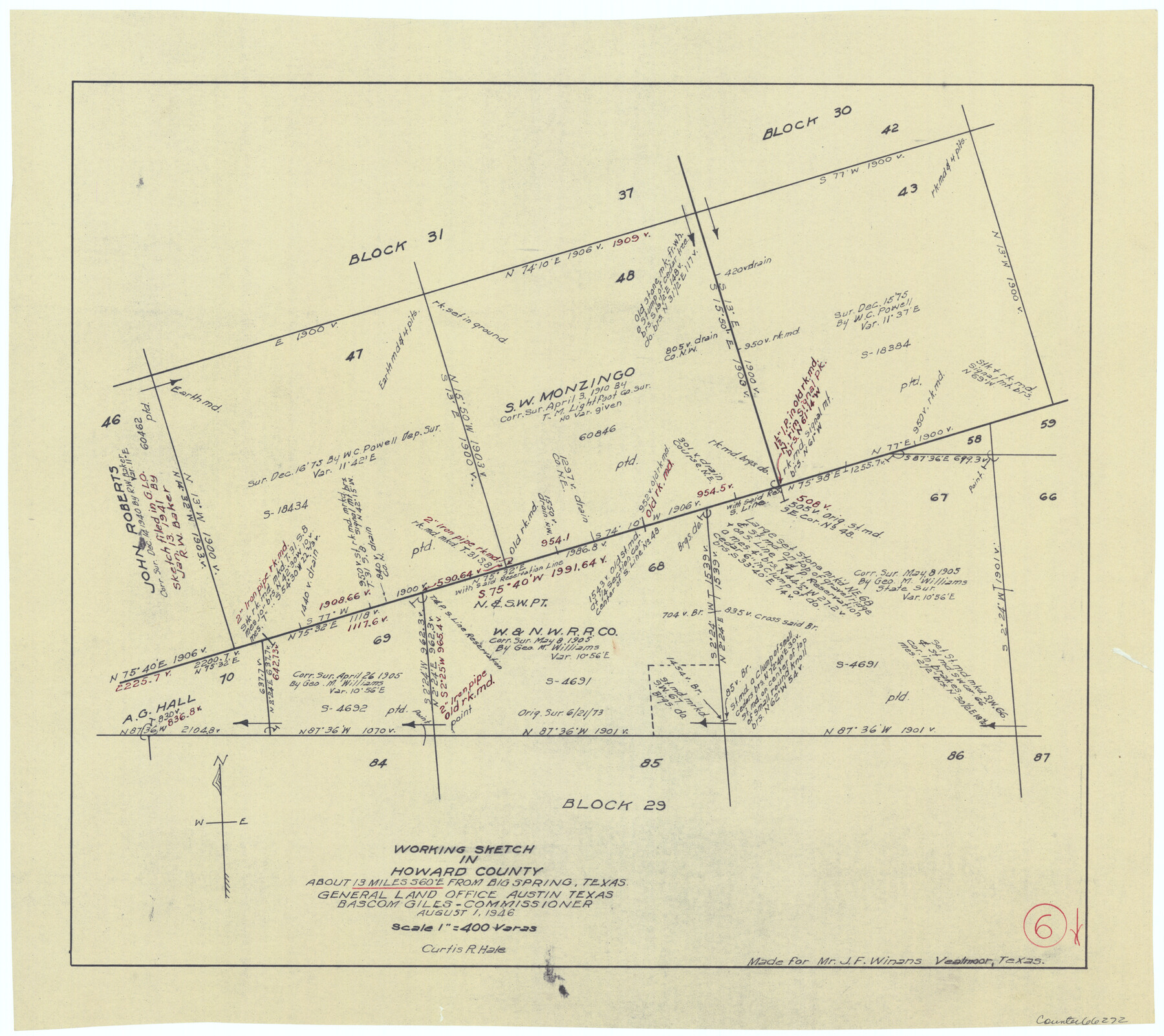
Howard County Working Sketch 6
-
Map/Doc
66272
-
Collection
General Map Collection
-
Object Dates
8/1/1946 (Creation Date)
-
People and Organizations
Curtis R. Hale (Draftsman)
-
Counties
Howard
-
Subjects
Surveying Working Sketch
-
Height x Width
17.3 x 19.5 inches
43.9 x 49.5 cm
-
Scale
1" = 400 varas
Part of: General Map Collection
Kleberg County Boundary File 2d

Print $20.00
- Digital $50.00
Kleberg County Boundary File 2d
Size 9.1 x 34.6 inches
Map/Doc 64980
Mason County Sketch File 17a

Print $6.00
- Digital $50.00
Mason County Sketch File 17a
1887
Size 10.3 x 10.9 inches
Map/Doc 30707
Matagorda Bay Oil Area, Matagorda, Calhoun & Jackson Cos.

Print $40.00
- Digital $50.00
Matagorda Bay Oil Area, Matagorda, Calhoun & Jackson Cos.
1927
Size 34.9 x 66.8 inches
Map/Doc 2934
Nueces County Aerial Photograph Index Sheet 5

Print $20.00
- Digital $50.00
Nueces County Aerial Photograph Index Sheet 5
1956
Size 19.5 x 23.4 inches
Map/Doc 83738
Sabine County

Print $20.00
- Digital $50.00
Sabine County
1920
Size 41.2 x 31.8 inches
Map/Doc 77413
Trinity River, Allison Sheet/Denton Creek

Print $4.00
- Digital $50.00
Trinity River, Allison Sheet/Denton Creek
1928
Size 26.3 x 24.2 inches
Map/Doc 65223
Montgomery County Rolled Sketch 42

Print $20.00
- Digital $50.00
Montgomery County Rolled Sketch 42
1939
Size 14.1 x 20.3 inches
Map/Doc 6815
Wheeler County Sketch File 8

Print $6.00
- Digital $50.00
Wheeler County Sketch File 8
1935
Size 11.4 x 8.8 inches
Map/Doc 40005
Jasper County Boundary File 1

Print $50.00
- Digital $50.00
Jasper County Boundary File 1
Size 12.6 x 20.5 inches
Map/Doc 55462
Travis County Sketch File 25

Print $4.00
- Digital $50.00
Travis County Sketch File 25
1876
Size 12.7 x 8.5 inches
Map/Doc 38334
El Paso County Sketch File 19

Print $30.00
- Digital $50.00
El Paso County Sketch File 19
1905
Size 13.3 x 8.7 inches
Map/Doc 22009
Parker County Sketch File 32

Print $6.00
- Digital $50.00
Parker County Sketch File 32
Size 11.0 x 12.2 inches
Map/Doc 33574
You may also like
Texas Coordinate File 3

Print $40.00
- Digital $50.00
Texas Coordinate File 3
Size 36.1 x 49.1 inches
Map/Doc 75306
Map of City of Lampasas, Texas

Print $20.00
- Digital $50.00
Map of City of Lampasas, Texas
1935
Size 26.1 x 17.6 inches
Map/Doc 4827
Cooke County Boundary File 1b

Print $28.00
- Digital $50.00
Cooke County Boundary File 1b
Size 12.6 x 7.4 inches
Map/Doc 51835
Colorado River, Lane City Sheet

Print $4.00
- Digital $50.00
Colorado River, Lane City Sheet
1941
Size 27.0 x 29.9 inches
Map/Doc 65316
Donley County Sketch File 16

Print $4.00
- Digital $50.00
Donley County Sketch File 16
Size 14.6 x 8.8 inches
Map/Doc 21253
Trinity River, Levee Improvements, District Widths of Floodways

Print $20.00
- Digital $50.00
Trinity River, Levee Improvements, District Widths of Floodways
1920
Size 25.0 x 18.6 inches
Map/Doc 65252
Nueces County Working Sketch 4

Print $20.00
- Digital $50.00
Nueces County Working Sketch 4
1951
Size 46.8 x 36.2 inches
Map/Doc 71306
Garza County Sketch File 7

Print $4.00
- Digital $50.00
Garza County Sketch File 7
1900
Size 13.3 x 8.5 inches
Map/Doc 24060
![90327, [Block B9], Twichell Survey Records](https://historictexasmaps.com/wmedia_w700/maps/90327-1.tif.jpg)
Grayson County Sketch File 7

Print $40.00
- Digital $50.00
Grayson County Sketch File 7
1856
Size 12.3 x 12.1 inches
Map/Doc 24470
Frio County Working Sketch 27

Print $20.00
- Digital $50.00
Frio County Working Sketch 27
Size 25.3 x 36.8 inches
Map/Doc 78193
Morris County Sketch File 5

Print $20.00
- Digital $50.00
Morris County Sketch File 5
Size 21.4 x 11.6 inches
Map/Doc 42132