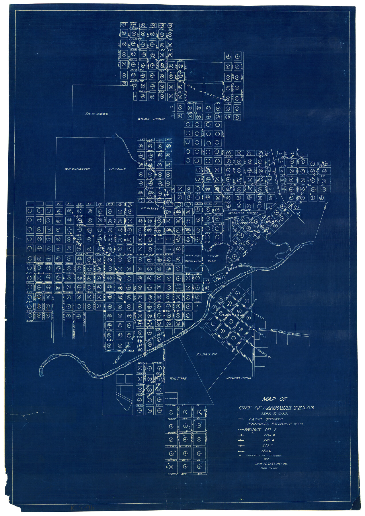
Map of City of Lampasas, Texas
K-7-9h, A-6-58
-
Map/Doc
4827
-
Collection
General Map Collection
-
Object Dates
9/5/1935 (Creation Date)
-
People and Organizations
Dan W. Taylor Jr. (Draftsman)
-
Counties
Lampasas
-
Subjects
City
-
Height x Width
26.1 x 17.6 inches
66.3 x 44.7 cm
-
Scale
1" = 800 feet
-
Features
Lampasas
GC&SF
Hanna Park
Hanna Springs
Burleson Creek
Cooper Park
Gibson Branch [of Burleson Creek]
Part of: General Map Collection
Robertson County Rolled Sketch 6

Print $20.00
- Digital $50.00
Robertson County Rolled Sketch 6
Size 22.8 x 15.6 inches
Map/Doc 7512
Kerr County Working Sketch 17

Print $20.00
- Digital $50.00
Kerr County Working Sketch 17
1956
Size 20.0 x 23.7 inches
Map/Doc 70048
Flight Mission No. DAG-22K, Frame 77, Matagorda County

Print $20.00
- Digital $50.00
Flight Mission No. DAG-22K, Frame 77, Matagorda County
1953
Size 18.6 x 22.4 inches
Map/Doc 86464
Reeves County Working Sketch 30

Print $20.00
- Digital $50.00
Reeves County Working Sketch 30
1969
Size 31.1 x 36.5 inches
Map/Doc 63473
Pecos County Working Sketch 102

Print $40.00
- Digital $50.00
Pecos County Working Sketch 102
1971
Size 36.9 x 52.7 inches
Map/Doc 71575
Township 14 South Range 15 West of the Louisiana Meridian, Louisiana

Print $20.00
- Digital $50.00
Township 14 South Range 15 West of the Louisiana Meridian, Louisiana
1875
Size 19.6 x 24.6 inches
Map/Doc 65859
Cameron County Rolled Sketch Z2

Print $20.00
- Digital $50.00
Cameron County Rolled Sketch Z2
1937
Size 23.7 x 40.9 inches
Map/Doc 5402
Travis County Sketch File 52

Print $8.00
- Digital $50.00
Travis County Sketch File 52
1942
Size 14.4 x 8.9 inches
Map/Doc 38391
Robertson County Rolled Sketch 1A

Print $20.00
- Digital $50.00
Robertson County Rolled Sketch 1A
1966
Size 45.3 x 28.1 inches
Map/Doc 9863
Hays County Rolled Sketch 33

Print $20.00
- Digital $50.00
Hays County Rolled Sketch 33
Size 15.4 x 19.1 inches
Map/Doc 89012
Jim Hogg County Working Sketch 1

Print $20.00
- Digital $50.00
Jim Hogg County Working Sketch 1
1933
Size 30.4 x 25.3 inches
Map/Doc 66587
Reagan County Working Sketch 39

Print $20.00
- Digital $50.00
Reagan County Working Sketch 39
1971
Size 22.5 x 36.1 inches
Map/Doc 71881
You may also like
Val Verde County Sketch File 52a

Print $20.00
- Digital $50.00
Val Verde County Sketch File 52a
1885
Size 21.5 x 22.1 inches
Map/Doc 12592
Johnson County Boundary File 51b

Print $80.00
- Digital $50.00
Johnson County Boundary File 51b
Size 53.9 x 9.4 inches
Map/Doc 55619
Karte von den Vermessungen im Grant und in der Gegend zwischen demselben und Neu Braunfels

Print $20.00
- Digital $50.00
Karte von den Vermessungen im Grant und in der Gegend zwischen demselben und Neu Braunfels
1850
Size 24.0 x 19.0 inches
Map/Doc 94446
Navarro County Working Sketch 14

Print $20.00
- Digital $50.00
Navarro County Working Sketch 14
1981
Size 36.8 x 33.1 inches
Map/Doc 71244
Brazoria County Rolled Sketch 36

Print $20.00
- Digital $50.00
Brazoria County Rolled Sketch 36
Size 18.5 x 25.0 inches
Map/Doc 5172
General Highway Map, Fort Bend County, Texas

Print $20.00
General Highway Map, Fort Bend County, Texas
1939
Size 18.6 x 25.2 inches
Map/Doc 79093
[S. M. Walker, D. P. Allen, J. C. Guinn, J. R. Lamar and surrounding surveys]
![90335, [S. M. Walker, D. P. Allen, J. C. Guinn, J. R. Lamar and surrounding surveys], Twichell Survey Records](https://historictexasmaps.com/wmedia_w700/maps/90335-1.tif.jpg)
Print $3.00
- Digital $50.00
[S. M. Walker, D. P. Allen, J. C. Guinn, J. R. Lamar and surrounding surveys]
1912
Size 9.8 x 11.3 inches
Map/Doc 90335
Runnels County Rolled Sketch 46

Print $20.00
- Digital $50.00
Runnels County Rolled Sketch 46
1954
Size 32.3 x 38.5 inches
Map/Doc 10622
Texas, Matagorda Bay, Matagorda Peninsula, Cany Creek to Tiger Island Channel

Print $40.00
- Digital $50.00
Texas, Matagorda Bay, Matagorda Peninsula, Cany Creek to Tiger Island Channel
1933
Size 31.4 x 48.6 inches
Map/Doc 69991
Palo Pinto County Working Sketch 25

Print $20.00
- Digital $50.00
Palo Pinto County Working Sketch 25
1991
Map/Doc 71408
Liberty County

Print $40.00
- Digital $50.00
Liberty County
1926
Size 49.6 x 52.5 inches
Map/Doc 16879
