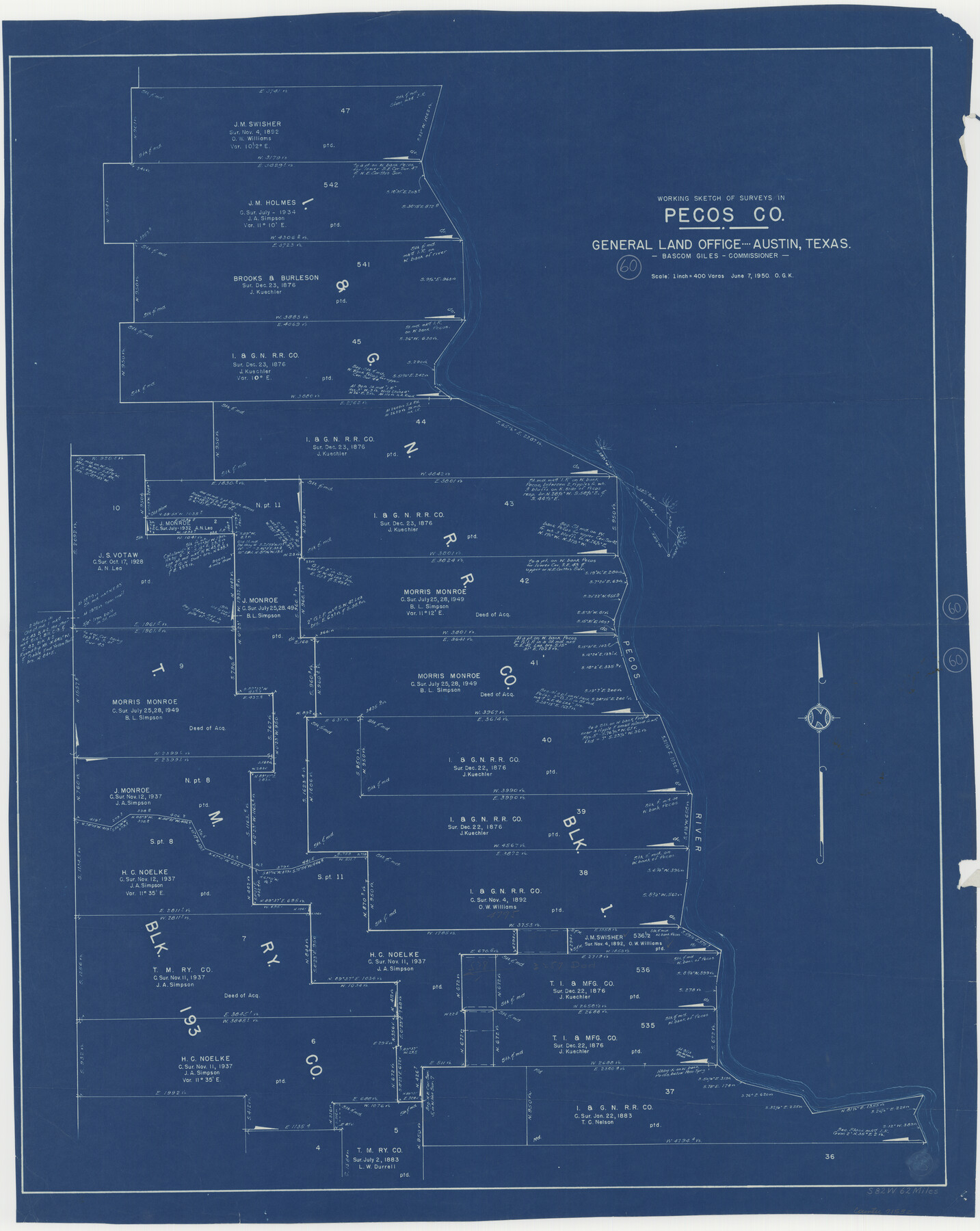
Pecos County Working Sketch 60
-
Map/Doc
71532
-
Collection
General Map Collection
-
Object Dates
6/7/1950 (Creation Date)
-
People and Organizations
Otto G. Kurio (Draftsman)
-
Counties
Pecos
-
Subjects
Surveying Working Sketch
-
Height x Width
37.0 x 29.5 inches
94.0 x 74.9 cm
-
Scale
1" = 400 varas
Part of: General Map Collection
[Right of Way & Track Map, The Texas & Pacific Ry. Co. Main Line]
![64661, [Right of Way & Track Map, The Texas & Pacific Ry. Co. Main Line], General Map Collection](https://historictexasmaps.com/wmedia_w700/maps/64661.tif.jpg)
Print $20.00
- Digital $50.00
[Right of Way & Track Map, The Texas & Pacific Ry. Co. Main Line]
Size 11.0 x 18.6 inches
Map/Doc 64661
Travis County Boundary File 1

Print $8.00
- Digital $50.00
Travis County Boundary File 1
Size 9.0 x 14.6 inches
Map/Doc 59403
Ward County Rolled Sketch 24E

Print $40.00
- Digital $50.00
Ward County Rolled Sketch 24E
1967
Size 42.3 x 64.9 inches
Map/Doc 10116
Map of Titus County

Print $20.00
- Digital $50.00
Map of Titus County
1857
Size 24.1 x 34.5 inches
Map/Doc 83380
Dickens County Sketch File 9

Print $4.00
- Digital $50.00
Dickens County Sketch File 9
Size 21.6 x 20.9 inches
Map/Doc 11319
Williamson County Rolled Sketch 8

Print $20.00
- Digital $50.00
Williamson County Rolled Sketch 8
Size 15.1 x 18.0 inches
Map/Doc 8265
Map of a Route from Austin-City to Paso del Norte & c.

Print $20.00
- Digital $50.00
Map of a Route from Austin-City to Paso del Norte & c.
1849
Size 11.7 x 30.5 inches
Map/Doc 2121
Gray County Sketch File 9

Print $38.00
- Digital $50.00
Gray County Sketch File 9
1889
Size 11.2 x 8.4 inches
Map/Doc 24426

Bailey County Sketch File 6

Print $40.00
- Digital $50.00
Bailey County Sketch File 6
Size 26.5 x 31.9 inches
Map/Doc 10884
Carte de la Louisiane et du Cours du Mississipi

Print $20.00
- Digital $50.00
Carte de la Louisiane et du Cours du Mississipi
1718
Size 21.7 x 28.6 inches
Map/Doc 95161
Montgomery County Working Sketch 12

Print $20.00
- Digital $50.00
Montgomery County Working Sketch 12
1933
Size 32.5 x 31.9 inches
Map/Doc 71119
You may also like
Wise County Sketch File 33

Print $22.00
- Digital $50.00
Wise County Sketch File 33
Size 13.7 x 18.1 inches
Map/Doc 40590
Maps of Gulf Intracoastal Waterway, Texas - Sabine River to the Rio Grande and connecting waterways including ship channels

Print $20.00
- Digital $50.00
Maps of Gulf Intracoastal Waterway, Texas - Sabine River to the Rio Grande and connecting waterways including ship channels
1966
Size 14.6 x 22.3 inches
Map/Doc 61930
McMullen County Working Sketch 40

Print $40.00
- Digital $50.00
McMullen County Working Sketch 40
1975
Size 48.3 x 34.8 inches
Map/Doc 70741
Wharton County Working Sketch 4

Print $20.00
- Digital $50.00
Wharton County Working Sketch 4
Size 16.3 x 21.3 inches
Map/Doc 72468
New Birmingham, Cherokee County, Texas

Print $20.00
- Digital $50.00
New Birmingham, Cherokee County, Texas
1891
Size 23.1 x 19.2 inches
Map/Doc 96617
[South part of Bailey County showing School Leagues]
![92992, [South part of Bailey County showing School Leagues], Twichell Survey Records](https://historictexasmaps.com/wmedia_w700/maps/92992-1.tif.jpg)
Print $2.00
- Digital $50.00
[South part of Bailey County showing School Leagues]
1913
Size 12.1 x 8.1 inches
Map/Doc 92992
Sutton County Sketch File Ca

Print $6.00
- Digital $50.00
Sutton County Sketch File Ca
1901
Size 12.3 x 9.8 inches
Map/Doc 37382
Red River County Sketch File 21

Print $4.00
- Digital $50.00
Red River County Sketch File 21
Size 12.7 x 7.9 inches
Map/Doc 35154
Flight Mission No. BQY-4M, Frame 39, Harris County

Print $20.00
- Digital $50.00
Flight Mission No. BQY-4M, Frame 39, Harris County
1953
Size 18.6 x 22.3 inches
Map/Doc 85254
Frio County Sketch File 2a

Print $6.00
- Digital $50.00
Frio County Sketch File 2a
1861
Size 16.0 x 11.0 inches
Map/Doc 23107
[Blocks C34, C44, C40, C42, C31-C38, A19 and others in vicinity]
![93210, [Blocks C34, C44, C40, C42, C31-C38, A19 and others in vicinity], Twichell Survey Records](https://historictexasmaps.com/wmedia_w700/maps/93210-1.tif.jpg)
Print $40.00
- Digital $50.00
[Blocks C34, C44, C40, C42, C31-C38, A19 and others in vicinity]
Size 71.0 x 55.2 inches
Map/Doc 93210
Flight Mission No. BQR-7K, Frame 33, Brazoria County

Print $20.00
- Digital $50.00
Flight Mission No. BQR-7K, Frame 33, Brazoria County
1952
Size 18.7 x 22.3 inches
Map/Doc 84031