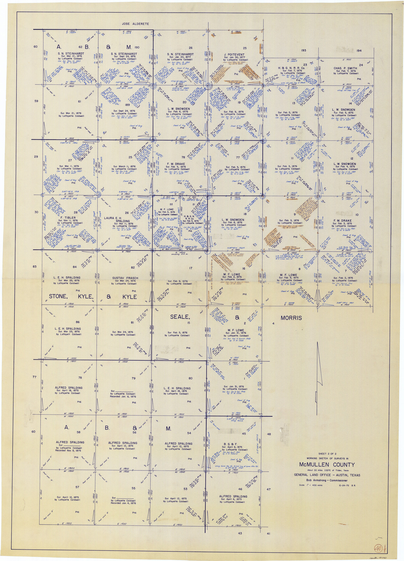
McMullen County Working Sketch 40
-
Map/Doc
70741
-
Collection
General Map Collection
-
Object Dates
10/24/1975 (Creation Date)
-
People and Organizations
Beverly Robison (Draftsman)
-
Counties
McMullen
-
Subjects
Surveying Working Sketch
-
Height x Width
48.3 x 34.8 inches
122.7 x 88.4 cm
-
Scale
1" = 400 varas
Part of: General Map Collection

Reeves County

Print $20.00
- Digital $50.00
Reeves County
1945
Size 46.4 x 37.3 inches
Map/Doc 77406
El Paso County Rolled Sketch 43A

Print $20.00
- Digital $50.00
El Paso County Rolled Sketch 43A
Size 23.2 x 22.6 inches
Map/Doc 5829
Atascosa County Working Sketch 12

Print $20.00
- Digital $50.00
Atascosa County Working Sketch 12
1926
Size 23.0 x 29.2 inches
Map/Doc 67208
Crockett County Sketch File 60

Print $22.00
- Digital $50.00
Crockett County Sketch File 60
1925
Size 11.4 x 8.7 inches
Map/Doc 19837
Comal County Working Sketch 14

Print $40.00
- Digital $50.00
Comal County Working Sketch 14
1992
Size 25.4 x 49.9 inches
Map/Doc 68180
Flight Mission No. CUG-1P, Frame 24, Kleberg County

Print $20.00
- Digital $50.00
Flight Mission No. CUG-1P, Frame 24, Kleberg County
1956
Size 18.5 x 22.1 inches
Map/Doc 86114
Angelina County Sketch File 32

Print $18.00
- Digital $50.00
Angelina County Sketch File 32
1994
Size 14.2 x 8.6 inches
Map/Doc 13092
Kent County Working Sketch 23

Print $20.00
- Digital $50.00
Kent County Working Sketch 23
1987
Size 47.2 x 43.0 inches
Map/Doc 70030
Parmer County Working Sketch Graphic Index

Print $20.00
- Digital $50.00
Parmer County Working Sketch Graphic Index
1926
Map/Doc 76662
Flight Mission No. DQN-2K, Frame 38, Calhoun County

Print $20.00
- Digital $50.00
Flight Mission No. DQN-2K, Frame 38, Calhoun County
1953
Size 15.5 x 15.4 inches
Map/Doc 84243
Travis County Boundary File 6

Print $109.00
- Digital $50.00
Travis County Boundary File 6
Size 14.6 x 9.1 inches
Map/Doc 59433
You may also like
Map of Young County

Print $20.00
- Digital $50.00
Map of Young County
1880
Size 22.0 x 20.3 inches
Map/Doc 4174
Dickens County Sketch File E

Print $8.00
- Digital $50.00
Dickens County Sketch File E
Size 11.3 x 8.7 inches
Map/Doc 20843
Sherman County

Print $20.00
- Digital $50.00
Sherman County
1932
Size 43.1 x 39.9 inches
Map/Doc 63036
San Jacinto County Working Sketch 16

Print $20.00
- Digital $50.00
San Jacinto County Working Sketch 16
1934
Size 35.7 x 42.2 inches
Map/Doc 63729
Terrell County Working Sketch 38

Print $40.00
- Digital $50.00
Terrell County Working Sketch 38
1950
Size 89.1 x 24.9 inches
Map/Doc 62131
Pecos County Sketch File 111

Print $18.00
- Digital $50.00
Pecos County Sketch File 111
Size 13.3 x 8.8 inches
Map/Doc 34052
Flight Mission No. BQR-9K, Frame 42, Brazoria County

Print $20.00
- Digital $50.00
Flight Mission No. BQR-9K, Frame 42, Brazoria County
1952
Size 18.6 x 22.2 inches
Map/Doc 84046
Sketch of Kent Co.

Print $20.00
- Digital $50.00
Sketch of Kent Co.
1884
Size 15.1 x 16.5 inches
Map/Doc 439
Map of the Fort Worth & Denver City Railway

Print $40.00
- Digital $50.00
Map of the Fort Worth & Denver City Railway
1887
Size 21.7 x 72.8 inches
Map/Doc 64479
The Kennedy and Pringle Colony. June 3, 1842

Print $20.00
The Kennedy and Pringle Colony. June 3, 1842
2020
Size 23.0 x 17.7 inches
Map/Doc 96368
[Map of Texas and Pacific Blocks from Brazos River westward through Palo Pinto, Stephens, Shackelford, Jones, Callahan, Taylor, Fisher, Nolan and Mitchell Counties]
![93460, [Map of Texas and Pacific Blocks from Brazos River westward through Palo Pinto, Stephens, Shackelford, Jones, Callahan, Taylor, Fisher, Nolan and Mitchell Counties], General Map Collection](https://historictexasmaps.com/wmedia_w700/maps/93460.tif.jpg)
Print $40.00
- Digital $50.00
[Map of Texas and Pacific Blocks from Brazos River westward through Palo Pinto, Stephens, Shackelford, Jones, Callahan, Taylor, Fisher, Nolan and Mitchell Counties]
Size 87.1 x 18.8 inches
Map/Doc 93460
Crockett County Rolled Sketch P1

Print $82.00
- Digital $50.00
Crockett County Rolled Sketch P1
1927
Size 10.3 x 15.9 inches
Map/Doc 44220