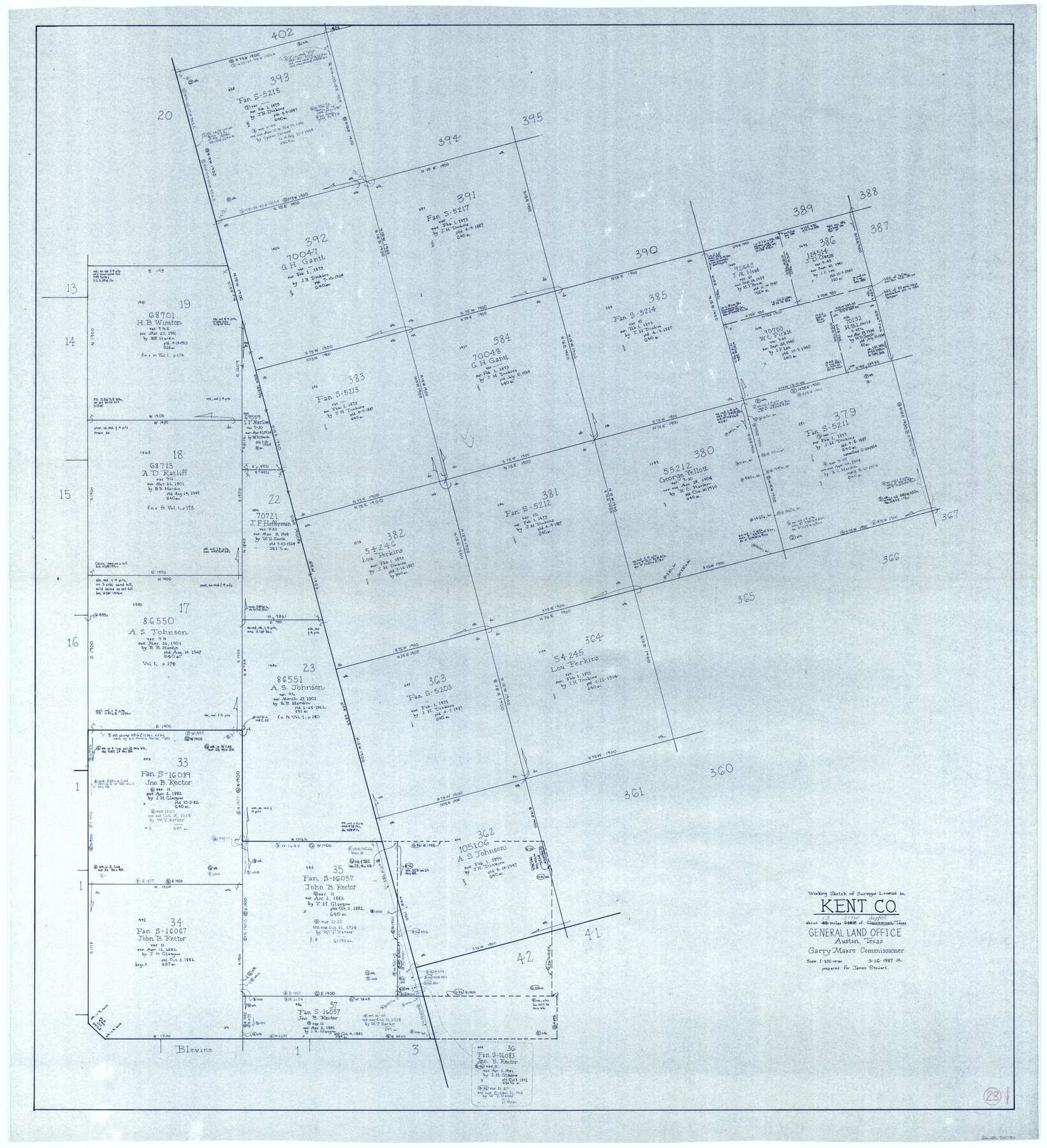
Kent County Working Sketch 23
-
Map/Doc
70030
-
Collection
General Map Collection
-
Object Dates
3/26/1987 (Creation Date)
-
People and Organizations
Joan Kilpatrick (Draftsman)
-
Counties
Kent
-
Subjects
Surveying Working Sketch
-
Height x Width
47.2 x 43.0 inches
119.9 x 109.2 cm
-
Scale
1" = 300 varas
Part of: General Map Collection
El Paso County Boundary File 24

Print $32.00
- Digital $50.00
El Paso County Boundary File 24
Size 14.8 x 9.6 inches
Map/Doc 53221

Runnels County Sketch File 3

Print $4.00
Runnels County Sketch File 3
1871
Size 13.0 x 8.1 inches
Map/Doc 35432
Hydograhic Survey H-994, Corpus Christi Pass

Print $40.00
- Digital $50.00
Hydograhic Survey H-994, Corpus Christi Pass
1869
Size 31.8 x 53.7 inches
Map/Doc 2701
Presidio County Working Sketch 129

Print $20.00
- Digital $50.00
Presidio County Working Sketch 129
1988
Size 24.0 x 24.7 inches
Map/Doc 71807
Jefferson County Rolled Sketch 61G

Print $20.00
- Digital $50.00
Jefferson County Rolled Sketch 61G
1928
Size 27.2 x 40.3 inches
Map/Doc 6416
Erath County Sketch File 26

Print $6.00
- Digital $50.00
Erath County Sketch File 26
1896
Size 9.5 x 8.1 inches
Map/Doc 22306
Current Miscellaneous File 30

Print $8.00
- Digital $50.00
Current Miscellaneous File 30
1953
Size 10.6 x 8.2 inches
Map/Doc 73925
Webb County Working Sketch Graphic Index - northwest part

Print $40.00
- Digital $50.00
Webb County Working Sketch Graphic Index - northwest part
1984
Size 42.1 x 51.6 inches
Map/Doc 76736
Flight Mission No. BRE-4P, Frame 167, Nueces County

Print $20.00
- Digital $50.00
Flight Mission No. BRE-4P, Frame 167, Nueces County
1956
Size 18.6 x 22.5 inches
Map/Doc 86830
La Salle County Rolled Sketch 24

Print $20.00
- Digital $50.00
La Salle County Rolled Sketch 24
1955
Size 36.7 x 39.4 inches
Map/Doc 10655
Taylor County Rolled Sketch 30B

Print $20.00
- Digital $50.00
Taylor County Rolled Sketch 30B
Size 17.5 x 11.6 inches
Map/Doc 76411
You may also like
[Beaumont, Sour Lake and Western Ry. Right of Way and Alignment - Frisco]
![64111, [Beaumont, Sour Lake and Western Ry. Right of Way and Alignment - Frisco], General Map Collection](https://historictexasmaps.com/wmedia_w700/maps/64111.tif.jpg)
Print $20.00
- Digital $50.00
[Beaumont, Sour Lake and Western Ry. Right of Way and Alignment - Frisco]
1910
Size 19.8 x 45.9 inches
Map/Doc 64111

Map of New Brunswick and Nova Scotia / Map of Newfoundland / Map of the West Indies, Guatimala and part of Mexico to illustrate Olney's school geography

Print $20.00
- Digital $50.00
Map of New Brunswick and Nova Scotia / Map of Newfoundland / Map of the West Indies, Guatimala and part of Mexico to illustrate Olney's school geography
1844
Size 9.5 x 12.1 inches
Map/Doc 93544
Bandera County Sketch File 22

Print $4.00
- Digital $50.00
Bandera County Sketch File 22
Size 12.6 x 7.9 inches
Map/Doc 14012
Val Verde County Rolled Sketch 53

Print $20.00
- Digital $50.00
Val Verde County Rolled Sketch 53
1937
Size 32.0 x 25.0 inches
Map/Doc 8122

Duval County Sketch File 40b

Print $20.00
- Digital $50.00
Duval County Sketch File 40b
Size 28.0 x 31.4 inches
Map/Doc 11396
Childress County Sketch File 15

Print $8.00
- Digital $50.00
Childress County Sketch File 15
Size 14.3 x 8.3 inches
Map/Doc 18278
Schleicher County Working Sketch 2

Print $20.00
- Digital $50.00
Schleicher County Working Sketch 2
1903
Size 14.7 x 19.4 inches
Map/Doc 63804
Mills County Rolled Sketch 2

Print $20.00
- Digital $50.00
Mills County Rolled Sketch 2
1974
Size 24.1 x 22.8 inches
Map/Doc 6780
Duval County Rolled Sketch HO and R

Print $40.00
- Digital $50.00
Duval County Rolled Sketch HO and R
1933
Size 65.8 x 43.1 inches
Map/Doc 8807
Flight Mission No. BRA-16M, Frame 126, Jefferson County

Print $20.00
- Digital $50.00
Flight Mission No. BRA-16M, Frame 126, Jefferson County
1953
Size 18.5 x 22.5 inches
Map/Doc 85736