Mills County Rolled Sketch 2
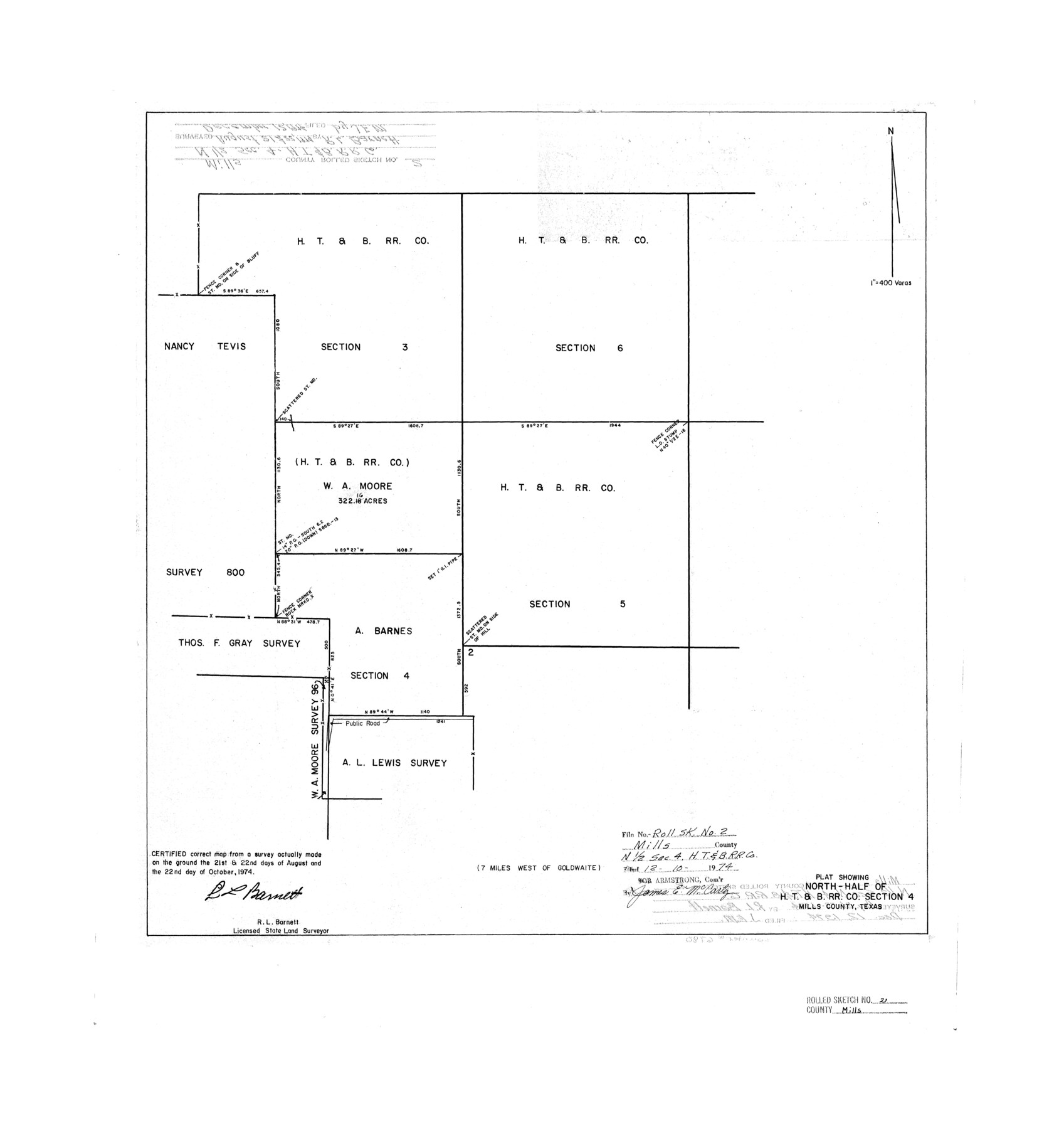
Plat showing north-half of H. T. & B. R.R. Co. section 4, Mills County, Texas
-
Map/Doc
6780
-
Collection
General Map Collection
-
Object Dates
1974/10/22 (Creation Date)
1974/12/10 (File Date)
-
People and Organizations
R.L. Barnett (Surveyor/Engineer)
-
Counties
Mills
-
Subjects
Surveying Rolled Sketch
-
Height x Width
24.1 x 22.8 inches
61.2 x 57.9 cm
-
Scale
1" = 400 varas
Part of: General Map Collection
Comal County Sketch File 6

Print $6.00
- Digital $50.00
Comal County Sketch File 6
Size 10.3 x 8.1 inches
Map/Doc 19008
Ector County Working Sketch 27

Print $20.00
- Digital $50.00
Ector County Working Sketch 27
Size 28.0 x 32.7 inches
Map/Doc 68870
Harris County Rolled Sketch 59

Print $20.00
- Digital $50.00
Harris County Rolled Sketch 59
1937
Size 18.7 x 20.9 inches
Map/Doc 6105
Upshur County Working Sketch 16, revised

Print $20.00
- Digital $50.00
Upshur County Working Sketch 16, revised
1997
Size 42.9 x 37.2 inches
Map/Doc 69574
Nacogdoches County Sketch File 14

Print $42.00
- Digital $50.00
Nacogdoches County Sketch File 14
1926
Size 8.8 x 11.3 inches
Map/Doc 32259
Harris County Sketch File F

Print $4.00
- Digital $50.00
Harris County Sketch File F
1860
Size 10.1 x 5.1 inches
Map/Doc 25317
Erath County Working Sketch 11

Print $20.00
- Digital $50.00
Erath County Working Sketch 11
1951
Size 45.1 x 36.2 inches
Map/Doc 69092
Current Miscellaneous File 27

Print $4.00
- Digital $50.00
Current Miscellaneous File 27
1952
Size 10.8 x 8.3 inches
Map/Doc 73909
Township 6 North Range 13 West, North Western District, Louisiana

Print $20.00
- Digital $50.00
Township 6 North Range 13 West, North Western District, Louisiana
1841
Size 19.7 x 24.8 inches
Map/Doc 65864
Gaines County Rolled Sketch 12

Print $20.00
- Digital $50.00
Gaines County Rolled Sketch 12
1940
Size 26.6 x 33.8 inches
Map/Doc 5932
McMullen County Sketch File 8

Print $4.00
- Digital $50.00
McMullen County Sketch File 8
1876
Size 8.6 x 8.8 inches
Map/Doc 31349
Walker County Working Sketch 10

Print $20.00
- Digital $50.00
Walker County Working Sketch 10
1935
Size 19.3 x 19.9 inches
Map/Doc 72290
You may also like
Harris County Working Sketch 120

Print $20.00
- Digital $50.00
Harris County Working Sketch 120
1985
Size 29.3 x 14.6 inches
Map/Doc 66012
Wichita County

Print $20.00
- Digital $50.00
Wichita County
1881
Size 18.5 x 19.8 inches
Map/Doc 4143
Flight Mission No. DQO-8K, Frame 10, Galveston County

Print $20.00
- Digital $50.00
Flight Mission No. DQO-8K, Frame 10, Galveston County
1952
Size 18.7 x 22.4 inches
Map/Doc 85133
[Sketch showing Block 42, Sections 221 and 222 and Block H, Sections 7 and 9]
![91714, [Sketch showing Block 42, Sections 221 and 222 and Block H, Sections 7 and 9], Twichell Survey Records](https://historictexasmaps.com/wmedia_w700/maps/91714-1.tif.jpg)
Print $2.00
- Digital $50.00
[Sketch showing Block 42, Sections 221 and 222 and Block H, Sections 7 and 9]
1919
Size 5.6 x 5.0 inches
Map/Doc 91714
Madison County

Print $20.00
- Digital $50.00
Madison County
1871
Size 14.0 x 19.6 inches
Map/Doc 3833
Harris County Working Sketch 1

Print $20.00
- Digital $50.00
Harris County Working Sketch 1
Size 15.8 x 15.8 inches
Map/Doc 65893
Rio Grande Rectification Project, El Paso and Juarez Valley

Print $20.00
- Digital $50.00
Rio Grande Rectification Project, El Paso and Juarez Valley
1935
Size 10.7 x 29.6 inches
Map/Doc 60866
Upshur County Working Sketch 17

Print $40.00
- Digital $50.00
Upshur County Working Sketch 17
1997
Size 48.4 x 37.1 inches
Map/Doc 69575
Garza County Rolled Sketch 13

Print $26.00
- Digital $50.00
Garza County Rolled Sketch 13
1935
Size 45.5 x 36.7 inches
Map/Doc 9047
Cass County Working Sketch 36

Print $20.00
- Digital $50.00
Cass County Working Sketch 36
1982
Size 37.9 x 39.4 inches
Map/Doc 67939
Greer County Sketch File 8

Print $20.00
- Digital $50.00
Greer County Sketch File 8
Size 16.7 x 23.6 inches
Map/Doc 11584
Sutton County Working Sketch 5

Print $20.00
- Digital $50.00
Sutton County Working Sketch 5
1969
Size 25.4 x 33.4 inches
Map/Doc 62348