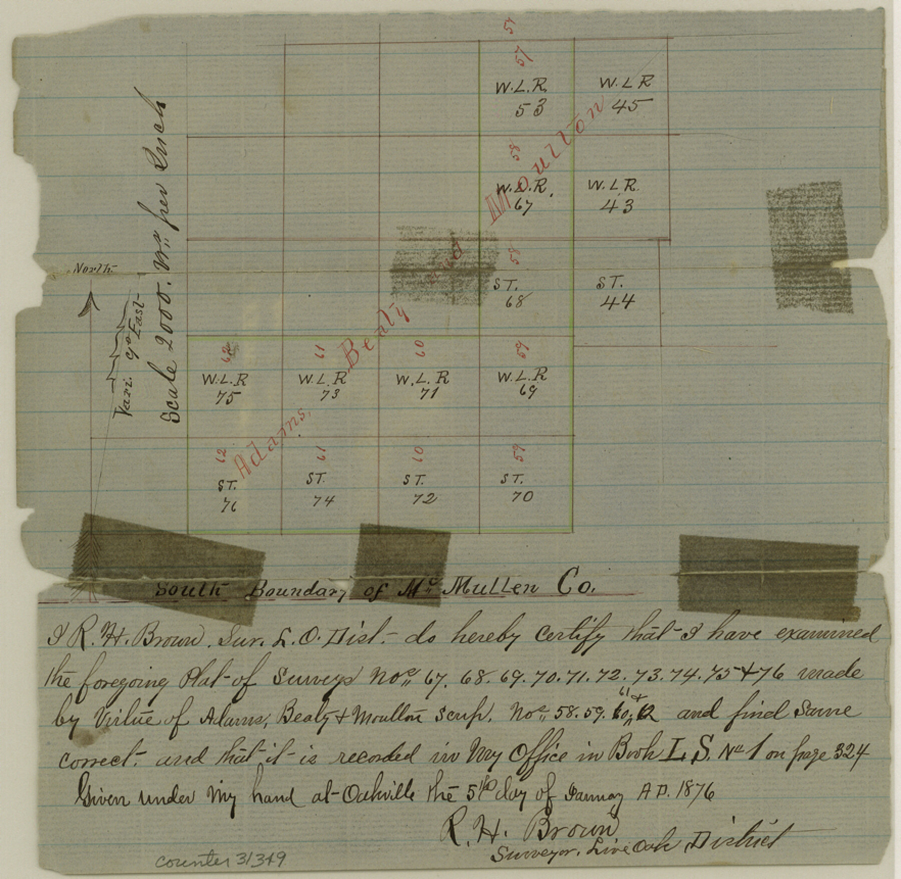
McMullen County Sketch File 8
[Sketch of A. B. & M. surveys]
-
Map/Doc
31349
-
Collection
General Map Collection
-
Object Dates
1876/1/5 (Creation Date)
1876/1/14 (File Date)
-
People and Organizations
R.H. Brown (Surveyor/Engineer)
-
Counties
McMullen Duval
-
Subjects
Surveying Sketch File
-
Height x Width
8.6 x 8.8 inches
21.8 x 22.4 cm
-
Medium
paper, manuscript
-
Scale
1" = 2000 varas
Part of: General Map Collection
Outer Continental Shelf Leasing Maps (Louisiana Offshore Operations)

Print $20.00
- Digital $50.00
Outer Continental Shelf Leasing Maps (Louisiana Offshore Operations)
1955
Size 15.9 x 10.8 inches
Map/Doc 76082
Zapata County Sketch File 13

Print $4.00
- Digital $50.00
Zapata County Sketch File 13
1930
Size 11.3 x 8.8 inches
Map/Doc 40952
Travis County Rolled Sketch 47

Print $40.00
- Digital $50.00
Travis County Rolled Sketch 47
1923
Size 57.3 x 26.5 inches
Map/Doc 10626
Current Miscellaneous File 17

Print $24.00
- Digital $50.00
Current Miscellaneous File 17
1951
Size 10.7 x 8.1 inches
Map/Doc 73838
Oldham County Sketch File 1

Print $24.00
- Digital $50.00
Oldham County Sketch File 1
1880
Size 12.6 x 7.9 inches
Map/Doc 33213
St. Louis, Brownsville & Mexico Railway Location map from Mile 40 to Mile 60

Print $40.00
- Digital $50.00
St. Louis, Brownsville & Mexico Railway Location map from Mile 40 to Mile 60
1905
Size 19.3 x 61.9 inches
Map/Doc 64080
Kent County Sketch File 10

Print $42.00
- Digital $50.00
Kent County Sketch File 10
1924
Size 22.1 x 35.5 inches
Map/Doc 11914
Wise County Sketch File 3

Print $4.00
- Digital $50.00
Wise County Sketch File 3
1856
Size 10.2 x 8.0 inches
Map/Doc 40528
Flight Mission No. BQY-4M, Frame 65, Harris County

Print $20.00
- Digital $50.00
Flight Mission No. BQY-4M, Frame 65, Harris County
1953
Size 18.7 x 22.4 inches
Map/Doc 85274
Flight Mission No. DCL-7C, Frame 68, Kenedy County

Print $20.00
- Digital $50.00
Flight Mission No. DCL-7C, Frame 68, Kenedy County
1943
Size 15.3 x 15.2 inches
Map/Doc 86054
Kendall County Sketch File 25

Print $6.00
- Digital $50.00
Kendall County Sketch File 25
1950
Size 11.2 x 8.6 inches
Map/Doc 28722
Colorado River, Willow Creek Valley Sheet[/Near Kirtley, Texas Mapped in Cooperation with Commissioner's Court of Fayette Co.]
![65322, Colorado River, Willow Creek Valley Sheet[/Near Kirtley, Texas Mapped in Cooperation with Commissioner's Court of Fayette Co.], General Map Collection](https://historictexasmaps.com/wmedia_w700/maps/65322.tif.jpg)
Print $20.00
- Digital $50.00
Colorado River, Willow Creek Valley Sheet[/Near Kirtley, Texas Mapped in Cooperation with Commissioner's Court of Fayette Co.]
1938
Size 38.2 x 40.8 inches
Map/Doc 65322
You may also like
Colorado County Working Sketch 19

Print $20.00
- Digital $50.00
Colorado County Working Sketch 19
1958
Size 25.3 x 19.1 inches
Map/Doc 68119
Brewster County Working Sketch 16

Print $20.00
- Digital $50.00
Brewster County Working Sketch 16
1930
Size 42.0 x 40.1 inches
Map/Doc 67550
Schleicher County Working Sketch 17

Print $20.00
- Digital $50.00
Schleicher County Working Sketch 17
1946
Size 21.8 x 23.1 inches
Map/Doc 63819
Chambers County Working Sketch 23

Print $20.00
- Digital $50.00
Chambers County Working Sketch 23
1979
Size 14.9 x 23.5 inches
Map/Doc 68006
Montgomery County Sketch File 37

Print $6.00
- Digital $50.00
Montgomery County Sketch File 37
Size 12.6 x 8.2 inches
Map/Doc 31916
Flight Mission No. DQN-2K, Frame 118, Calhoun County

Print $20.00
- Digital $50.00
Flight Mission No. DQN-2K, Frame 118, Calhoun County
1953
Size 18.5 x 22.2 inches
Map/Doc 84294

Calhoun County NRC Article 33.136 Sketch 10

Digital $50.00
Calhoun County NRC Article 33.136 Sketch 10
2023
Map/Doc 97254
Denton County Sketch File 10

Print $2.00
- Digital $50.00
Denton County Sketch File 10
1856
Size 8.5 x 13.5 inches
Map/Doc 20708
San Augustine County Boundary File 1

Print $17.00
- Digital $50.00
San Augustine County Boundary File 1
Size 9.3 x 12.2 inches
Map/Doc 58540
Map of Val Verde County

Print $40.00
- Digital $50.00
Map of Val Verde County
1898
Size 80.7 x 42.7 inches
Map/Doc 16913
[Blocks A, RG, O, B, S and 11]
![92858, [Blocks A, RG, O, B, S and 11], Twichell Survey Records](https://historictexasmaps.com/wmedia_w700/maps/92858-1.tif.jpg)
Print $20.00
- Digital $50.00
[Blocks A, RG, O, B, S and 11]
1921
Size 25.2 x 15.5 inches
Map/Doc 92858