Crockett County Rolled Sketch P1
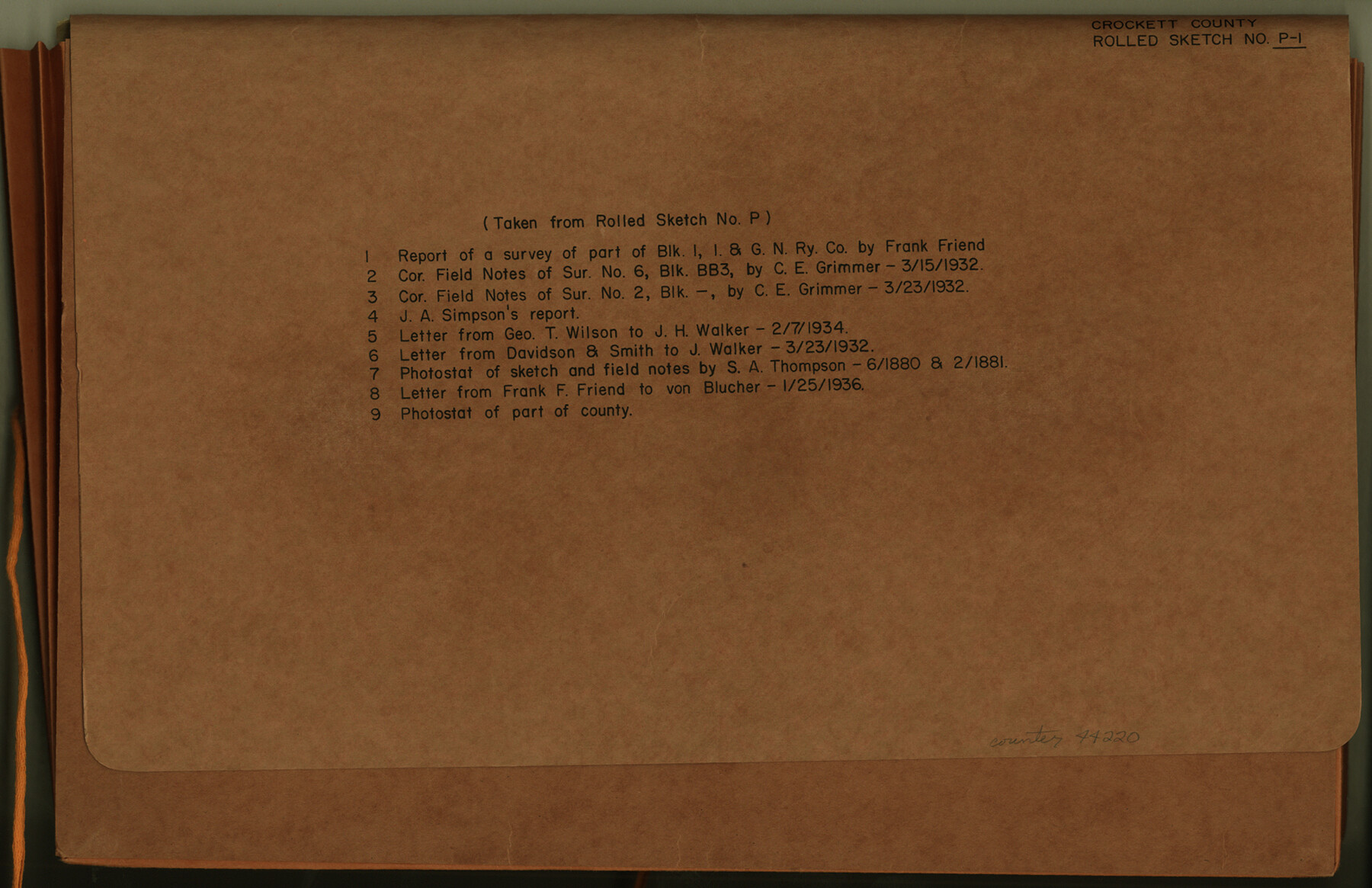
Report of a survey of a part of Block I, I. & G. N. Ry. Company, Crockett County, Texas [by Frank F. Friend and J.A. Simpson]
-
Map/Doc
44220
-
Collection
General Map Collection
-
Object Dates
1928/1/19 (File Date)
1927/9/22 (Creation Date)
-
People and Organizations
Frank F. Friend (Surveyor/Engineer)
J.A. Simpson (Surveyor/Engineer)
-
Counties
Crockett
-
Subjects
Surveying Rolled Sketch
-
Height x Width
10.3 x 15.9 inches
26.2 x 40.4 cm
-
Medium
multi-page, multi-format
-
Comments
See Crockett County Rolled Sketch P (8696) for sketch.
Related maps
Crockett County Rolled Sketch P

Print $20.00
- Digital $50.00
Crockett County Rolled Sketch P
1927
Size 24.3 x 47.3 inches
Map/Doc 8696
Part of: General Map Collection
Panola County Working Sketch 8

Print $20.00
- Digital $50.00
Panola County Working Sketch 8
1943
Map/Doc 71417
Motley County Sketch File 2 (N)

Print $22.00
- Digital $50.00
Motley County Sketch File 2 (N)
Size 8.3 x 14.8 inches
Map/Doc 31996
Guadalupe County Working Sketch 4

Print $20.00
- Digital $50.00
Guadalupe County Working Sketch 4
1939
Size 17.7 x 10.8 inches
Map/Doc 63313
A General Map of the Roman Empire Shewing the Situation of all its Provinces & ye Seats of ye Barbarous Nations on their Frontiers

Print $20.00
- Digital $50.00
A General Map of the Roman Empire Shewing the Situation of all its Provinces & ye Seats of ye Barbarous Nations on their Frontiers
1744
Size 10.8 x 20.5 inches
Map/Doc 96644
Angelina River, Mud Creek, Sheet 4

Print $4.00
- Digital $50.00
Angelina River, Mud Creek, Sheet 4
1937
Size 25.4 x 18.5 inches
Map/Doc 65078
Hutchinson County Rolled Sketch 40

Print $20.00
- Digital $50.00
Hutchinson County Rolled Sketch 40
1981
Size 26.5 x 37.5 inches
Map/Doc 6306
Map of Comal County

Print $20.00
- Digital $50.00
Map of Comal County
1862
Size 18.6 x 22.0 inches
Map/Doc 3429
Brazoria County Rolled Sketch 49

Print $20.00
- Digital $50.00
Brazoria County Rolled Sketch 49
1948
Size 24.1 x 36.5 inches
Map/Doc 5186
[Map of Line Dividing Fannin and Nacogdoches Districts]
![3134, [Map of Line Dividing Fannin and Nacogdoches Districts], General Map Collection](https://historictexasmaps.com/wmedia_w700/maps/3134.tif.jpg)
Print $20.00
- Digital $50.00
[Map of Line Dividing Fannin and Nacogdoches Districts]
1850
Size 35.6 x 40.8 inches
Map/Doc 3134
Glasscock County Boundary File 2

Print $14.00
- Digital $50.00
Glasscock County Boundary File 2
Size 14.4 x 9.1 inches
Map/Doc 53790
Flight Mission No. BRA-8M, Frame 125, Jefferson County

Print $20.00
- Digital $50.00
Flight Mission No. BRA-8M, Frame 125, Jefferson County
1953
Size 15.9 x 15.7 inches
Map/Doc 85621
Harris County Working Sketch 121

Print $20.00
- Digital $50.00
Harris County Working Sketch 121
1985
Size 34.4 x 18.6 inches
Map/Doc 66013
You may also like
Flight Mission No. DCL-7C, Frame 3, Kenedy County

Print $20.00
- Digital $50.00
Flight Mission No. DCL-7C, Frame 3, Kenedy County
1943
Size 18.5 x 22.3 inches
Map/Doc 85995
Spanish land grants (other than porciones) in the trans-Nueces

Spanish land grants (other than porciones) in the trans-Nueces
2009
Size 11.0 x 8.5 inches
Map/Doc 94046
Outer Continental Shelf Leasing Maps (Louisiana Offshore Operations)

Print $20.00
- Digital $50.00
Outer Continental Shelf Leasing Maps (Louisiana Offshore Operations)
1954
Size 15.8 x 10.0 inches
Map/Doc 76109
Presidio County Rolled Sketch 80B

Print $20.00
- Digital $50.00
Presidio County Rolled Sketch 80B
1943
Size 17.4 x 18.3 inches
Map/Doc 2060
The Republic County of Fayette. January 29, 1842

Print $20.00
The Republic County of Fayette. January 29, 1842
2020
Size 14.7 x 21.7 inches
Map/Doc 96134
Sketch Showing Original Corners and Connections affecting Blocks T1, T2, and T3 in Lamb and Castro Counties, Texas

Print $20.00
- Digital $50.00
Sketch Showing Original Corners and Connections affecting Blocks T1, T2, and T3 in Lamb and Castro Counties, Texas
Size 17.3 x 29.1 inches
Map/Doc 92982
[Block C39, Sections 22, 23 Millican Estate, 24]
![92345, [Block C39, Sections 22, 23 Millican Estate, 24], Twichell Survey Records](https://historictexasmaps.com/wmedia_w700/maps/92345-1.tif.jpg)
Print $20.00
- Digital $50.00
[Block C39, Sections 22, 23 Millican Estate, 24]
1956
Size 11.4 x 31.2 inches
Map/Doc 92345
Swisher County Working Sketch 1

Print $20.00
- Digital $50.00
Swisher County Working Sketch 1
1907
Size 19.4 x 16.3 inches
Map/Doc 62412
Sutton County Working Sketch Graphic Index, Sheet 2 (Sketches 25 to Most Recent)

Print $40.00
- Digital $50.00
Sutton County Working Sketch Graphic Index, Sheet 2 (Sketches 25 to Most Recent)
1941
Size 41.2 x 55.2 inches
Map/Doc 76706
General Highway Map, Randall County, Texas

Print $20.00
General Highway Map, Randall County, Texas
1940
Size 18.3 x 25.0 inches
Map/Doc 79224
Map of Crockett Co.

Print $20.00
- Digital $50.00
Map of Crockett Co.
1901
Size 31.7 x 42.4 inches
Map/Doc 1475
McCulloch County Sketch File 3

Print $12.00
- Digital $50.00
McCulloch County Sketch File 3
1893
Size 11.1 x 8.5 inches
Map/Doc 31169