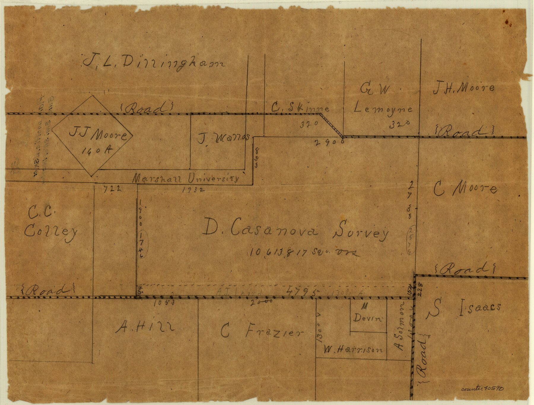
Wise County Sketch File 33
[Sketch of surveys around the Casanova survey west of Decatur]
-
Map/Doc
40590
-
Collection
General Map Collection
-
Counties
Wise
-
Subjects
Surveying Sketch File
-
Height x Width
13.7 x 18.1 inches
34.8 x 46.0 cm
-
Medium
paper, manuscript
Part of: General Map Collection
Randall County Boundary File 1

Print $26.00
- Digital $50.00
Randall County Boundary File 1
Size 14.0 x 8.5 inches
Map/Doc 58098
Pecos County Rolled Sketch 44A

Print $20.00
- Digital $50.00
Pecos County Rolled Sketch 44A
1912
Size 19.7 x 34.6 inches
Map/Doc 7223
Flight Mission No. CUG-2P, Frame 85, Kleberg County

Print $20.00
- Digital $50.00
Flight Mission No. CUG-2P, Frame 85, Kleberg County
1956
Size 18.5 x 22.2 inches
Map/Doc 86217
Polk County Sketch File 39

Print $24.00
- Digital $50.00
Polk County Sketch File 39
Size 8.3 x 13.3 inches
Map/Doc 34278
Kerr County Boundary File 4

Print $4.00
- Digital $50.00
Kerr County Boundary File 4
Size 11.1 x 8.3 inches
Map/Doc 64799

Burnet County Rolled Sketch 9

Print $40.00
- Digital $50.00
Burnet County Rolled Sketch 9
1971
Size 37.7 x 51.3 inches
Map/Doc 8545
Liberty County Rolled Sketch 15

Print $20.00
- Digital $50.00
Liberty County Rolled Sketch 15
2015
Size 36.2 x 24.5 inches
Map/Doc 94024
Wise County Working Sketch 10

Print $20.00
- Digital $50.00
Wise County Working Sketch 10
Size 17.4 x 18.4 inches
Map/Doc 72624
Garza County Sketch File G-1

Print $20.00
- Digital $50.00
Garza County Sketch File G-1
1904
Size 20.4 x 20.6 inches
Map/Doc 11554
Flight Mission No. CRC-3R, Frame 22, Chambers County

Print $20.00
- Digital $50.00
Flight Mission No. CRC-3R, Frame 22, Chambers County
1956
Size 18.6 x 22.3 inches
Map/Doc 84796
Sabine County Working Sketch 3

Print $3.00
- Digital $50.00
Sabine County Working Sketch 3
1911
Size 10.8 x 15.7 inches
Map/Doc 63674
You may also like
Nueces River, Clarkwood Sheet

Print $6.00
- Digital $50.00
Nueces River, Clarkwood Sheet
1942
Size 26.9 x 36.5 inches
Map/Doc 65099
Chart showing the positions of the lights in the Eighth L. H. District extending from the Perdido River, Florida to the Rio Grande, Texas

Print $20.00
- Digital $50.00
Chart showing the positions of the lights in the Eighth L. H. District extending from the Perdido River, Florida to the Rio Grande, Texas
1876
Size 24.7 x 18.2 inches
Map/Doc 72682
Terrell County Sketch File 25A

Print $20.00
- Digital $50.00
Terrell County Sketch File 25A
1890
Size 16.9 x 21.5 inches
Map/Doc 12424
Wheeler County

Print $20.00
- Digital $50.00
Wheeler County
1932
Size 41.7 x 38.0 inches
Map/Doc 73322
Flight Mission No. DAG-24K, Frame 38, Matagorda County

Print $20.00
- Digital $50.00
Flight Mission No. DAG-24K, Frame 38, Matagorda County
1953
Size 18.5 x 15.8 inches
Map/Doc 86525
[Block 1, Section 31]
![92171, [Block 1, Section 31], Twichell Survey Records](https://historictexasmaps.com/wmedia_w700/maps/92171-1.tif.jpg)
Print $20.00
- Digital $50.00
[Block 1, Section 31]
1946
Size 24.3 x 19.7 inches
Map/Doc 92171
Harris County Sketch File 70

Print $12.00
- Digital $50.00
Harris County Sketch File 70
1938
Size 11.3 x 8.8 inches
Map/Doc 25518
Sabine River, Dixon Sheet/Cowleach Fork of the Sabine River

Print $20.00
- Digital $50.00
Sabine River, Dixon Sheet/Cowleach Fork of the Sabine River
1935
Size 44.0 x 18.5 inches
Map/Doc 65145
Jones County Working Sketch 7

Print $20.00
- Digital $50.00
Jones County Working Sketch 7
1957
Size 30.8 x 12.7 inches
Map/Doc 66645
Culberson County Working Sketch 59

Print $20.00
- Digital $50.00
Culberson County Working Sketch 59
1974
Size 46.4 x 37.7 inches
Map/Doc 68513
Bandera County Working Sketch 2

Print $20.00
- Digital $50.00
Bandera County Working Sketch 2
Size 23.1 x 24.6 inches
Map/Doc 67595
Map of the River Sabine from Logan's Ferry to 32nd degree of north latitude

Print $3.00
- Digital $50.00
Map of the River Sabine from Logan's Ferry to 32nd degree of north latitude
1842
Size 8.7 x 11.6 inches
Map/Doc 93768