Burnet County Rolled Sketch 9
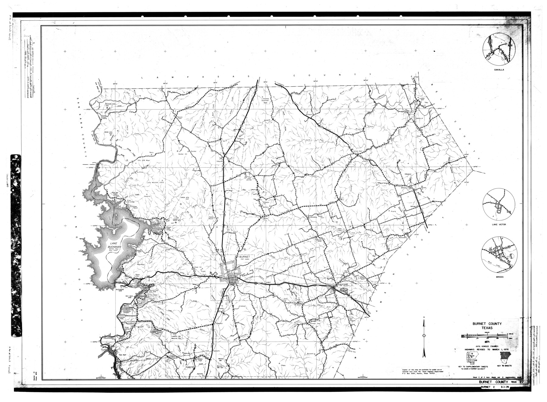
Burnet County, Texas [General Highway Map]
-
Map/Doc
8545
-
Collection
General Map Collection
-
Object Dates
1971 (Creation Date)
5/23/1980 (File Date)
3/1/1974 (Revision Date)
-
People and Organizations
Texas State Highway Department (Publisher)
-
Counties
Burnet
-
Subjects
County Surveying Rolled Sketch
-
Height x Width
37.7 x 51.3 inches
95.8 x 130.3 cm
-
Medium
mylar, print
Part of: General Map Collection
Bailey County Sketch File 20

Print $40.00
- Digital $50.00
Bailey County Sketch File 20
1948
Size 20.3 x 26.3 inches
Map/Doc 10890
Flight Mission No. DQN-2K, Frame 80, Calhoun County

Print $20.00
- Digital $50.00
Flight Mission No. DQN-2K, Frame 80, Calhoun County
1953
Size 18.4 x 22.2 inches
Map/Doc 84272
Duval County Sketch File 80

Print $32.00
- Digital $50.00
Duval County Sketch File 80
Size 14.1 x 8.9 inches
Map/Doc 21492
Harris County Working Sketch 124

Print $20.00
- Digital $50.00
Harris County Working Sketch 124
1993
Size 30.0 x 34.0 inches
Map/Doc 66016
[Sketch for Mineral Application 26501 - Sabine River, T. A. Oldhausen]
![2832, [Sketch for Mineral Application 26501 - Sabine River, T. A. Oldhausen], General Map Collection](https://historictexasmaps.com/wmedia_w700/maps/2832.tif.jpg)
Print $20.00
- Digital $50.00
[Sketch for Mineral Application 26501 - Sabine River, T. A. Oldhausen]
1931
Size 24.0 x 36.0 inches
Map/Doc 2832
[FT. W. & R. G. Ry. Right of Way Map, Winchell to Brady, McCulloch County, Texas]
![61414, [FT. W. & R. G. Ry. Right of Way Map, Winchell to Brady, McCulloch County, Texas], General Map Collection](https://historictexasmaps.com/wmedia_w700/maps/61414.tif.jpg)
Print $40.00
- Digital $50.00
[FT. W. & R. G. Ry. Right of Way Map, Winchell to Brady, McCulloch County, Texas]
1918
Size 38.2 x 122.0 inches
Map/Doc 61414
[Sketch for Mineral Application 16696-16697, Pecos River]
![65614, [Sketch for Mineral Application 16696-16697, Pecos River], General Map Collection](https://historictexasmaps.com/wmedia_w700/maps/65614.tif.jpg)
Print $40.00
- Digital $50.00
[Sketch for Mineral Application 16696-16697, Pecos River]
Size 42.6 x 69.4 inches
Map/Doc 65614
Lipscomb County Sketch File 6

Print $20.00
- Digital $50.00
Lipscomb County Sketch File 6
1965
Size 19.4 x 26.1 inches
Map/Doc 12005
Sherman County Rolled Sketch 4

Print $20.00
- Digital $50.00
Sherman County Rolled Sketch 4
Size 23.1 x 31.7 inches
Map/Doc 7786
McLennan County Sketch File 12

Print $4.00
- Digital $50.00
McLennan County Sketch File 12
Size 8.3 x 9.3 inches
Map/Doc 31265
Matagorda County Sketch File 33

Print $6.00
- Digital $50.00
Matagorda County Sketch File 33
1938
Size 14.2 x 8.8 inches
Map/Doc 30817
Lipscomb County

Print $20.00
- Digital $50.00
Lipscomb County
1889
Size 23.5 x 18.5 inches
Map/Doc 3817
You may also like
Pecos County Rolled Sketch 25 1/2

Print $20.00
- Digital $50.00
Pecos County Rolled Sketch 25 1/2
1888
Size 41.9 x 39.2 inches
Map/Doc 9688
Stonewall County Boundary File 4a

Print $18.00
- Digital $50.00
Stonewall County Boundary File 4a
Size 14.2 x 8.8 inches
Map/Doc 58984
Bexar County Sketch File 21

Print $4.00
- Digital $50.00
Bexar County Sketch File 21
1859
Size 12.2 x 7.9 inches
Map/Doc 14484
[Plat showing Blocks Z, Q and D]
![90289, [Plat showing Blocks Z, Q and D], Twichell Survey Records](https://historictexasmaps.com/wmedia_w700/maps/90289-1.tif.jpg)
Print $20.00
- Digital $50.00
[Plat showing Blocks Z, Q and D]
Size 15.9 x 21.2 inches
Map/Doc 90289
General Highway Map, Kerr County, Texas

Print $20.00
General Highway Map, Kerr County, Texas
1961
Size 24.8 x 18.2 inches
Map/Doc 79551
Rains County Boundary File 2

Print $4.00
- Digital $50.00
Rains County Boundary File 2
Size 8.2 x 5.8 inches
Map/Doc 58092
City of Mexia, Texas

Print $40.00
- Digital $50.00
City of Mexia, Texas
1961
Size 71.2 x 43.3 inches
Map/Doc 93671
Mills County Boundary File 1

Print $28.00
- Digital $50.00
Mills County Boundary File 1
Size 8.3 x 8.0 inches
Map/Doc 57259
General Highway Map, Crosby County, Texas

Print $20.00
General Highway Map, Crosby County, Texas
1961
Size 18.1 x 24.5 inches
Map/Doc 79426
[Plan for Fort Waul near Gonzales, Texas]
![88600, [Plan for Fort Waul near Gonzales, Texas], National Archives Digital Map Collection](https://historictexasmaps.com/wmedia_w700/maps/88600.tif.jpg)
Print $20.00
[Plan for Fort Waul near Gonzales, Texas]
1863
Size 12.3 x 20.3 inches
Map/Doc 88600
Edward K. Warren Subdivision No. 1 Block-W Situated in Bailey, Lamb, Parmer, and Castro Counties, Texas

Print $20.00
- Digital $50.00
Edward K. Warren Subdivision No. 1 Block-W Situated in Bailey, Lamb, Parmer, and Castro Counties, Texas
1913
Size 17.6 x 14.5 inches
Map/Doc 92163
Colorado County Sketch File 7

Print $4.00
- Digital $50.00
Colorado County Sketch File 7
1862
Size 13.1 x 8.0 inches
Map/Doc 18925