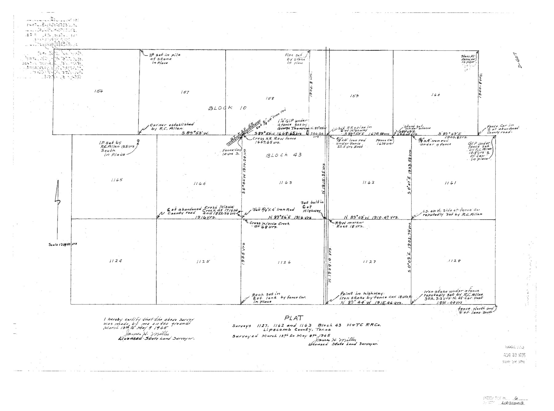
Lipscomb County Sketch File 6
Part of Block 43, H&TCRRCo and Block 10, Lipscomb County, Texas
-
Map/Doc
12005
-
Collection
General Map Collection
-
Object Dates
5/8/1965 (Creation Date)
8/23/1965 (File Date)
3/13/1965 (Survey Date)
5/8/1965 (Survey Date)
-
People and Organizations
James H. Miller (Surveyor/Engineer)
-
Counties
Lipscomb
-
Subjects
Surveying Sketch File
-
Height x Width
19.4 x 26.1 inches
49.3 x 66.3 cm
-
Medium
paper, print
-
Features
NT&SF
Part of: General Map Collection
Travis County Appraisal District Plat Map 1_0100

Print $20.00
- Digital $50.00
Travis County Appraisal District Plat Map 1_0100
Size 21.6 x 26.4 inches
Map/Doc 94205
Johnson County Working Sketch 1

Print $20.00
- Digital $50.00
Johnson County Working Sketch 1
Size 16.3 x 21.3 inches
Map/Doc 66614
Map of Erath County

Print $20.00
- Digital $50.00
Map of Erath County
1872
Size 21.0 x 19.4 inches
Map/Doc 4537
Kendall County Rolled Sketch 9

Print $20.00
- Digital $50.00
Kendall County Rolled Sketch 9
1990
Size 32.8 x 24.3 inches
Map/Doc 95298
Menard County Sketch File 11

Print $8.00
- Digital $50.00
Menard County Sketch File 11
1892
Size 12.8 x 8.3 inches
Map/Doc 31496
Sutton County Working Sketch 23

Print $20.00
- Digital $50.00
Sutton County Working Sketch 23
1981
Size 17.3 x 27.1 inches
Map/Doc 62366
Wilbarger County Working Sketch Graphic Index

Print $20.00
- Digital $50.00
Wilbarger County Working Sketch Graphic Index
1949
Size 46.7 x 38.0 inches
Map/Doc 76740
Flight Mission No. CRC-3R, Frame 100, Chambers County

Print $20.00
- Digital $50.00
Flight Mission No. CRC-3R, Frame 100, Chambers County
1956
Size 18.6 x 22.3 inches
Map/Doc 84838
Duval County Sketch File 52

Print $20.00
- Digital $50.00
Duval County Sketch File 52
1936
Size 21.0 x 28.6 inches
Map/Doc 11402
Andrews County Working Sketch 19

Print $20.00
- Digital $50.00
Andrews County Working Sketch 19
1964
Size 24.9 x 23.5 inches
Map/Doc 67065
[Surveys between Upper Keechi Creek and the Trinity River]
![293, [Surveys between Upper Keechi Creek and the Trinity River], General Map Collection](https://historictexasmaps.com/wmedia_w700/maps/293.tif.jpg)
Print $2.00
- Digital $50.00
[Surveys between Upper Keechi Creek and the Trinity River]
Size 8.5 x 6.9 inches
Map/Doc 293
Uvalde County Working Sketch 5

Print $20.00
- Digital $50.00
Uvalde County Working Sketch 5
1927
Size 13.4 x 18.0 inches
Map/Doc 72075
You may also like
Drum, Oyster and Bastrop Bays and Vicinity; Brazoria County, showing Subdivision for Mineral Development

Print $20.00
- Digital $50.00
Drum, Oyster and Bastrop Bays and Vicinity; Brazoria County, showing Subdivision for Mineral Development
1949
Size 35.4 x 45.4 inches
Map/Doc 1908
Liberty County Sketch File 6a

Print $2.00
- Digital $50.00
Liberty County Sketch File 6a
1859
Size 7.5 x 8.4 inches
Map/Doc 29896
[Bastrop District]
![83005, [Bastrop District], General Map Collection](https://historictexasmaps.com/wmedia_w700/maps/83005.tif.jpg)
Print $40.00
- Digital $50.00
[Bastrop District]
1895
Size 37.4 x 51.9 inches
Map/Doc 83005
Flight Mission No. DQN-1K, Frame 114, Calhoun County

Print $20.00
- Digital $50.00
Flight Mission No. DQN-1K, Frame 114, Calhoun County
1953
Size 18.5 x 22.3 inches
Map/Doc 84180
Crosby County Sketch File 11a

Print $10.00
- Digital $50.00
Crosby County Sketch File 11a
1894
Size 8.7 x 4.4 inches
Map/Doc 20029
Zavala County Working Sketch 26

Print $20.00
- Digital $50.00
Zavala County Working Sketch 26
1990
Size 22.4 x 27.9 inches
Map/Doc 62101
Lampasas County Working Sketch 14

Print $20.00
- Digital $50.00
Lampasas County Working Sketch 14
1974
Size 23.4 x 21.8 inches
Map/Doc 70291
[Surveys along the Lavaca River]
![25, [Surveys along the Lavaca River], General Map Collection](https://historictexasmaps.com/wmedia_w700/maps/25.tif.jpg)
Print $2.00
- Digital $50.00
[Surveys along the Lavaca River]
1833
Size 12.9 x 8.9 inches
Map/Doc 25
Travis County Working Sketch 54

Print $20.00
- Digital $50.00
Travis County Working Sketch 54
1976
Size 30.1 x 32.0 inches
Map/Doc 69438
Webb County Sketch File B1

Print $20.00
- Digital $50.00
Webb County Sketch File B1
Size 16.9 x 26.4 inches
Map/Doc 12606
Briscoe County Sketch File 13

Print $168.00
- Digital $50.00
Briscoe County Sketch File 13
1982
Size 11.2 x 8.7 inches
Map/Doc 16428
Wood County Working Sketch 16

Print $20.00
- Digital $50.00
Wood County Working Sketch 16
1987
Size 21.7 x 17.7 inches
Map/Doc 62016