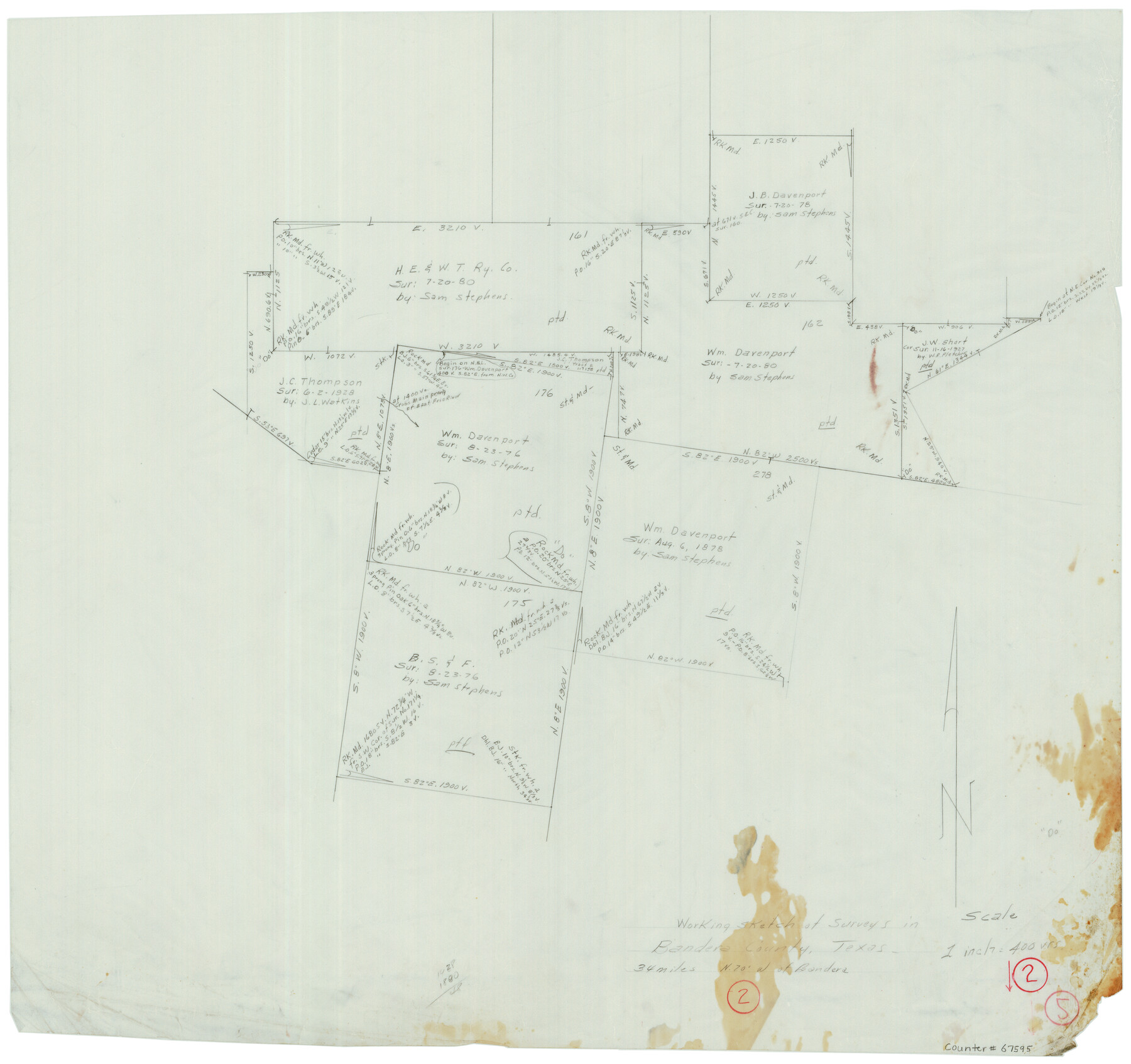
Bandera County Working Sketch 2
-
Map/Doc
67595
-
Collection
General Map Collection
-
Counties
Bandera
-
Subjects
Surveying Working Sketch
-
Height x Width
23.1 x 24.6 inches
58.7 x 62.5 cm
-
Scale
1" = 400 varas
-
Comments
Surveys located about 34 miles North 70 degrees West of Bandera, Texas.
Part of: General Map Collection
Erath County Working Sketch 29

Print $20.00
- Digital $50.00
Erath County Working Sketch 29
1970
Size 25.6 x 27.4 inches
Map/Doc 69110
Flight Mission No. CRC-3R, Frame 210, Chambers County

Print $20.00
- Digital $50.00
Flight Mission No. CRC-3R, Frame 210, Chambers County
1956
Size 18.6 x 22.3 inches
Map/Doc 84865
Flight Mission No. DIX-5P, Frame 116, Aransas County

Print $20.00
- Digital $50.00
Flight Mission No. DIX-5P, Frame 116, Aransas County
1956
Size 17.8 x 18.1 inches
Map/Doc 83795
Wheeler County Boundary File 1c

Print $4.00
- Digital $50.00
Wheeler County Boundary File 1c
Size 11.4 x 8.9 inches
Map/Doc 59870
Llano County Working Sketch 1

Print $20.00
- Digital $50.00
Llano County Working Sketch 1
1938
Size 19.5 x 19.2 inches
Map/Doc 70619
San Augustine County Boundary File 1

Print $17.00
- Digital $50.00
San Augustine County Boundary File 1
Size 9.3 x 12.2 inches
Map/Doc 58540
Coleman County Working Sketch 1

Print $20.00
- Digital $50.00
Coleman County Working Sketch 1
1900
Size 11.1 x 21.2 inches
Map/Doc 68067
Pecos County Rolled Sketch 50

Print $20.00
- Digital $50.00
Pecos County Rolled Sketch 50
1913
Size 23.5 x 13.0 inches
Map/Doc 7226
Refugio County Sketch File 21

Print $20.00
- Digital $50.00
Refugio County Sketch File 21
1933
Size 17.8 x 22.1 inches
Map/Doc 12248
Plat of Re-survey Section 8, Block 66 1/2, Public School Land

Print $2.00
- Digital $50.00
Plat of Re-survey Section 8, Block 66 1/2, Public School Land
1972
Size 11.3 x 8.7 inches
Map/Doc 60299
Reagan County Working Sketch 6

Print $20.00
- Digital $50.00
Reagan County Working Sketch 6
1924
Size 27.3 x 17.7 inches
Map/Doc 71846
Reagan County Boundary File 2

Print $20.00
- Digital $50.00
Reagan County Boundary File 2
Size 17.5 x 32.4 inches
Map/Doc 58190
You may also like
Erath County Working Sketch 5

Print $20.00
- Digital $50.00
Erath County Working Sketch 5
1920
Size 27.6 x 17.1 inches
Map/Doc 69086
[Hockley, Lubbock, Terry and Lynn Corner]
![92954, [Hockley, Lubbock, Terry and Lynn Corner], Twichell Survey Records](https://historictexasmaps.com/wmedia_w700/maps/92954-1.tif.jpg)
Print $20.00
- Digital $50.00
[Hockley, Lubbock, Terry and Lynn Corner]
Size 24.5 x 18.9 inches
Map/Doc 92954
Flight Mission No. CGI-1N, Frame 168, Cameron County

Print $20.00
- Digital $50.00
Flight Mission No. CGI-1N, Frame 168, Cameron County
1955
Size 18.5 x 22.2 inches
Map/Doc 84503
Plat of Resurvey of Sections 5, 7 and 8, T. 5S., R. 14W. Indian Meridian, Oklahoma

Print $4.00
- Digital $50.00
Plat of Resurvey of Sections 5, 7 and 8, T. 5S., R. 14W. Indian Meridian, Oklahoma
1917
Size 18.5 x 22.6 inches
Map/Doc 75140
General Highway Map, Grimes County, Texas

Print $20.00
General Highway Map, Grimes County, Texas
1940
Size 25.0 x 18.4 inches
Map/Doc 79106
Menard County Sketch File 26

Print $8.00
- Digital $50.00
Menard County Sketch File 26
1936
Size 8.7 x 14.3 inches
Map/Doc 31560
Best Route for Movements of Troops from Laredo to Ringold [sic] Barracks, Texas
![79299, Best Route for Movements of Troops from Laredo to Ringold [sic] Barracks, Texas, Texas State Library and Archives](https://historictexasmaps.com/wmedia_w700/maps/79299.tif.jpg)
Print $20.00
Best Route for Movements of Troops from Laredo to Ringold [sic] Barracks, Texas
1865
Size 18.9 x 15.3 inches
Map/Doc 79299
Throckmorton County Working Sketch 5

Print $20.00
- Digital $50.00
Throckmorton County Working Sketch 5
1927
Size 31.8 x 24.4 inches
Map/Doc 62114
Wichita County Sketch File 32

Print $12.00
- Digital $50.00
Wichita County Sketch File 32
1939
Size 14.2 x 8.8 inches
Map/Doc 40146
Kimble County Working Sketch 17

Print $20.00
- Digital $50.00
Kimble County Working Sketch 17
1924
Size 27.8 x 22.5 inches
Map/Doc 70085
General Highway Map, Frio County, Texas

Print $20.00
General Highway Map, Frio County, Texas
1940
Size 18.4 x 24.9 inches
Map/Doc 79095
Presidio County Rolled Sketch 140

Print $20.00
- Digital $50.00
Presidio County Rolled Sketch 140
2003
Size 44.4 x 34.7 inches
Map/Doc 78654