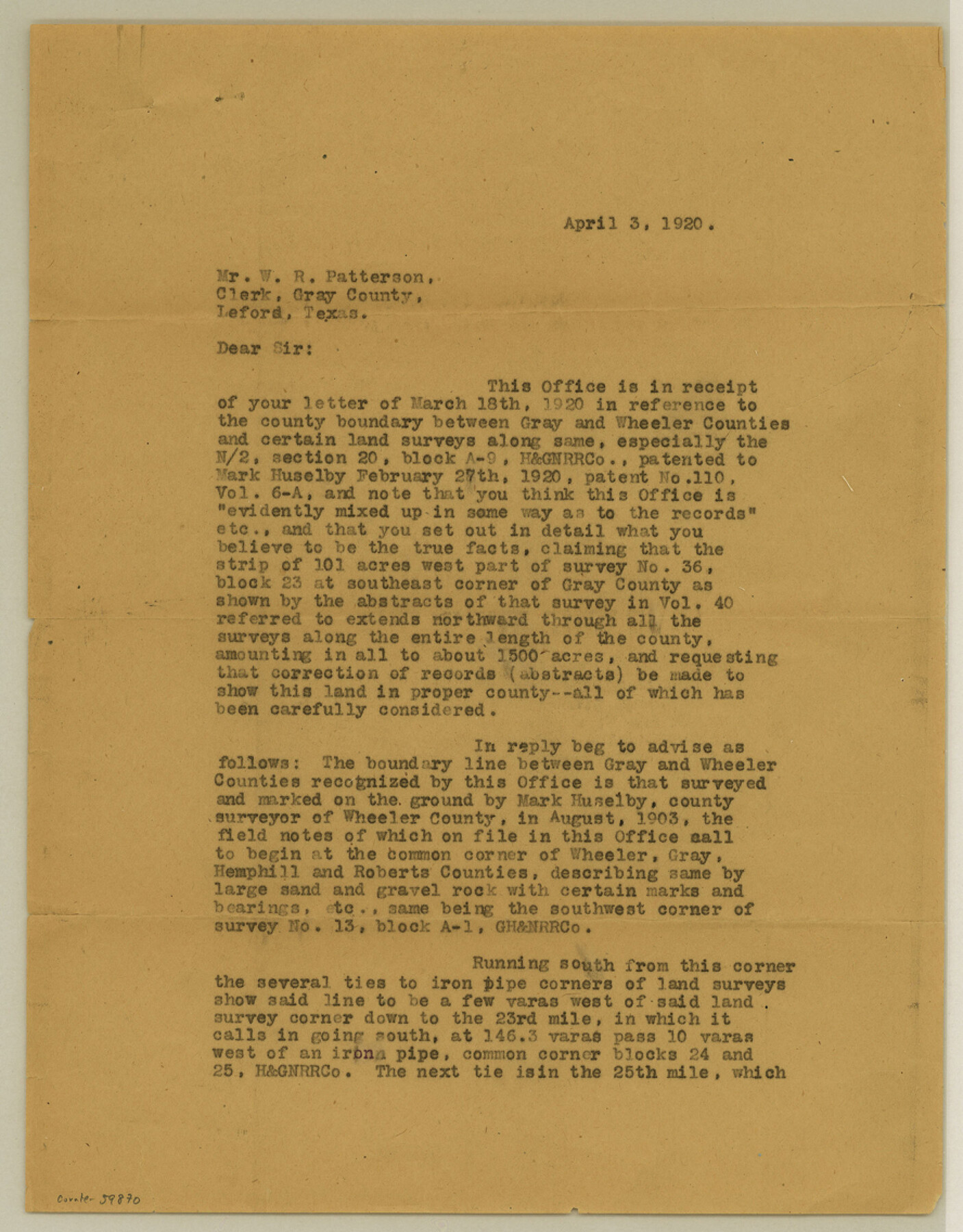
Wheeler County Boundary File 1c
[Letter regarding the County Boundary between Gray and Wheeler Counties]
-
Map/Doc
59870
-
Collection
General Map Collection
-
Counties
Wheeler
-
Subjects
County Boundaries
-
Height x Width
11.4 x 8.9 inches
29.0 x 22.6 cm
Part of: General Map Collection
Colorado County Sketch File 21

Print $8.00
- Digital $50.00
Colorado County Sketch File 21
Size 13.1 x 8.8 inches
Map/Doc 18957
Bosque County Sketch File 17

Print $8.00
- Digital $50.00
Bosque County Sketch File 17
1863
Size 13.0 x 7.9 inches
Map/Doc 14788
Terrell County Working Sketch 9

Print $20.00
- Digital $50.00
Terrell County Working Sketch 9
1917
Size 18.9 x 23.0 inches
Map/Doc 62158
Map of Jack County

Print $20.00
- Digital $50.00
Map of Jack County
1896
Size 22.7 x 27.4 inches
Map/Doc 4571
Coke County Sketch File 6

Print $6.00
- Digital $50.00
Coke County Sketch File 6
1860
Size 7.5 x 10.0 inches
Map/Doc 18582
Northeast Part Presidio County

Print $20.00
- Digital $50.00
Northeast Part Presidio County
1973
Size 41.3 x 32.4 inches
Map/Doc 73265
Calhoun County NRC Article 33.136 Sketch 1

Print $42.00
- Digital $50.00
Calhoun County NRC Article 33.136 Sketch 1
2000
Size 16.8 x 21.7 inches
Map/Doc 61556
[Sketch for Mineral Application 24072, San Jacinto River]
![65609, [Sketch for Mineral Application 24072, San Jacinto River], General Map Collection](https://historictexasmaps.com/wmedia_w700/maps/65609.tif.jpg)
Print $20.00
- Digital $50.00
[Sketch for Mineral Application 24072, San Jacinto River]
1929
Size 8.4 x 13.9 inches
Map/Doc 65609
Crockett County Sketch File 24

Print $10.00
- Digital $50.00
Crockett County Sketch File 24
1881
Size 13.1 x 8.6 inches
Map/Doc 19698
Flight Mission No. DQO-1K, Frame 20, Galveston County

Print $20.00
- Digital $50.00
Flight Mission No. DQO-1K, Frame 20, Galveston County
1952
Size 19.0 x 22.5 inches
Map/Doc 84979
[Sketch for Mineral Application 33721 - 33725 Incl. - Padre and Mustang Island]
![2875, [Sketch for Mineral Application 33721 - 33725 Incl. - Padre and Mustang Island], General Map Collection](https://historictexasmaps.com/wmedia_w700/maps/2875.tif.jpg)
Print $20.00
- Digital $50.00
[Sketch for Mineral Application 33721 - 33725 Incl. - Padre and Mustang Island]
1942
Size 30.9 x 22.0 inches
Map/Doc 2875
Briscoe County Rolled Sketch WL

Print $20.00
- Digital $50.00
Briscoe County Rolled Sketch WL
1936
Size 18.6 x 43.0 inches
Map/Doc 5335
You may also like
Menard County Sketch File 23

Print $20.00
- Digital $50.00
Menard County Sketch File 23
1927
Size 21.2 x 31.1 inches
Map/Doc 12076
Flight Mission No. DAG-24K, Frame 139, Matagorda County

Print $20.00
- Digital $50.00
Flight Mission No. DAG-24K, Frame 139, Matagorda County
1953
Size 18.5 x 22.3 inches
Map/Doc 86557
[County School Land Leagues in Bailey County and Lamb County]
![90971, [County School Land Leagues in Bailey County and Lamb County], Twichell Survey Records](https://historictexasmaps.com/wmedia_w700/maps/90971-2.tif.jpg)
Print $3.00
- Digital $50.00
[County School Land Leagues in Bailey County and Lamb County]
1900
Size 10.9 x 16.6 inches
Map/Doc 90971
[Roosevelt, Quay, and other Counties, N.M.]
![89820, [Roosevelt, Quay, and other Counties, N.M.], Twichell Survey Records](https://historictexasmaps.com/wmedia_w700/maps/89820-1.tif.jpg)
Print $40.00
- Digital $50.00
[Roosevelt, Quay, and other Counties, N.M.]
Size 40.7 x 57.6 inches
Map/Doc 89820

The Chief Justice County of Red River. Lands in Conflict with Nacogdoches County

Print $20.00
The Chief Justice County of Red River. Lands in Conflict with Nacogdoches County
2020
Size 17.4 x 21.8 inches
Map/Doc 96066
Culberson County Working Sketch 17

Print $20.00
- Digital $50.00
Culberson County Working Sketch 17
1927
Size 22.9 x 35.2 inches
Map/Doc 68469
Williamson County Working Sketch 1

Print $20.00
- Digital $50.00
Williamson County Working Sketch 1
Size 18.2 x 23.3 inches
Map/Doc 72561
Val Verde County Working Sketch 96

Print $20.00
- Digital $50.00
Val Verde County Working Sketch 96
1979
Size 38.9 x 36.9 inches
Map/Doc 72231
Culberson County Sketch File 26

Print $8.00
- Digital $50.00
Culberson County Sketch File 26
1949
Size 11.2 x 8.8 inches
Map/Doc 20262
Chart of Yellow Fever in the United States

Print $20.00
- Digital $50.00
Chart of Yellow Fever in the United States
1874
Size 16.3 x 17.2 inches
Map/Doc 95701
Galveston County Rolled Sketch 22

Print $20.00
- Digital $50.00
Galveston County Rolled Sketch 22
1953
Size 28.8 x 39.5 inches
Map/Doc 9663