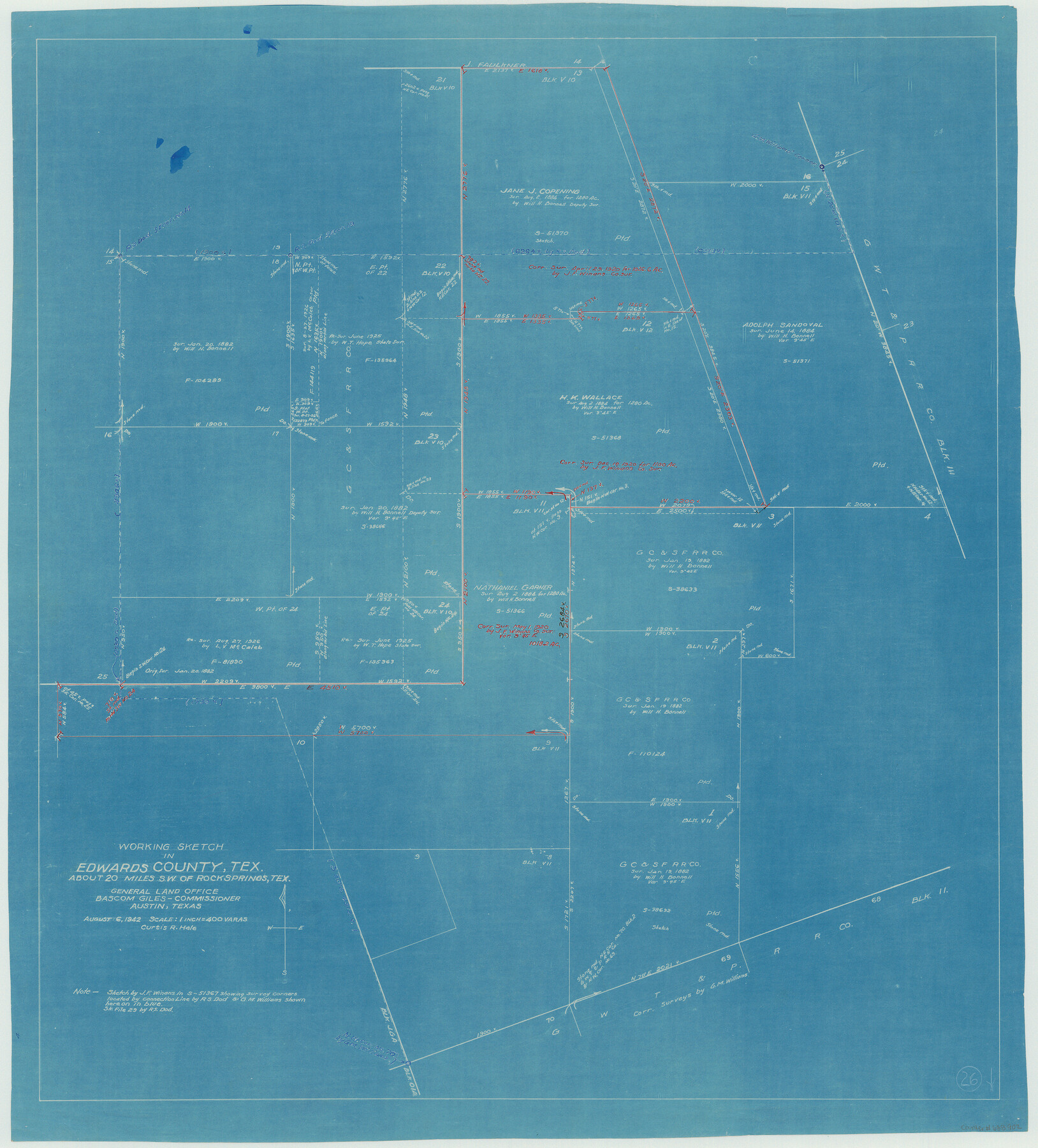
Edwards County Working Sketch 26
-
Map/Doc
68902
-
Collection
General Map Collection
-
Object Dates
8/6/1942 (Creation Date)
-
People and Organizations
Curtis R. Hale (Draftsman)
-
Counties
Edwards
-
Subjects
Surveying Working Sketch
-
Height x Width
31.8 x 28.8 inches
80.8 x 73.2 cm
-
Scale
1" = 400 varas
Part of: General Map Collection
Map of Panola County

Print $20.00
- Digital $50.00
Map of Panola County
1882
Size 20.9 x 22.0 inches
Map/Doc 4504
Irion County Rolled Sketch 13

Print $20.00
- Digital $50.00
Irion County Rolled Sketch 13
1948
Size 27.0 x 30.7 inches
Map/Doc 6323
McMullen County Rolled Sketch 14

Print $20.00
- Digital $50.00
McMullen County Rolled Sketch 14
1946
Size 33.3 x 41.0 inches
Map/Doc 6731
Williamson County Boundary File 2

Print $40.00
- Digital $50.00
Williamson County Boundary File 2
Size 9.0 x 4.2 inches
Map/Doc 59992
Pecos County Rolled Sketch 144

Print $20.00
- Digital $50.00
Pecos County Rolled Sketch 144
1956
Size 28.5 x 29.8 inches
Map/Doc 7277
Montgomery County Sketch File 31

Print $20.00
- Digital $50.00
Montgomery County Sketch File 31
1932
Size 35.2 x 34.1 inches
Map/Doc 10550
Martin County Rolled Sketch 3

Print $20.00
- Digital $50.00
Martin County Rolled Sketch 3
Size 29.2 x 15.4 inches
Map/Doc 6664
Concho County Sketch File 27

Print $8.00
- Digital $50.00
Concho County Sketch File 27
1885
Size 11.3 x 8.8 inches
Map/Doc 19162
Nueces County Rolled Sketch 126 A-G

Print $22.00
- Digital $50.00
Nueces County Rolled Sketch 126 A-G
1998
Size 11.3 x 8.8 inches
Map/Doc 8962
Coleman County Working Sketch 11

Print $20.00
- Digital $50.00
Coleman County Working Sketch 11
1950
Size 24.2 x 18.2 inches
Map/Doc 68077
Mills County Sketch File 4

Print $4.00
- Digital $50.00
Mills County Sketch File 4
Size 8.8 x 8.3 inches
Map/Doc 31648
Winkler County Working Sketch 11

Print $40.00
- Digital $50.00
Winkler County Working Sketch 11
1960
Size 28.5 x 81.4 inches
Map/Doc 72605
You may also like
Upton County Sketch File 28

Print $5.00
- Digital $50.00
Upton County Sketch File 28
1929
Size 22.8 x 31.8 inches
Map/Doc 12521
Stonewall County

Print $20.00
- Digital $50.00
Stonewall County
1889
Size 26.2 x 21.9 inches
Map/Doc 4060
Refugio County Sketch File 14

Print $2.00
- Digital $50.00
Refugio County Sketch File 14
Size 12.8 x 8.1 inches
Map/Doc 35267
Pecos County Working Sketch 140

Print $20.00
- Digital $50.00
Pecos County Working Sketch 140
1983
Size 43.1 x 42.9 inches
Map/Doc 71614
Kaufman County Rolled Sketch 1

Print $20.00
- Digital $50.00
Kaufman County Rolled Sketch 1
1951
Size 26.4 x 34.8 inches
Map/Doc 6456
Pecos County Rolled Sketch 59

Print $20.00
- Digital $50.00
Pecos County Rolled Sketch 59
1922
Size 16.6 x 17.0 inches
Map/Doc 7231
Maverick County Working Sketch 3

Print $20.00
- Digital $50.00
Maverick County Working Sketch 3
1939
Size 34.4 x 24.8 inches
Map/Doc 70895
[Texas State Capitol Land]
![89940, [Texas State Capitol Land], Twichell Survey Records](https://historictexasmaps.com/wmedia_w700/maps/89940-1.tif.jpg)
Print $40.00
- Digital $50.00
[Texas State Capitol Land]
Size 37.6 x 72.6 inches
Map/Doc 89940
Lyons Subdivision North Part Block 79

Print $20.00
- Digital $50.00
Lyons Subdivision North Part Block 79
Size 19.6 x 24.5 inches
Map/Doc 92795
Phelps's National Map of the United States, a Travellers Guide. Embracing the principal railroads, canals, steamboat & stage routes, throughout the Union

Print $20.00
- Digital $50.00
Phelps's National Map of the United States, a Travellers Guide. Embracing the principal railroads, canals, steamboat & stage routes, throughout the Union
1849
Size 20.9 x 26.3 inches
Map/Doc 95901
Anderson County Boundary File 7

Print $10.00
- Digital $50.00
Anderson County Boundary File 7
Size 14.4 x 8.9 inches
Map/Doc 49751
Copy of Surveyor's Field Book, Morris Browning - In Blocks 7, 5 & 4, I&GNRRCo., Hutchinson and Carson Counties, Texas

Print $3.00
- Digital $50.00
Copy of Surveyor's Field Book, Morris Browning - In Blocks 7, 5 & 4, I&GNRRCo., Hutchinson and Carson Counties, Texas
1888
Size 12.7 x 9.7 inches
Map/Doc 62258