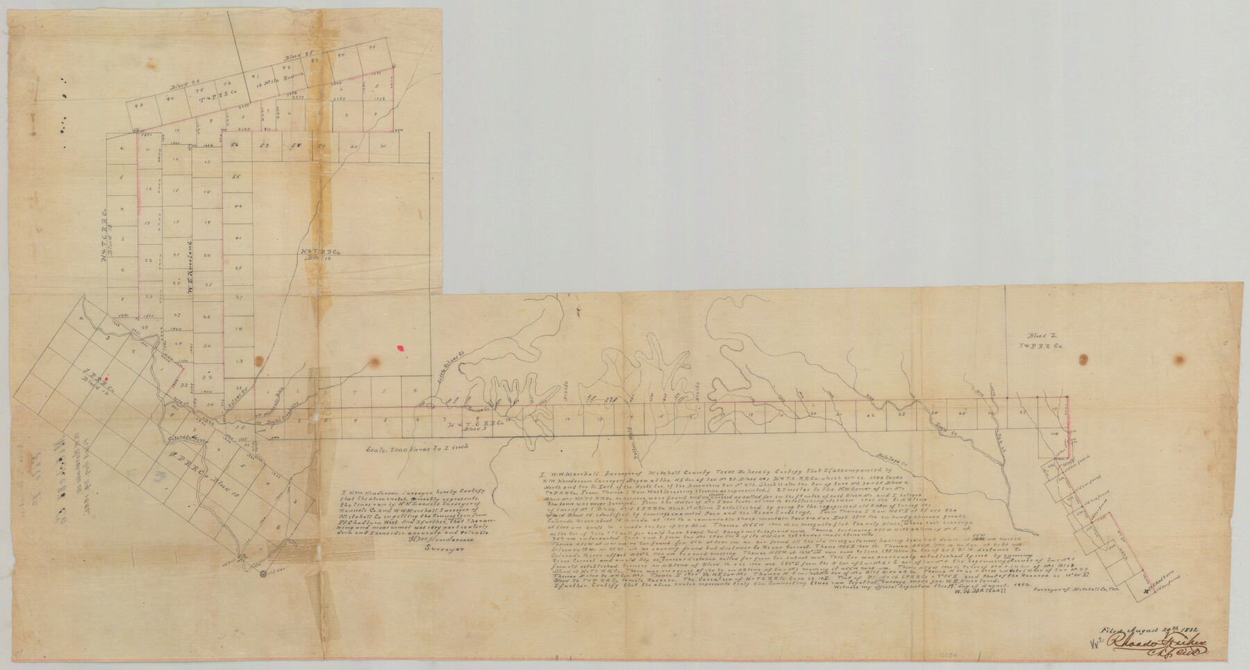
Nolan County Sketch File 1a
[Sketch of large area spanning four counties]
-
Map/Doc
10554
-
Collection
General Map Collection
-
Object Dates
8/19/1882 (Creation Date)
8/29/1882 (File Date)
-
People and Organizations
W.W. Marshall (Surveyor/Engineer)
H.M. Henderson (Surveyor/Engineer)
-
Counties
Nolan Mitchell Coke Sterling
-
Subjects
Surveying Sketch File
-
Height x Width
20.7 x 39.4 inches
52.6 x 100.1 cm
-
Medium
paper, manuscript
-
Scale
1" = 2000 varas
-
Features
Oak Creek
Eagle Creek
Antelope Creek
Yellow Wolf Creek
Little Silver Creek
Silver Creek
Michael's Run [Creek]
Doyle's Creek
Colorado River
Ft. Chadburn [sic]
Part of: General Map Collection
Fannin County

Print $20.00
- Digital $50.00
Fannin County
1946
Size 42.3 x 37.4 inches
Map/Doc 73145
Hardeman County Working Sketch 17

Print $20.00
- Digital $50.00
Hardeman County Working Sketch 17
1986
Size 18.4 x 26.1 inches
Map/Doc 63398
Tarrant County

Print $20.00
- Digital $50.00
Tarrant County
1857
Size 20.9 x 15.4 inches
Map/Doc 4628
Presidio County Working Sketch 127

Print $20.00
- Digital $50.00
Presidio County Working Sketch 127
1987
Size 42.8 x 29.5 inches
Map/Doc 71805
Culberson County Working Sketch 63

Print $20.00
- Digital $50.00
Culberson County Working Sketch 63
1975
Size 34.1 x 24.9 inches
Map/Doc 68517
Andrews County Working Sketch 17

Print $20.00
- Digital $50.00
Andrews County Working Sketch 17
1963
Size 30.7 x 27.1 inches
Map/Doc 67063
Map of the New England or Eastern States (Inset 1: Map of New Brunswick, Nova Scotia and Newfoundland / Inset 2: Vicinity of Boston and Providence / Inset 3: Vicinity of New Haven and Hartford)

Print $20.00
- Digital $50.00
Map of the New England or Eastern States (Inset 1: Map of New Brunswick, Nova Scotia and Newfoundland / Inset 2: Vicinity of Boston and Providence / Inset 3: Vicinity of New Haven and Hartford)
1844
Size 17.8 x 11.8 inches
Map/Doc 93495
Montague County Working Sketch 24

Print $20.00
- Digital $50.00
Montague County Working Sketch 24
1953
Size 21.9 x 27.6 inches
Map/Doc 71090
Starr County Working Sketch 7

Print $20.00
- Digital $50.00
Starr County Working Sketch 7
1938
Size 39.2 x 36.4 inches
Map/Doc 63923
Dickens County Sketch File H

Print $28.00
- Digital $50.00
Dickens County Sketch File H
Size 13.2 x 8.9 inches
Map/Doc 20861
Flight Mission No. CRK-5P, Frame 128, Refugio County

Print $20.00
- Digital $50.00
Flight Mission No. CRK-5P, Frame 128, Refugio County
1956
Size 18.6 x 22.5 inches
Map/Doc 86931
Randall County Boundary File 5a

Print $8.00
- Digital $50.00
Randall County Boundary File 5a
Size 14.3 x 8.8 inches
Map/Doc 58141
You may also like
Waco, Tex., County Seat of McLennan Co.

Print $20.00
Waco, Tex., County Seat of McLennan Co.
1886
Size 23.1 x 32.7 inches
Map/Doc 89212
Howard County Sketch File 3

Print $12.00
- Digital $50.00
Howard County Sketch File 3
1909
Size 9.0 x 8.3 inches
Map/Doc 26855
Flight Mission No. DQN-5K, Frame 148, Calhoun County

Print $20.00
- Digital $50.00
Flight Mission No. DQN-5K, Frame 148, Calhoun County
1953
Size 18.6 x 21.9 inches
Map/Doc 84423
[S. Abercrom and surrounding surveys]
![91016, [S. Abercrom and surrounding surveys], Twichell Survey Records](https://historictexasmaps.com/wmedia_w700/maps/91016-1.tif.jpg)
Print $20.00
- Digital $50.00
[S. Abercrom and surrounding surveys]
Size 27.7 x 21.7 inches
Map/Doc 91016
Liberty County Working Sketch 77

Print $20.00
- Digital $50.00
Liberty County Working Sketch 77
Size 37.4 x 45.9 inches
Map/Doc 70537
Walker County Miscellaneous Sketch 1

Print $20.00
- Digital $50.00
Walker County Miscellaneous Sketch 1
2003
Size 36.0 x 31.3 inches
Map/Doc 88868
Flake Addition a Subdivision of SE Part of NE Quarter Section 4, Block O

Print $20.00
- Digital $50.00
Flake Addition a Subdivision of SE Part of NE Quarter Section 4, Block O
Size 27.4 x 19.5 inches
Map/Doc 92823
Presidio County Working Sketch 2

Print $20.00
- Digital $50.00
Presidio County Working Sketch 2
1907
Size 29.4 x 22.1 inches
Map/Doc 71676
Bird's Eye View of the City of Dallas, Texas

Print $20.00
Bird's Eye View of the City of Dallas, Texas
1872
Size 18.6 x 25.6 inches
Map/Doc 89080
Montgomery County Rolled Sketch 40

Print $393.00
- Digital $50.00
Montgomery County Rolled Sketch 40
1970
Size 10.3 x 16.0 inches
Map/Doc 46793
Sterling County Sketch File 20

Print $12.00
- Digital $50.00
Sterling County Sketch File 20
1952
Size 11.2 x 8.7 inches
Map/Doc 37173
Brewster County Working Sketch 102

Print $20.00
- Digital $50.00
Brewster County Working Sketch 102
1980
Size 40.0 x 43.3 inches
Map/Doc 67702