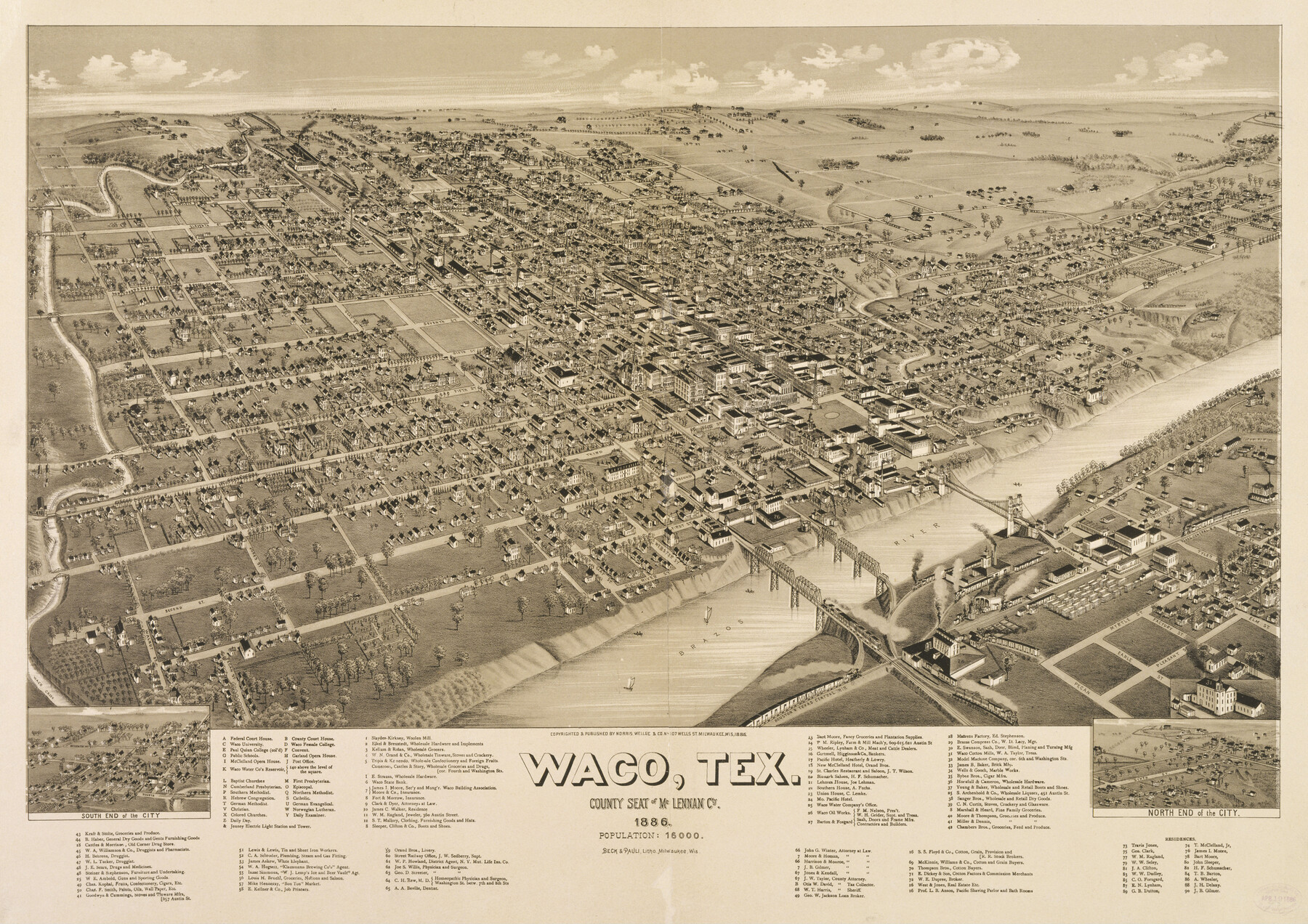
Waco, Tex., County Seat of McLennan Co.
-
Map/Doc
89212
-
Collection
Non-GLO Digital Images
-
Object Dates
1886 (Creation Date)
-
People and Organizations
Norris, Wellge and Company (Publisher)
Beck and Pauli Lithograph (Printer)
-
Counties
McLennan
-
Subjects
Bird's Eye View City Pictorial
-
Height x Width
23.1 x 32.7 inches
58.7 x 83.1 cm
-
Comments
Bird's Eye View map. Public Domain image obtained from Wikimedia Commons.
Part of: Non-GLO Digital Images

Map of the United States Exhibiting the grants of lands made by the general government to aid in the construction of railroads and wagon roads

Print $20.00
Map of the United States Exhibiting the grants of lands made by the general government to aid in the construction of railroads and wagon roads
1878
Size 20.8 x 29.4 inches
Map/Doc 95286
New Map of the City of New York, with Brooklyn & part of Williamsburg

Print $20.00
- Digital $50.00
New Map of the City of New York, with Brooklyn & part of Williamsburg
1839
Size 14.4 x 12.3 inches
Map/Doc 95909
Honey Grove, Tex., Fannin County, 1886

Print $20.00
Honey Grove, Tex., Fannin County, 1886
1886
Size 15.9 x 22.2 inches
Map/Doc 89091
A Geological Map of the United States

Print $20.00
A Geological Map of the United States
Size 10.2 x 15.9 inches
Map/Doc 95281
[WWI Topographic Planning Map of the Ardennes]
![94129, [WWI Topographic Planning Map of the Ardennes], Non-GLO Digital Images](https://historictexasmaps.com/wmedia_w700/maps/94129-1.tif.jpg)
Print $20.00
[WWI Topographic Planning Map of the Ardennes]
1918
Size 35.8 x 20.2 inches
Map/Doc 94129
El Nuevo México y Tierras Adyacentes Levantado para la Demarcación de los Límites de los Dominios Españoles y de los Estados Unidos

El Nuevo México y Tierras Adyacentes Levantado para la Demarcación de los Límites de los Dominios Españoles y de los Estados Unidos
1811
Size 9.4 x 12.6 inches
Map/Doc 94445
Map of Texas from the most recent authorities

Print $20.00
Map of Texas from the most recent authorities
1845
Size 13.5 x 17.1 inches
Map/Doc 94574
Bird's Eye View of La Grange, Fayette County, Texas

Print $20.00
Bird's Eye View of La Grange, Fayette County, Texas
1880
Size 24.1 x 31.2 inches
Map/Doc 89096
[Stephen F. Austin's Map of Texas]
![95825, [Stephen F. Austin's Map of Texas], Non-GLO Digital Images](https://historictexasmaps.com/wmedia_w700/maps/95825.tif.jpg)
[Stephen F. Austin's Map of Texas]
1829
Size 21.7 x 17.9 inches
Map/Doc 95825
Carta geográfica que comprende en su extensión mucha parte del arzobispado de México, y alguna de los obispados de Puebla, Valladolid de Michoacán, Guadalajara y Durango, confinantes entre si

Carta geográfica que comprende en su extensión mucha parte del arzobispado de México, y alguna de los obispados de Puebla, Valladolid de Michoacán, Guadalajara y Durango, confinantes entre si
1779
Size 33.9 x 22.0 inches
Map/Doc 97079

You may also like
Karnes County Sketch File 15

Print $28.00
- Digital $50.00
Karnes County Sketch File 15
1922
Size 11.4 x 8.8 inches
Map/Doc 28618
New Road Between Virginia Point and the City of Houston

Print $20.00
- Digital $50.00
New Road Between Virginia Point and the City of Houston
1843
Size 14.5 x 20.7 inches
Map/Doc 34
Bandera County Working Sketch 53

Print $20.00
- Digital $50.00
Bandera County Working Sketch 53
1985
Size 34.0 x 36.0 inches
Map/Doc 67649
Upton County Rolled Sketch 56

Print $158.00
- Digital $50.00
Upton County Rolled Sketch 56
1934
Size 10.0 x 15.1 inches
Map/Doc 49413
Map of Bandera County

Print $40.00
- Digital $50.00
Map of Bandera County
1885
Size 33.5 x 64.7 inches
Map/Doc 4771
Young County Working Sketch 19

Print $20.00
- Digital $50.00
Young County Working Sketch 19
1961
Size 27.2 x 23.7 inches
Map/Doc 62042
Flight Mission No. BQR-13K, Frame 164, Brazoria County

Print $20.00
- Digital $50.00
Flight Mission No. BQR-13K, Frame 164, Brazoria County
1952
Size 18.8 x 22.4 inches
Map/Doc 84089
Dawson County Working Sketch 18

Print $40.00
- Digital $50.00
Dawson County Working Sketch 18
1963
Size 41.2 x 58.3 inches
Map/Doc 68562
Yoakum County Sketch File 21

Print $2.00
- Digital $50.00
Yoakum County Sketch File 21
2005
Size 8.5 x 14.0 inches
Map/Doc 83597
Flight Mission No. DIX-10P, Frame 75, Aransas County

Print $20.00
- Digital $50.00
Flight Mission No. DIX-10P, Frame 75, Aransas County
1956
Size 18.6 x 22.3 inches
Map/Doc 83936
[T. & P. Blocks 31-33, Township 5N]
![90568, [T. & P. Blocks 31-33, Township 5N], Twichell Survey Records](https://historictexasmaps.com/wmedia_w700/maps/90568-1.tif.jpg)
Print $20.00
- Digital $50.00
[T. & P. Blocks 31-33, Township 5N]
Size 14.6 x 17.7 inches
Map/Doc 90568
Travis County Working Sketch 66

Print $20.00
- Digital $50.00
Travis County Working Sketch 66
2017
Size 24.5 x 36.6 inches
Map/Doc 94122