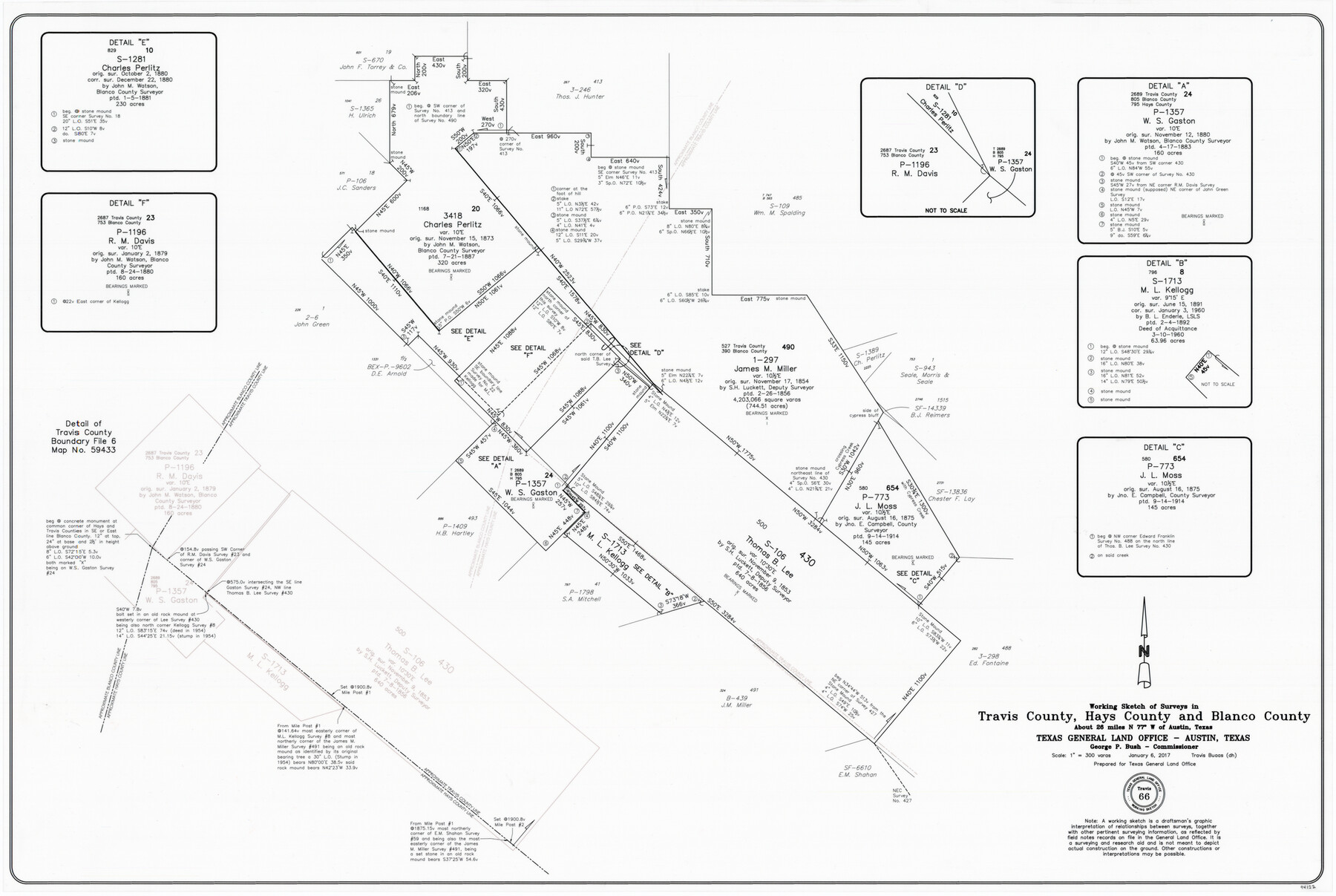
Travis County Working Sketch 66
-
Map/Doc
94122
-
Collection
General Map Collection
-
Object Dates
1/6/2017 (Creation Date)
-
People and Organizations
Travis Buaas (Draftsman)
-
Counties
Travis Hays Blanco
-
Subjects
Surveying Working Sketch
-
Height x Width
24.5 x 36.6 inches
62.2 x 93.0 cm
-
Medium
mylar, print
-
Scale
1" = 300 varas
Part of: General Map Collection
[Houston & Texas Central Ry.]
![64363, [Houston & Texas Central Ry.], General Map Collection](https://historictexasmaps.com/wmedia_w700/maps/64363.tif.jpg)
Print $20.00
- Digital $50.00
[Houston & Texas Central Ry.]
1939
Size 15.5 x 13.8 inches
Map/Doc 64363
Bandera County Working Sketch 54

Print $20.00
- Digital $50.00
Bandera County Working Sketch 54
1988
Size 30.4 x 30.1 inches
Map/Doc 67650
Bell County Sketch File 29a

Print $4.00
- Digital $50.00
Bell County Sketch File 29a
1875
Size 12.4 x 8.6 inches
Map/Doc 14441
Hemphill County Working Sketch 24

Print $40.00
- Digital $50.00
Hemphill County Working Sketch 24
1974
Size 48.6 x 37.4 inches
Map/Doc 66119
Loving County Working Sketch 26

Print $40.00
- Digital $50.00
Loving County Working Sketch 26
2014
Size 33.3 x 48.0 inches
Map/Doc 93681
Bastrop County

Print $20.00
- Digital $50.00
Bastrop County
1872
Size 21.1 x 17.4 inches
Map/Doc 3279
Fort Bend County Sketch File 19

Print $4.00
- Digital $50.00
Fort Bend County Sketch File 19
1890
Size 13.0 x 8.7 inches
Map/Doc 22951
San Patricio County Rolled Sketch 31

Print $20.00
- Digital $50.00
San Patricio County Rolled Sketch 31
1941
Size 43.1 x 42.6 inches
Map/Doc 9898
Baylor County Sketch File A1

Print $40.00
- Digital $50.00
Baylor County Sketch File A1
1899
Size 22.8 x 17.3 inches
Map/Doc 10911
Grimes County Working Sketch 3

Print $20.00
- Digital $50.00
Grimes County Working Sketch 3
1946
Size 34.1 x 29.1 inches
Map/Doc 63294
Gaines County Rolled Sketch 15A

Print $40.00
- Digital $50.00
Gaines County Rolled Sketch 15A
Size 90.5 x 23.8 inches
Map/Doc 9036
Flight Mission No. CRC-6R, Frame 37, Chambers County

Print $20.00
- Digital $50.00
Flight Mission No. CRC-6R, Frame 37, Chambers County
1956
Size 18.5 x 22.4 inches
Map/Doc 84970
You may also like
Chambers County Rolled Sketch FD

Print $20.00
- Digital $50.00
Chambers County Rolled Sketch FD
1935
Size 32.7 x 26.5 inches
Map/Doc 5433
General Highway Map, Gaines County, Texas

Print $20.00
- Digital $50.00
General Highway Map, Gaines County, Texas
1951
Size 18.8 x 25.9 inches
Map/Doc 92639
[Block D3, Block A, Block O]
![92750, [Block D3, Block A, Block O], Twichell Survey Records](https://historictexasmaps.com/wmedia_w700/maps/92750-1.tif.jpg)
Print $20.00
- Digital $50.00
[Block D3, Block A, Block O]
Size 25.2 x 13.1 inches
Map/Doc 92750
General Highway Map, Matagorda County, Texas

Print $20.00
General Highway Map, Matagorda County, Texas
1939
Size 24.7 x 18.3 inches
Map/Doc 79187
Flight Mission No. BRA-7M, Frame 20, Jefferson County

Print $20.00
- Digital $50.00
Flight Mission No. BRA-7M, Frame 20, Jefferson County
1953
Size 18.6 x 22.2 inches
Map/Doc 85471
Val Verde County Sketch File Z23

Print $6.00
- Digital $50.00
Val Verde County Sketch File Z23
1919
Size 7.3 x 8.8 inches
Map/Doc 39166
Houston County Working Sketch 8

Print $20.00
- Digital $50.00
Houston County Working Sketch 8
1936
Size 41.6 x 30.5 inches
Map/Doc 66238
Limestone County Sketch File 2

Print $2.00
- Digital $50.00
Limestone County Sketch File 2
Size 8.0 x 6.2 inches
Map/Doc 30157
Stonewall County Sketch File 15

Print $40.00
- Digital $50.00
Stonewall County Sketch File 15
1905
Size 14.3 x 8.7 inches
Map/Doc 37255
Texas Gulf Coast Map from the Sabine River to the Rio Grande as subdivided for mineral development

Print $40.00
- Digital $50.00
Texas Gulf Coast Map from the Sabine River to the Rio Grande as subdivided for mineral development
1948
Size 42.6 x 54.3 inches
Map/Doc 2907
Flight Mission No. BRE-2P, Frame 42, Nueces County

Print $20.00
- Digital $50.00
Flight Mission No. BRE-2P, Frame 42, Nueces County
1956
Size 18.5 x 22.4 inches
Map/Doc 86744
