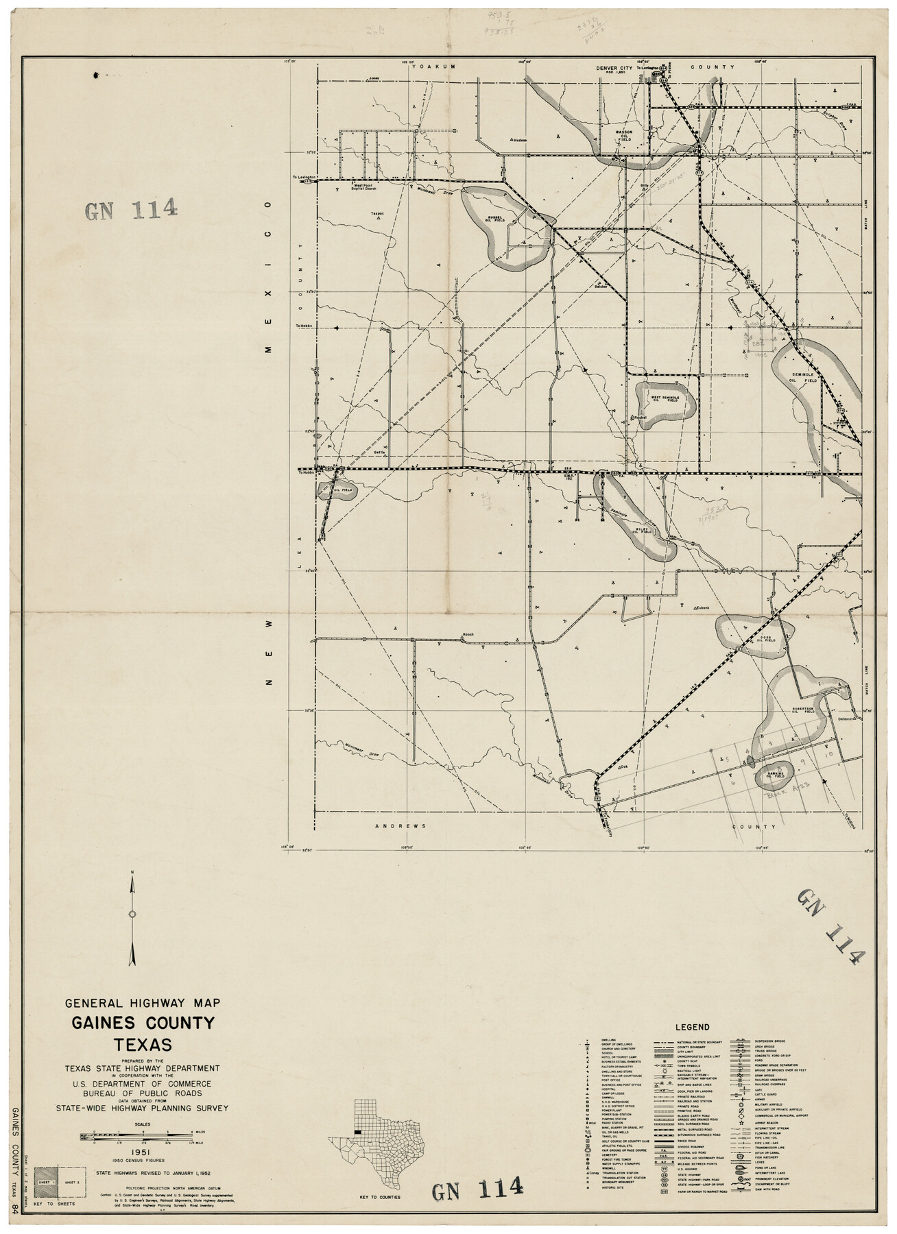
General Highway Map, Gaines County, Texas
GN114
-
Map/Doc
92639
-
Collection
Twichell Survey Records
-
Object Dates
1951 (Creation Date)
-
Counties
Gaines
-
Subjects
County
-
Height x Width
18.8 x 25.9 inches
47.8 x 65.8 cm
Part of: Twichell Survey Records
[Geo. W. Woodley, W. B. Ralls, Boyd Bros. and surrounding surveys]
![90455, [Geo. W. Woodley, W. B. Ralls, Boyd Bros. and surrounding surveys], Twichell Survey Records](https://historictexasmaps.com/wmedia_w700/maps/90455-1.tif.jpg)
Print $3.00
- Digital $50.00
[Geo. W. Woodley, W. B. Ralls, Boyd Bros. and surrounding surveys]
Size 11.7 x 12.6 inches
Map/Doc 90455
[Capitol Leagues 217-228, 238, and vicinity]
![90674, [Capitol Leagues 217-228, 238, and vicinity], Twichell Survey Records](https://historictexasmaps.com/wmedia_w700/maps/90674-1.tif.jpg)
Print $20.00
- Digital $50.00
[Capitol Leagues 217-228, 238, and vicinity]
Size 22.8 x 10.0 inches
Map/Doc 90674
Puckett Suburban Homes in Section 4, Block O

Print $20.00
- Digital $50.00
Puckett Suburban Homes in Section 4, Block O
Size 26.2 x 13.3 inches
Map/Doc 92771
[Block O1, Godair]
![90565, [Block O1, Godair], Twichell Survey Records](https://historictexasmaps.com/wmedia_w700/maps/90565-1.tif.jpg)
Print $20.00
- Digital $50.00
[Block O1, Godair]
Size 22.6 x 17.7 inches
Map/Doc 90565
[G. & M. Block O, M. B. & A. Block N, PSL Blocks B-19 and B-29 showing alleged vacancy]
![89812, [G. & M. Block O, M. B. & A. Block N, PSL Blocks B-19 and B-29 showing alleged vacancy], Twichell Survey Records](https://historictexasmaps.com/wmedia_w700/maps/89812-1.tif.jpg)
Print $40.00
- Digital $50.00
[G. & M. Block O, M. B. & A. Block N, PSL Blocks B-19 and B-29 showing alleged vacancy]
Size 72.2 x 36.9 inches
Map/Doc 89812
[Sketch of T.&P. Blocks 31-34, Tsp. 3N & 4N]
![89746, [Sketch of T.&P. Blocks 31-34, Tsp. 3N & 4N], Twichell Survey Records](https://historictexasmaps.com/wmedia_w700/maps/89746-1.tif.jpg)
Print $20.00
- Digital $50.00
[Sketch of T.&P. Blocks 31-34, Tsp. 3N & 4N]
Size 42.9 x 32.2 inches
Map/Doc 89746
Highway Addition to Littlefield, Texas

Print $3.00
- Digital $50.00
Highway Addition to Littlefield, Texas
Size 14.3 x 11.7 inches
Map/Doc 92266
[Sketch of 27 1/2 Acre Tract]
![92799, [Sketch of 27 1/2 Acre Tract], Twichell Survey Records](https://historictexasmaps.com/wmedia_w700/maps/92799-1.tif.jpg)
Print $3.00
- Digital $50.00
[Sketch of 27 1/2 Acre Tract]
1940
Size 12.4 x 9.1 inches
Map/Doc 92799
[Sketch showing J.S. Brooks, W.B. Aldredge, Madison County School Land and Others]
![89730, [Sketch showing J.S. Brooks, W.B. Aldredge, Madison County School Land and Others], Twichell Survey Records](https://historictexasmaps.com/wmedia_w700/maps/89730-1.tif.jpg)
Print $20.00
- Digital $50.00
[Sketch showing J.S. Brooks, W.B. Aldredge, Madison County School Land and Others]
Size 37.1 x 39.9 inches
Map/Doc 89730
[Leagues 70, 71, 72, 73, 74, 75, 704, 705, 718, 719, and 732]
![91099, [Leagues 70, 71, 72, 73, 74, 75, 704, 705, 718, 719, and 732], Twichell Survey Records](https://historictexasmaps.com/wmedia_w700/maps/91099-1.tif.jpg)
Print $2.00
- Digital $50.00
[Leagues 70, 71, 72, 73, 74, 75, 704, 705, 718, 719, and 732]
Size 6.7 x 12.1 inches
Map/Doc 91099
Winkler Co., Tex., standard single county oil development survey

Print $20.00
- Digital $50.00
Winkler Co., Tex., standard single county oil development survey
Size 14.5 x 16.4 inches
Map/Doc 91972
[Pencil sketch around J. Walters, J. G. Welchmeyer, R. Gage surveys]
![90206, [Pencil sketch around J. Walters, J. G. Welchmeyer, R. Gage surveys], Twichell Survey Records](https://historictexasmaps.com/wmedia_w700/maps/90206-1.tif.jpg)
Print $20.00
- Digital $50.00
[Pencil sketch around J. Walters, J. G. Welchmeyer, R. Gage surveys]
Size 25.5 x 21.7 inches
Map/Doc 90206
You may also like
Bowie County Working Sketch 13

Print $20.00
- Digital $50.00
Bowie County Working Sketch 13
1959
Size 36.9 x 37.0 inches
Map/Doc 67417
Amended Plat New Hobbs Addition to New Hobbs, Lea County, New Mexico

Print $20.00
- Digital $50.00
Amended Plat New Hobbs Addition to New Hobbs, Lea County, New Mexico
Size 24.1 x 18.5 inches
Map/Doc 92418
DeWitt County Rolled Sketch 2

Print $20.00
- Digital $50.00
DeWitt County Rolled Sketch 2
1943
Size 32.0 x 42.7 inches
Map/Doc 8778
[Sketch of Blocks C2, C, D7, A, RG and San Augustine County School Land]
![93021, [Sketch of Blocks C2, C, D7, A, RG and San Augustine County School Land], Twichell Survey Records](https://historictexasmaps.com/wmedia_w700/maps/93021-1.tif.jpg)
Print $20.00
- Digital $50.00
[Sketch of Blocks C2, C, D7, A, RG and San Augustine County School Land]
Size 15.5 x 25.8 inches
Map/Doc 93021
Webb County Sketch File B3

Print $40.00
- Digital $50.00
Webb County Sketch File B3
1892
Size 8.9 x 4.2 inches
Map/Doc 39658
Survey in South Austin for Mr. R.N. Graham

Print $20.00
- Digital $50.00
Survey in South Austin for Mr. R.N. Graham
Map/Doc 93795
Donley County Sketch File 12

Print $2.00
- Digital $50.00
Donley County Sketch File 12
Size 12.9 x 8.2 inches
Map/Doc 21248
Scurry County

Print $20.00
- Digital $50.00
Scurry County
1921
Size 41.4 x 38.1 inches
Map/Doc 73286
Fractional Township No. 9 South Range No. 9 East of the Indian Meridian, Indian Territory

Print $20.00
- Digital $50.00
Fractional Township No. 9 South Range No. 9 East of the Indian Meridian, Indian Territory
1898
Size 19.2 x 24.4 inches
Map/Doc 75216
Map of Kerr County

Print $40.00
- Digital $50.00
Map of Kerr County
1895
Size 39.7 x 48.9 inches
Map/Doc 5002
Gillespie County Sketch File 9

Print $4.00
- Digital $50.00
Gillespie County Sketch File 9
1873
Size 8.2 x 10.5 inches
Map/Doc 24145
[Map of Terrell County]
![4074, [Map of Terrell County], General Map Collection](https://historictexasmaps.com/wmedia_w700/maps/4074.tif.jpg)
Print $20.00
- Digital $50.00
[Map of Terrell County]
Size 38.0 x 24.0 inches
Map/Doc 4074