Baylor County Sketch File A1
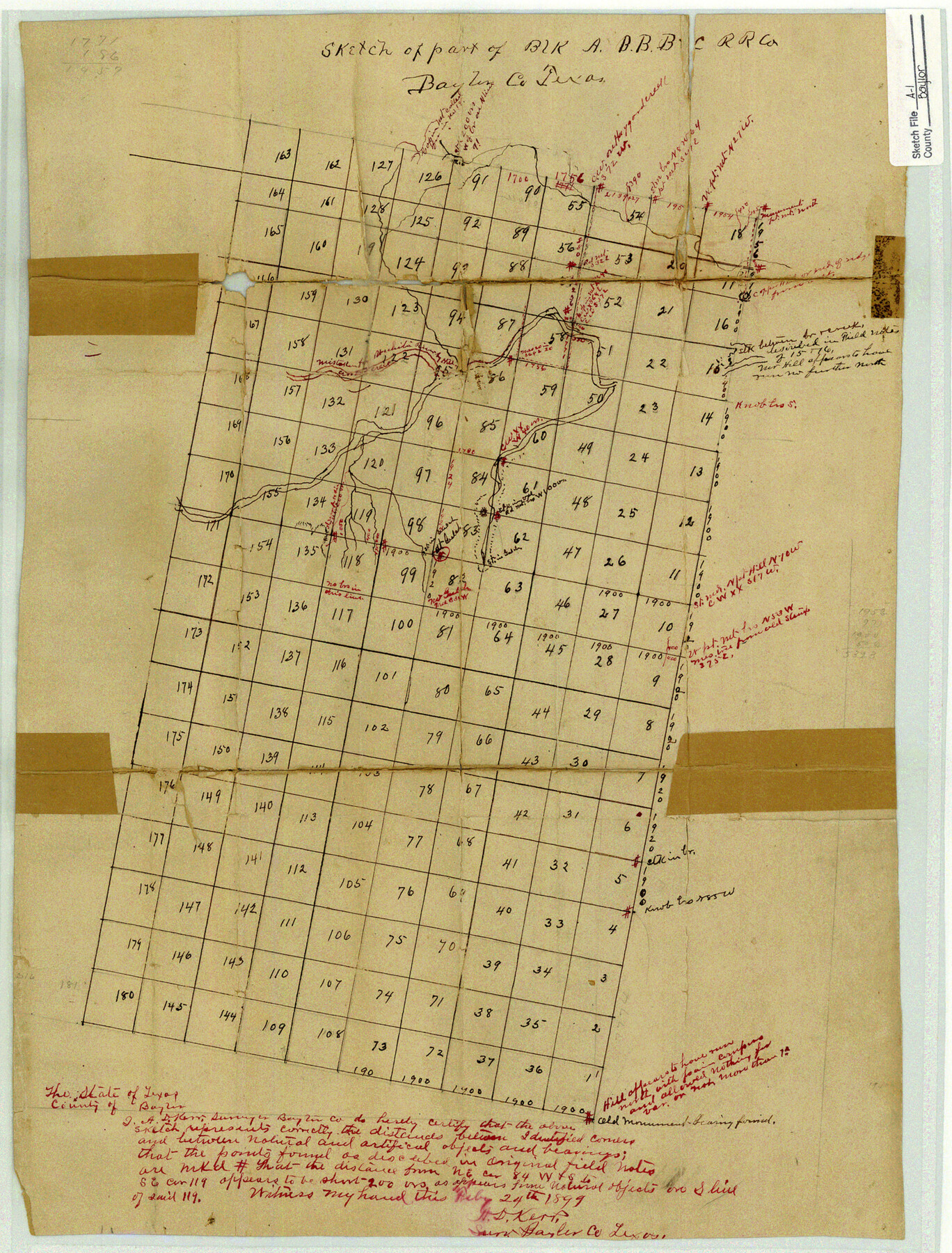
Sketch of part of Blk. A, B. B. B. C. R.R. Co.
-
Map/Doc
10911
-
Collection
General Map Collection
-
Object Dates
1899/2/24 (Creation Date)
1899/3/20 (File Date)
-
People and Organizations
A.D. Kerr (Surveyor/Engineer)
-
Counties
Baylor
-
Subjects
Surveying Sketch File
-
Height x Width
22.8 x 17.3 inches
57.9 x 43.9 cm
-
Medium
paper, manuscript
-
Features
Crooked Creek
Part of: General Map Collection
Kendall County Working Sketch 11

Print $20.00
- Digital $50.00
Kendall County Working Sketch 11
1954
Size 34.0 x 24.8 inches
Map/Doc 66683
Map of Freestone County

Print $20.00
- Digital $50.00
Map of Freestone County
1874
Size 21.8 x 24.5 inches
Map/Doc 3563
Schleicher County Sketch File 8

Print $32.00
- Digital $50.00
Schleicher County Sketch File 8
1881
Size 12.5 x 8.2 inches
Map/Doc 36479
Hale County Sketch File 15

Print $20.00
- Digital $50.00
Hale County Sketch File 15
Size 22.7 x 18.6 inches
Map/Doc 11596
[Plat and field notes of 3.107 acre tract for Clement Cove Harbor Company]

Print $2.00
- Digital $50.00
[Plat and field notes of 3.107 acre tract for Clement Cove Harbor Company]
1987
Size 13.7 x 8.5 inches
Map/Doc 60398
University Lands, Blocks 38 to 57, Crockett, Reagan, Irion, Schleicher Counties

Print $40.00
- Digital $50.00
University Lands, Blocks 38 to 57, Crockett, Reagan, Irion, Schleicher Counties
Size 34.0 x 53.0 inches
Map/Doc 62946
Duval County Sketch File 80

Print $32.00
- Digital $50.00
Duval County Sketch File 80
Size 14.1 x 8.9 inches
Map/Doc 21492
Montgomery County

Print $20.00
- Digital $50.00
Montgomery County
1871
Size 21.0 x 24.6 inches
Map/Doc 3891
Rusk County Sketch File 32

Print $20.00
Rusk County Sketch File 32
1949
Size 33.5 x 28.4 inches
Map/Doc 10596
Foard County Working Sketch 13

Print $40.00
- Digital $50.00
Foard County Working Sketch 13
1981
Size 44.0 x 51.2 inches
Map/Doc 69204
Young County Sketch File 6

Print $14.00
- Digital $50.00
Young County Sketch File 6
Size 13.0 x 8.2 inches
Map/Doc 40852
Aransas County Rolled Sketch 1

Print $40.00
- Digital $50.00
Aransas County Rolled Sketch 1
1930
Size 11.5 x 49.5 inches
Map/Doc 10685
You may also like

Stonewall County Working Sketch 7

Print $20.00
- Digital $50.00
Stonewall County Working Sketch 7
1949
Size 30.7 x 24.5 inches
Map/Doc 62314
Donley County Working Sketch 4

Print $20.00
- Digital $50.00
Donley County Working Sketch 4
1958
Size 44.0 x 39.8 inches
Map/Doc 68737
Rand, McNally & Co.'s Texas

Print $20.00
- Digital $50.00
Rand, McNally & Co.'s Texas
1895
Size 21.2 x 28.6 inches
Map/Doc 95885
Roberts County Sketch File 7

Print $16.00
- Digital $50.00
Roberts County Sketch File 7
1992
Size 14.3 x 8.8 inches
Map/Doc 35316
Zavala County Rolled Sketch 12

Print $20.00
- Digital $50.00
Zavala County Rolled Sketch 12
Size 33.4 x 21.0 inches
Map/Doc 8320
Burnet County Working Sketch 21

Print $20.00
- Digital $50.00
Burnet County Working Sketch 21
1983
Size 47.6 x 28.4 inches
Map/Doc 67864

Bailey County Rolled Sketch RSH

Print $20.00
- Digital $50.00
Bailey County Rolled Sketch RSH
1907
Size 34.3 x 23.3 inches
Map/Doc 5112
Crockett County Rolled Sketch 37

Print $20.00
- Digital $50.00
Crockett County Rolled Sketch 37
Size 36.7 x 29.3 inches
Map/Doc 5589
Flight Mission No. CON-4R, Frame 200, Stonewall County

Print $20.00
- Digital $50.00
Flight Mission No. CON-4R, Frame 200, Stonewall County
1957
Size 18.2 x 22.0 inches
Map/Doc 86994
Freestone County Rolled Sketch 12A

Print $40.00
- Digital $50.00
Freestone County Rolled Sketch 12A
1987
Size 35.2 x 48.6 inches
Map/Doc 8897