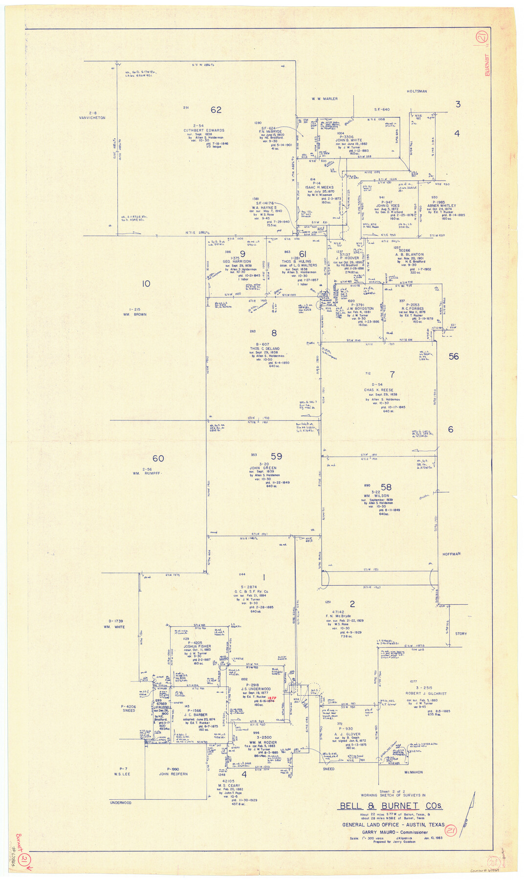
Burnet County Working Sketch 21
-
Map/Doc
67864
-
Collection
General Map Collection
-
Object Dates
1/10/1983 (Creation Date)
-
People and Organizations
Joan Kilpatrick (Draftsman)
-
Counties
Burnet Bell
-
Subjects
Surveying Working Sketch
-
Height x Width
47.6 x 28.4 inches
120.9 x 72.1 cm
-
Scale
1" = 300 varas
Part of: General Map Collection

Bandera County Sketch File 36

Print $6.00
- Digital $50.00
Bandera County Sketch File 36
Size 11.4 x 8.9 inches
Map/Doc 14034
Cass County Working Sketch 40

Print $20.00
- Digital $50.00
Cass County Working Sketch 40
1984
Size 24.6 x 24.5 inches
Map/Doc 67943
Floyd County Working Sketch 8

Print $20.00
- Digital $50.00
Floyd County Working Sketch 8
1931
Size 20.8 x 15.9 inches
Map/Doc 69187
Zavala County Rolled Sketch 18

Print $20.00
- Digital $50.00
Zavala County Rolled Sketch 18
Size 39.4 x 27.3 inches
Map/Doc 8322
Terrell County Working Sketch 64

Print $20.00
- Digital $50.00
Terrell County Working Sketch 64
1971
Size 29.3 x 27.7 inches
Map/Doc 69585
Foard County Sketch File X

Print $20.00
- Digital $50.00
Foard County Sketch File X
1882
Size 15.8 x 17.3 inches
Map/Doc 11499

Brewster County Rolled Sketch 114

Print $20.00
- Digital $50.00
Brewster County Rolled Sketch 114
1964
Size 11.4 x 18.4 inches
Map/Doc 5277
Tyler County Sketch File 6-3

Print $20.00
- Digital $50.00
Tyler County Sketch File 6-3
1861
Size 20.0 x 22.1 inches
Map/Doc 12499
Flight Mission No. DAG-24K, Frame 135, Matagorda County

Print $20.00
- Digital $50.00
Flight Mission No. DAG-24K, Frame 135, Matagorda County
1953
Size 18.4 x 22.2 inches
Map/Doc 86553
Webb County Sketch File 73

Print $20.00
- Digital $50.00
Webb County Sketch File 73
2020
Size 11.0 x 8.5 inches
Map/Doc 95917
You may also like
Howard County Working Sketch 3

Print $20.00
- Digital $50.00
Howard County Working Sketch 3
1904
Size 26.8 x 20.1 inches
Map/Doc 66269
Galveston/Galveston Island, Texas

Galveston/Galveston Island, Texas
Size 18.4 x 24.2 inches
Map/Doc 94345
Lavaca County Working Sketch 19

Print $20.00
- Digital $50.00
Lavaca County Working Sketch 19
1980
Size 26.9 x 29.6 inches
Map/Doc 70372
Williamson County

Print $40.00
- Digital $50.00
Williamson County
1946
Size 40.1 x 57.7 inches
Map/Doc 63130
Wheeler County

Print $20.00
- Digital $50.00
Wheeler County
1932
Size 41.7 x 38.0 inches
Map/Doc 73322
Map of Kinney County

Print $20.00
- Digital $50.00
Map of Kinney County
1876
Size 24.0 x 32.4 inches
Map/Doc 3775
Gaines County Rolled Sketch 34

Print $20.00
- Digital $50.00
Gaines County Rolled Sketch 34
2002
Size 20.1 x 22.3 inches
Map/Doc 77533
Newton County Rolled Sketch 5

Print $20.00
- Digital $50.00
Newton County Rolled Sketch 5
Size 20.5 x 42.5 inches
Map/Doc 6841
Right of Way and Track Map - Houston & Texas Central R.R. operated by the T. and N. O. R.R. Co. - Fort Worth Branch

Print $40.00
- Digital $50.00
Right of Way and Track Map - Houston & Texas Central R.R. operated by the T. and N. O. R.R. Co. - Fort Worth Branch
1918
Size 26.5 x 58.3 inches
Map/Doc 82861
[Block RG, Sections 1, 2, and 16, North Line of San Augustine County School Land]
![91392, [Block RG, Sections 1, 2, and 16, North Line of San Augustine County School Land], Twichell Survey Records](https://historictexasmaps.com/wmedia_w700/maps/91392-1.tif.jpg)
Print $20.00
- Digital $50.00
[Block RG, Sections 1, 2, and 16, North Line of San Augustine County School Land]
Size 25.7 x 12.4 inches
Map/Doc 91392
Terrell County Sketch File 35

Print $36.00
- Digital $50.00
Terrell County Sketch File 35
1957
Size 32.0 x 37.6 inches
Map/Doc 10389
Flight Mission No. CGI-1N, Frame 177, Cameron County

Print $20.00
- Digital $50.00
Flight Mission No. CGI-1N, Frame 177, Cameron County
1955
Size 18.5 x 17.6 inches
Map/Doc 84512