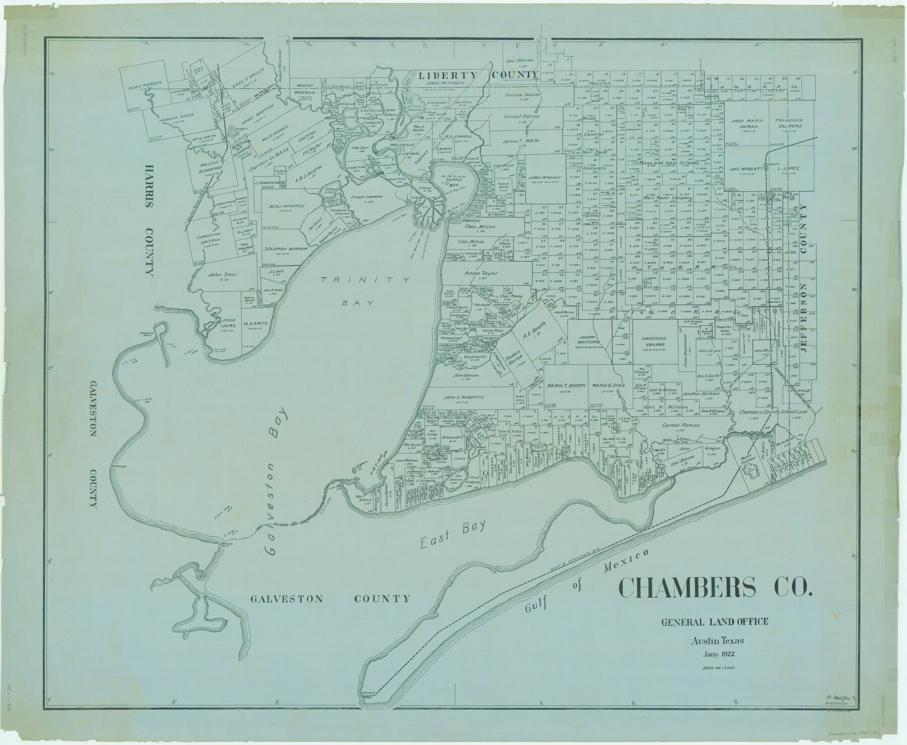
Chambers Co.
RM-1-36
-
Map/Doc
1798
-
Collection
General Map Collection
-
Object Dates
1922 (Creation Date)
-
People and Organizations
Texas General Land Office (Publisher)
Fr. Matzow (Draftsman)
Fr. Matzow (Compiler)
-
Counties
Chambers
-
Subjects
County
-
Height x Width
41.7 x 50.8 inches
105.9 x 129.0 cm
Part of: General Map Collection
Loving County Rolled Sketch 1

Print $40.00
- Digital $50.00
Loving County Rolled Sketch 1
Size 42.5 x 79.5 inches
Map/Doc 9460
Duval County Working Sketch 58

Print $20.00
- Digital $50.00
Duval County Working Sketch 58
Size 21.0 x 33.0 inches
Map/Doc 67498
Galveston County Sketch File 45

Print $20.00
- Digital $50.00
Galveston County Sketch File 45
1930
Size 19.5 x 23.2 inches
Map/Doc 11540
Morris County Rolled Sketch 2A

Print $20.00
- Digital $50.00
Morris County Rolled Sketch 2A
Size 33.5 x 22.8 inches
Map/Doc 10263
Upton County Sketch File 30

Print $5.00
- Digital $50.00
Upton County Sketch File 30
1887
Size 21.0 x 31.6 inches
Map/Doc 12522
[Sketch for Mineral Application 24072, San Jacinto River]
![65593, [Sketch for Mineral Application 24072, San Jacinto River], General Map Collection](https://historictexasmaps.com/wmedia_w700/maps/65593.tif.jpg)
Print $20.00
- Digital $50.00
[Sketch for Mineral Application 24072, San Jacinto River]
1929
Size 19.1 x 16.9 inches
Map/Doc 65593
F. W. & D. C. Ry. Co. Alignment and Right of Way Map, Clay County

Print $20.00
- Digital $50.00
F. W. & D. C. Ry. Co. Alignment and Right of Way Map, Clay County
1927
Size 11.8 x 18.7 inches
Map/Doc 64744
Flight Mission No. DCL-6C, Frame 129, Kenedy County

Print $20.00
- Digital $50.00
Flight Mission No. DCL-6C, Frame 129, Kenedy County
1943
Size 18.5 x 22.3 inches
Map/Doc 85959
Crane County Working Sketch 22

Print $20.00
- Digital $50.00
Crane County Working Sketch 22
1961
Size 44.7 x 43.9 inches
Map/Doc 68299
Houston County Sketch File 41

Print $6.00
- Digital $50.00
Houston County Sketch File 41
1845
Size 16.0 x 10.2 inches
Map/Doc 26828
Clay County Boundary File 17

Print $8.00
- Digital $50.00
Clay County Boundary File 17
Size 13.8 x 8.4 inches
Map/Doc 51432
Tom Green County Working Sketch 9

Print $20.00
- Digital $50.00
Tom Green County Working Sketch 9
1951
Size 31.3 x 42.2 inches
Map/Doc 69378
You may also like
Gonzales County Working Sketch 2

Print $20.00
- Digital $50.00
Gonzales County Working Sketch 2
1920
Size 17.6 x 21.5 inches
Map/Doc 63217
Montgomery County Rolled Sketch 16

Print $20.00
- Digital $50.00
Montgomery County Rolled Sketch 16
Size 28.5 x 26.6 inches
Map/Doc 6804
Clay County Sketch File 45

Print $20.00
- Digital $50.00
Clay County Sketch File 45
Size 23.5 x 35.4 inches
Map/Doc 11097
Kinney County Sketch File 28

Print $8.00
- Digital $50.00
Kinney County Sketch File 28
1929
Size 11.3 x 9.0 inches
Map/Doc 29167
Val Verde County Sketch File 21A

Print $20.00
- Digital $50.00
Val Verde County Sketch File 21A
Size 25.9 x 43.8 inches
Map/Doc 10419
Bosque County Sketch File 5

Print $6.00
- Digital $50.00
Bosque County Sketch File 5
1847
Size 15.7 x 10.4 inches
Map/Doc 14746
[Sketch of Blocks Z and 194, showing tie lines with Runnels County School Land survey]
![91665, [Sketch of Blocks Z and 194, showing tie lines with Runnels County School Land survey], Twichell Survey Records](https://historictexasmaps.com/wmedia_w700/maps/91665-1.tif.jpg)
Print $20.00
- Digital $50.00
[Sketch of Blocks Z and 194, showing tie lines with Runnels County School Land survey]
Size 21.5 x 15.5 inches
Map/Doc 91665
[Folder for] Nautical Chart 11305: Texas Intracoastal Waterway, Laguna Madre, Rincon de San Jose to Chubby Island
![75913, [Folder for] Nautical Chart 11305: Texas Intracoastal Waterway, Laguna Madre, Rincon de San Jose to Chubby Island, General Map Collection](https://historictexasmaps.com/wmedia_w700/maps/75913-1.tif.jpg)
Print $20.00
- Digital $50.00
[Folder for] Nautical Chart 11305: Texas Intracoastal Waterway, Laguna Madre, Rincon de San Jose to Chubby Island
1976
Size 16.0 x 19.0 inches
Map/Doc 75913
Reagan County Rolled Sketch 20

Print $20.00
- Digital $50.00
Reagan County Rolled Sketch 20
1948
Size 45.8 x 45.0 inches
Map/Doc 9814
McMullen County Working Sketch 47

Print $40.00
- Digital $50.00
McMullen County Working Sketch 47
1983
Size 55.8 x 43.3 inches
Map/Doc 70748

Flight Mission No. BRA-6M, Frame 151, Jefferson County

Print $20.00
- Digital $50.00
Flight Mission No. BRA-6M, Frame 151, Jefferson County
1953
Size 18.6 x 22.1 inches
Map/Doc 85452