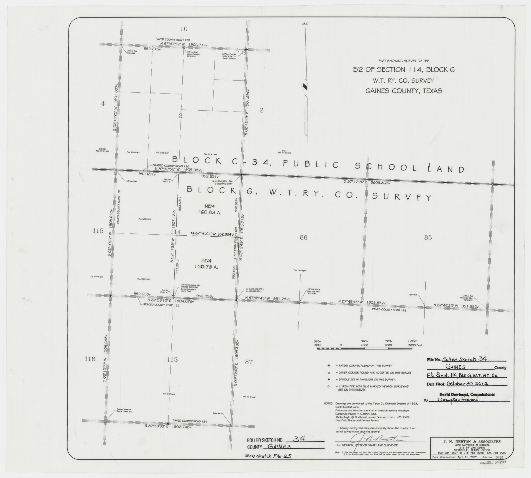
Gaines County Rolled Sketch 34
Plat showing survey of the E/2 of section 114, Block G, W. T. R.R. Co. survey
-
Map/Doc
77533
-
Collection
General Map Collection
-
Object Dates
2002/4/11 (Creation Date)
2002/10/30 (File Date)
-
People and Organizations
J.N. Newton (Surveyor/Engineer)
-
Counties
Gaines
-
Subjects
Surveying Rolled Sketch
-
Height x Width
20.1 x 22.3 inches
51.1 x 56.6 cm
-
Medium
mylar, print
-
Comments
See Gaines County Sketch File 25 (82618) for report.
Related maps
Gaines County Sketch File 25

Print $4.00
- Digital $50.00
Gaines County Sketch File 25
2002
Size 11.0 x 8.5 inches
Map/Doc 82618
Part of: General Map Collection
Coleman County

Print $20.00
- Digital $50.00
Coleman County
1862
Size 22.5 x 21.6 inches
Map/Doc 3414
Lampasas River, City of Lampasas, Lampasas Sheet/Sulphur & Burleson Creeks

Print $20.00
- Digital $50.00
Lampasas River, City of Lampasas, Lampasas Sheet/Sulphur & Burleson Creeks
1937
Size 33.4 x 19.3 inches
Map/Doc 16956
Garza County Sketch File 7

Print $4.00
- Digital $50.00
Garza County Sketch File 7
1900
Size 13.3 x 8.5 inches
Map/Doc 24060
Oldham County Rolled Sketch 2

Print $40.00
- Digital $50.00
Oldham County Rolled Sketch 2
1886
Size 35.7 x 55.1 inches
Map/Doc 9639

Hood County Sketch File 19

Print $11.00
- Digital $50.00
Hood County Sketch File 19
Size 9.0 x 7.9 inches
Map/Doc 26603
Gregg County Boundary File 2

Print $8.00
- Digital $50.00
Gregg County Boundary File 2
Size 8.8 x 3.7 inches
Map/Doc 53984
Van Zandt County Sketch File 33

Print $8.00
- Digital $50.00
Van Zandt County Sketch File 33
1860
Size 12.4 x 7.8 inches
Map/Doc 39469
[Sketch for Mineral Application 16777]
![65654, [Sketch for Mineral Application 16777], General Map Collection](https://historictexasmaps.com/wmedia_w700/maps/65654-1.tif.jpg)
Print $40.00
- Digital $50.00
[Sketch for Mineral Application 16777]
Size 80.1 x 19.7 inches
Map/Doc 65654
Mississippi River to Galveston

Print $40.00
- Digital $50.00
Mississippi River to Galveston
1976
Size 37.4 x 51.2 inches
Map/Doc 69947
Edwards County Working Sketch 49

Print $20.00
- Digital $50.00
Edwards County Working Sketch 49
1950
Size 23.6 x 28.1 inches
Map/Doc 68925
Parker County Working Sketch 19-2

Print $20.00
- Digital $50.00
Parker County Working Sketch 19-2
2005
Map/Doc 83580
You may also like
Nine Central Panhandle Counties, Texas

Print $20.00
- Digital $50.00
Nine Central Panhandle Counties, Texas
1899
Size 41.3 x 35.3 inches
Map/Doc 89790
University of Texas System University Lands

Print $20.00
- Digital $50.00
University of Texas System University Lands
Size 23.1 x 17.5 inches
Map/Doc 93238
Kleberg County Aerial Photograph Index Sheet 1

Print $20.00
- Digital $50.00
Kleberg County Aerial Photograph Index Sheet 1
1956
Size 19.6 x 23.6 inches
Map/Doc 83718
Jim Wells County Working Sketch 3

Print $20.00
- Digital $50.00
Jim Wells County Working Sketch 3
1936
Size 27.7 x 24.5 inches
Map/Doc 66601
Jasper County Working Sketch 19

Print $20.00
- Digital $50.00
Jasper County Working Sketch 19
1939
Size 15.8 x 15.8 inches
Map/Doc 66481
Motley County Sketch File 17 (N)

Print $4.00
- Digital $50.00
Motley County Sketch File 17 (N)
1913
Size 8.7 x 7.8 inches
Map/Doc 32060
Winkler County Rolled Sketch CE-1

Print $20.00
- Digital $50.00
Winkler County Rolled Sketch CE-1
1936
Size 36.8 x 35.5 inches
Map/Doc 10149
Bell County Sketch File 26

Print $14.00
- Digital $50.00
Bell County Sketch File 26
1886
Size 14.2 x 8.8 inches
Map/Doc 14426
Coleman County

Print $40.00
- Digital $50.00
Coleman County
1945
Size 54.7 x 37.1 inches
Map/Doc 73109
The Santa Fe Route and connections

Print $20.00
The Santa Fe Route and connections
1888
Size 15.4 x 24.8 inches
Map/Doc 96972
Real County Working Sketch 63

Print $20.00
- Digital $50.00
Real County Working Sketch 63
1967
Size 28.8 x 32.3 inches
Map/Doc 71955
[Cotton Belt, St. Louis Southwestern Railway of Texas, Alignment through Smith County]
![64374, [Cotton Belt, St. Louis Southwestern Railway of Texas, Alignment through Smith County], General Map Collection](https://historictexasmaps.com/wmedia_w700/maps/64374.tif.jpg)
Print $20.00
- Digital $50.00
[Cotton Belt, St. Louis Southwestern Railway of Texas, Alignment through Smith County]
1903
Size 21.5 x 29.3 inches
Map/Doc 64374