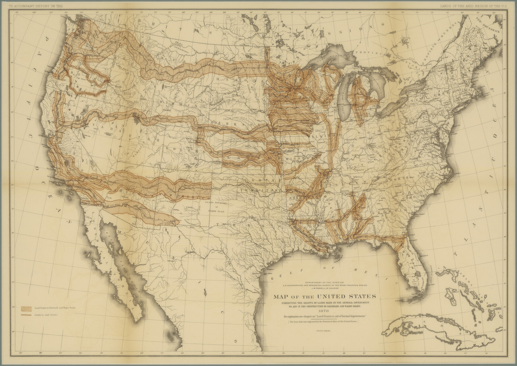
Map of the United States Exhibiting the grants of lands made by the general government to aid in the construction of railroads and wagon roads
-
Map/Doc
95286
-
Collection
Non-GLO Digital Images
-
Object Dates
1878 (Creation Date)
-
People and Organizations
Department of the Interior (Publisher)
Julius Bien (Printer)
John Wesley Powell (Author)
-
Subjects
Railroads United States
-
Height x Width
20.8 x 29.4 inches
52.8 x 74.7 cm
-
Medium
digital image
-
Comments
Digital image courtesy of an anonymous supporter of the Texas General Land Office in 2018.
Part of: Non-GLO Digital Images
Plano, Collin County, Texas

Print $20.00
Plano, Collin County, Texas
1891
Size 12.8 x 22.6 inches
Map/Doc 93758
Plan of the City of Washington the Capitol of the United States of America

Print $20.00
- Digital $50.00
Plan of the City of Washington the Capitol of the United States of America
1863
Size 12.7 x 15.8 inches
Map/Doc 94475
Map of South Eastern Washington Territory

Print $20.00
Map of South Eastern Washington Territory
1878
Size 31.3 x 41.1 inches
Map/Doc 93942

Oldham County Surveyor's Oath of Office

Print $3.00
Oldham County Surveyor's Oath of Office
1881
Size 15.2 x 9.7 inches
Map/Doc 47716
Fort Worth, Tex. "The Queen of the Prairies," County Seat of Tarrant County

Print $20.00
Fort Worth, Tex. "The Queen of the Prairies," County Seat of Tarrant County
1886
Size 26.0 x 33.3 inches
Map/Doc 89082
Clarendon, Texas, Donley Co.

Print $20.00
Clarendon, Texas, Donley Co.
1890
Size 15.7 x 26.6 inches
Map/Doc 89078
Ladonia, Fannin County, Texas

Print $20.00
Ladonia, Fannin County, Texas
1891
Size 12.0 x 22.1 inches
Map/Doc 89097

Outline of the Geology of the Globe

Print $20.00
Outline of the Geology of the Globe
1853
Size 19.3 x 23.6 inches
Map/Doc 95282

[WWI Topographic Planning Map of the Ardennes]
![94129, [WWI Topographic Planning Map of the Ardennes], Non-GLO Digital Images](https://historictexasmaps.com/wmedia_w700/maps/94129-1.tif.jpg)
Print $20.00
[WWI Topographic Planning Map of the Ardennes]
1918
Size 35.8 x 20.2 inches
Map/Doc 94129
You may also like
Fractional Township No. 8 South Range No. 14 East of the Indian Meridian, Indian Territory

Print $20.00
- Digital $50.00
Fractional Township No. 8 South Range No. 14 East of the Indian Meridian, Indian Territory
1896
Size 19.2 x 24.3 inches
Map/Doc 75225
[Sketch of part of G. & M. Block 5]
![93073, [Sketch of part of G. & M. Block 5], Twichell Survey Records](https://historictexasmaps.com/wmedia_w700/maps/93073-1.tif.jpg)
Print $2.00
- Digital $50.00
[Sketch of part of G. & M. Block 5]
Size 6.7 x 8.7 inches
Map/Doc 93073
Hill County Boundary File 1

Print $20.00
- Digital $50.00
Hill County Boundary File 1
Size 12.8 x 8.3 inches
Map/Doc 54722
Flight Mission No. CUG-2P, Frame 26, Kleberg County

Print $20.00
- Digital $50.00
Flight Mission No. CUG-2P, Frame 26, Kleberg County
1956
Size 18.7 x 22.4 inches
Map/Doc 86190
The United States of America

Print $20.00
- Digital $50.00
The United States of America
1866
Size 21.3 x 18.3 inches
Map/Doc 72646
Menard County Sketch File 3

Print $40.00
- Digital $50.00
Menard County Sketch File 3
Size 16.3 x 12.9 inches
Map/Doc 31488
Flight Mission No. DCL-4C, Frame 146, Kenedy County

Print $20.00
- Digital $50.00
Flight Mission No. DCL-4C, Frame 146, Kenedy County
1943
Size 18.6 x 22.3 inches
Map/Doc 85824
Wharton County Sketch File 6

Print $4.00
- Digital $50.00
Wharton County Sketch File 6
1877
Size 8.6 x 14.2 inches
Map/Doc 39923
Flight Mission No. DAG-14K, Frame 131, Matagorda County

Print $20.00
- Digital $50.00
Flight Mission No. DAG-14K, Frame 131, Matagorda County
1952
Size 18.5 x 22.3 inches
Map/Doc 86302

Bailey County Sketch File 21

Print $14.00
- Digital $50.00
Bailey County Sketch File 21
Size 11.3 x 8.8 inches
Map/Doc 13990