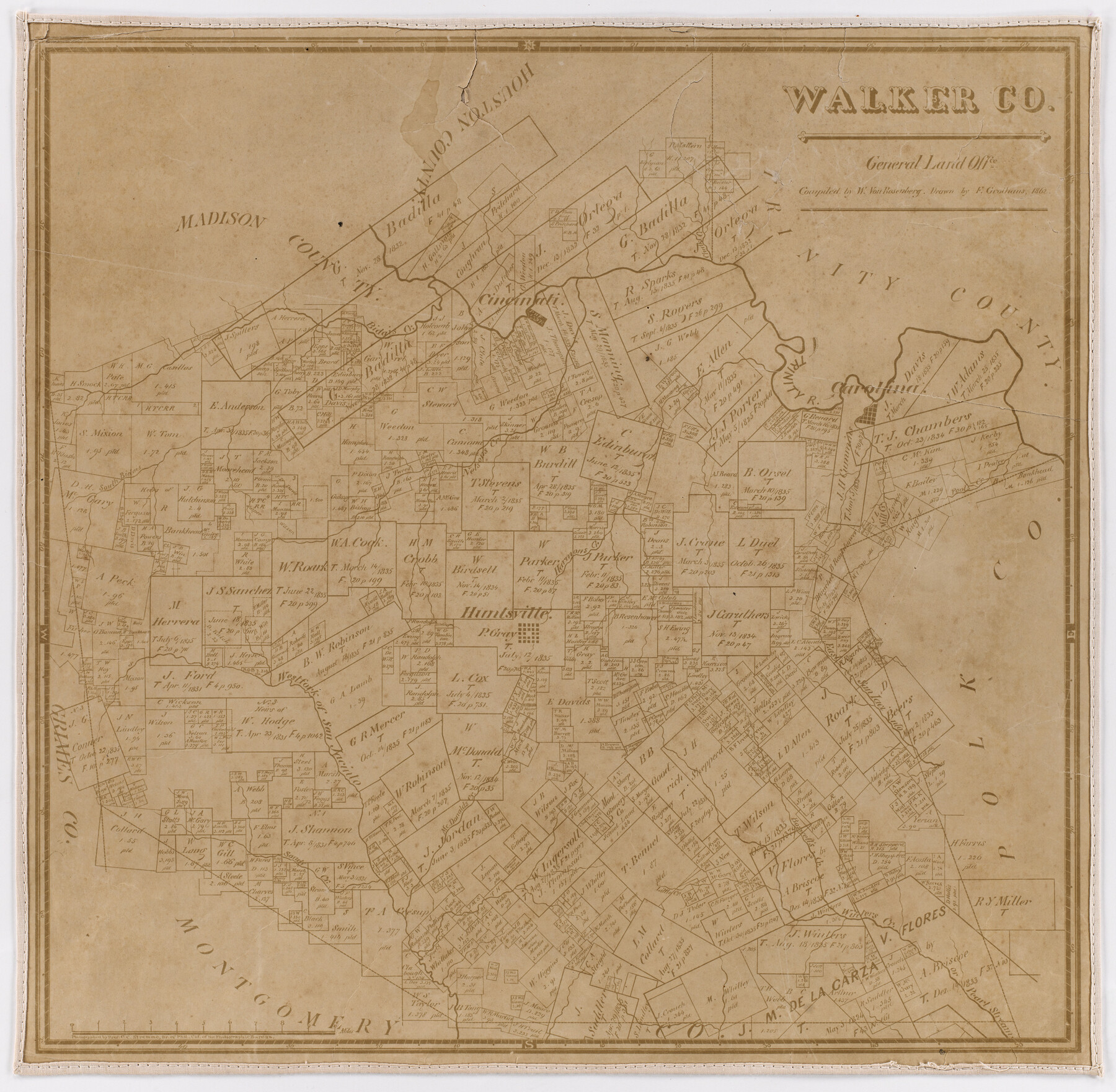
Walker Co.
- 
                          Map/Doc
93977
 - 
                            Collection
Non-GLO Digital Images
 - 
                            Object Dates
1862 (Creation Date)
 - 
                            People and Organizations
W. von Rosenberg (Compiler)
F. Grothaus (Draftsman)
 - 
                            Subjects
County
 - 
                            Height x Width
19.3 x 19.7 inches
49.0 x 50.0 cm
 - 
                            Comments
Digital image obtained from the Dolph Briscoe Center for American History at UT. Presented for research only as an example of a county map produced by the GLO Photographic Bureau.
 
Part of: Non-GLO Digital Images
            A Geological Map of the United States and Canada


                                            Print $20.00                    
                                    
                A Geological Map of the United States and Canada
1853
Size 17.4 x 25.0 inches
                                Map/Doc 95189
            
            Map of the State of Texas Engraved to Illustrate Mitchell's School and Family Geography


                                            Print $20.00                    
                                    
                Map of the State of Texas Engraved to Illustrate Mitchell's School and Family Geography
1846
Size 12.0 x 9.6 inches
                                Map/Doc 87902
            
            Plano del Presidio de Nra. Senora del Pilar de los Adaes, Capital de la Provincia de los Tejas situado en 32 grados y 15 minutos de Latitud Boreal, y en 285° y 52' de Longitud respecto del Meridiano de Tenerife


            Plano del Presidio de Nra. Senora del Pilar de los Adaes, Capital de la Provincia de los Tejas situado en 32 grados y 15 minutos de Latitud Boreal, y en 285° y 52' de Longitud respecto del Meridiano de Tenerife
Size 16.9 x 21.4 inches
                                Map/Doc 96563
            
            The Official Map of the City of El Paso, State of Texas


                                            Print $20.00                    
                                    
                The Official Map of the City of El Paso, State of Texas
1889
Size 42.4 x 54.4 inches
                                Map/Doc 89617
            
            Bird's Eye View of McKinney, County Seat of Collin Co[unty], Texas


                                            Print $20.00                    
                                    
                Bird's Eye View of McKinney, County Seat of Collin Co[unty], Texas
1876
Size 11.7 x 14.7 inches
                                Map/Doc 89099
            
            Map of Texas with Parts of the Adjoining States


                                            Print $20.00                    
                                    
                Map of Texas with Parts of the Adjoining States
1836
Size 29.8 x 24.1 inches
                                Map/Doc 93963
            
            Fort Worth, Tex. "The Queen of the Prairies," County Seat of Tarrant County


                                            Print $20.00                    
                                    
                Fort Worth, Tex. "The Queen of the Prairies," County Seat of Tarrant County
1886
Size 26.0 x 33.3 inches
                                Map/Doc 89082
            
            Carta Particular de las Costas Setentrionales del Seno Mexicano que comprehende las de la Florída Ocidental las Márgenes de la Luisiana y toda la rivera que sigue por la Bahía de S. Bernardo y el Rio Bravo del Norte hasta la Laguna Madre


            Carta Particular de las Costas Setentrionales del Seno Mexicano que comprehende las de la Florída Ocidental las Márgenes de la Luisiana y toda la rivera que sigue por la Bahía de S. Bernardo y el Rio Bravo del Norte hasta la Laguna Madre
1807
Size 27.3 x 40.3 inches
                                Map/Doc 94565
            
            Map of Texas and the Countries Adjacent


            Map of Texas and the Countries Adjacent
1844
Size 19.0 x 29.6 inches
                                Map/Doc 94561
            
            Mapa de Texas con partes de los Estados Adyacentes


            Mapa de Texas con partes de los Estados Adyacentes
1832
Size 6.8 x 5.7 inches
                                Map/Doc 94560
            
            Bird's Eye View of Schulenburg, Fayette County, Texas


                                            Print $20.00                    
                                    
                Bird's Eye View of Schulenburg, Fayette County, Texas
1881
Size 18.6 x 31.0 inches
                                Map/Doc 89206
            You may also like
            Liberty County Working Sketch 83


                                            Print $40.00                    
                                             -                         Digital $50.00                                    
                Liberty County Working Sketch 83
1981
Size 68.4 x 37.8 inches
                                Map/Doc 70543
            
            Travis County State Real Property Sketch 3


                                            Print $20.00                    
                                             -                         Digital $50.00                                    
                Travis County State Real Property Sketch 3
1985
Size 34.3 x 35.9 inches
                                Map/Doc 61694
            
            Real County Working Sketch 10


                                            Print $20.00                    
                                             -                         Digital $50.00                                    
                Real County Working Sketch 10
1929
Size 23.0 x 15.4 inches
                                Map/Doc 71902
            
            Dimmit County Rolled Sketch 21


                                            Print $20.00                    
                                             -                         Digital $50.00                                    
                Dimmit County Rolled Sketch 21
2013
Size 25.5 x 22.5 inches
                                Map/Doc 93488
            
            Calhoun County NRC Article 33.136 Sketch 6


                                            Print $24.00                    
                                             -                         Digital $50.00                                    
                Calhoun County NRC Article 33.136 Sketch 6
2014
Size 18.0 x 24.0 inches
                                Map/Doc 94462
            
            Wood County Boundary File 97


                                            Print $2.00                    
                                             -                         Digital $50.00                                    
                Wood County Boundary File 97
Size 9.4 x 4.5 inches
                                Map/Doc 60195
            
            Flight Mission No. CGI-4N, Frame 176, Cameron County


                                            Print $20.00                    
                                             -                         Digital $50.00                                    
                Flight Mission No. CGI-4N, Frame 176, Cameron County
1955
Size 18.5 x 22.2 inches
                                Map/Doc 84679
            
            Flight Mission No. DIX-5P, Frame 112, Aransas County


                                            Print $20.00                    
                                             -                         Digital $50.00                                    
                Flight Mission No. DIX-5P, Frame 112, Aransas County
1956
Size 17.9 x 18.0 inches
                                Map/Doc 83791
            
            Topography and water depth as shown by the U.S. Coast Survey of 1888


                                            Print $20.00                    
                                             -                         Digital $50.00                                    
                Topography and water depth as shown by the U.S. Coast Survey of 1888
1890
Size 17.0 x 18.8 inches
                                Map/Doc 390
            
            Coryell County Working Sketch 24


                                            Print $20.00                    
                                             -                         Digital $50.00                                    
                Coryell County Working Sketch 24
1979
Size 35.5 x 34.5 inches
                                Map/Doc 68231
            
            Hardin County Rolled Sketch 11


                                            Print $20.00                    
                                             -                         Digital $50.00                                    
                Hardin County Rolled Sketch 11
1948
Size 20.8 x 38.6 inches
                                Map/Doc 6083
            
            County Map of the Pan-Handle of Texas and the line of the Texas Pan-Handle Route


                                            Print $20.00                    
                                             -                         Digital $50.00                                    
                County Map of the Pan-Handle of Texas and the line of the Texas Pan-Handle Route
1900
Size 7.2 x 10.3 inches
                                Map/Doc 95888