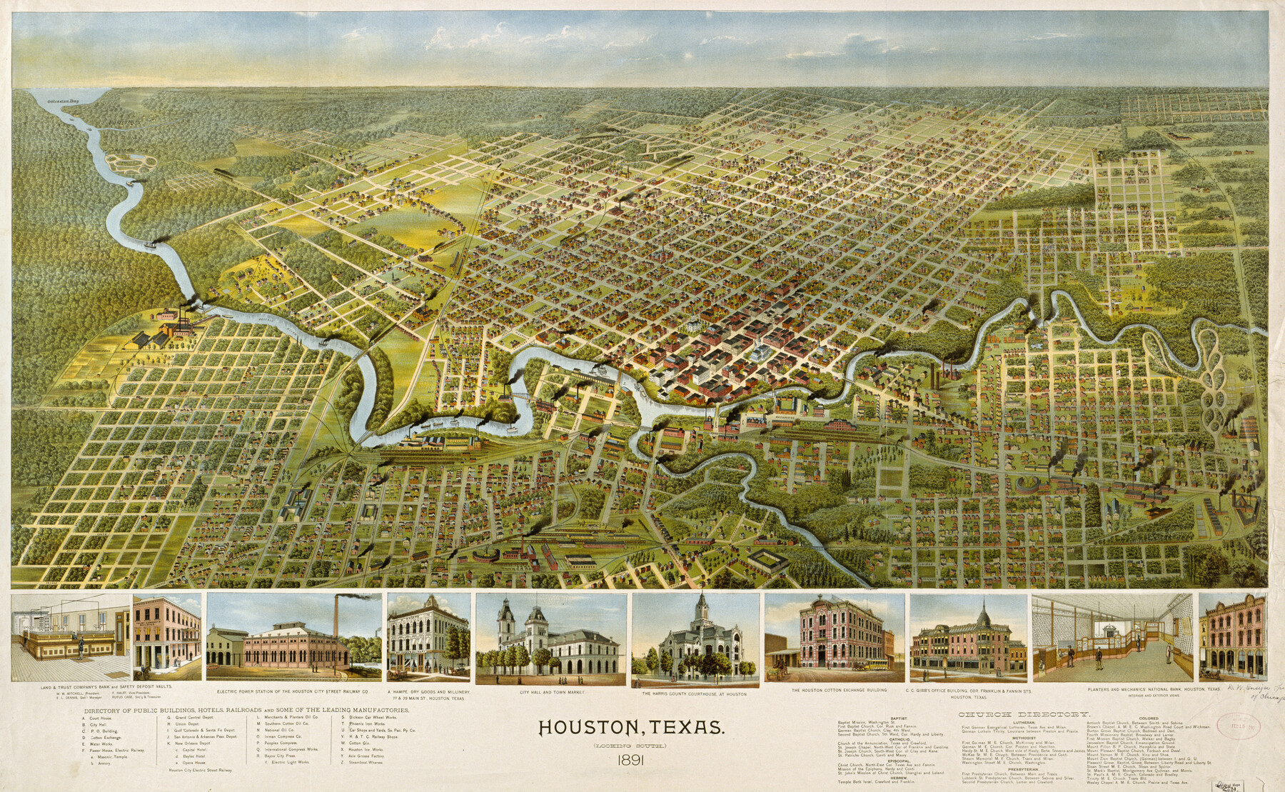
Houston, Texas (Looking South)
-
Map/Doc
89094
-
Collection
Non-GLO Digital Images
-
Object Dates
1891 (Creation Date)
-
People and Organizations
[A.L. Westyard] (Draftsman)
-
Counties
Harris
-
Subjects
Bird's Eye View City Pictorial
-
Height x Width
25.3 x 41.1 inches
64.3 x 104.4 cm
-
Comments
Bird's Eye View map. Public Domain image obtained from Wikimedia Commons. See map# 93465 for another copy of this map.
Related maps
Houston, Texas (Looking South)

Print $20.00
Houston, Texas (Looking South)
1891
Size 41.1 x 25.3 inches
Map/Doc 93465
Part of: Non-GLO Digital Images
Austin, State Capital of Texas

Print $20.00
Austin, State Capital of Texas
1887
Size 27.5 x 40.0 inches
Map/Doc 89218
Map of North America engraved to illustrate Mitchell's school and family geography

Print $20.00
Map of North America engraved to illustrate Mitchell's school and family geography
1839
Size 11.3 x 8.7 inches
Map/Doc 93552
Bird's Eye View of Bastrop, Bastrop County, Texas

Print $20.00
Bird's Eye View of Bastrop, Bastrop County, Texas
1887
Size 18.8 x 25.7 inches
Map/Doc 89073
[1/4 of a WWI French map of Attigny used by the 142nd Infantry for planning purposes for the Battle of Forest Ferme (farm)]
![96642, [1/4 of a WWI French map of Attigny used by the 142nd Infantry for planning purposes for the Battle of Forest Ferme (farm)], Non-GLO Digital Images](https://historictexasmaps.com/wmedia_w700/maps/96642.tif.jpg)
Print $20.00
[1/4 of a WWI French map of Attigny used by the 142nd Infantry for planning purposes for the Battle of Forest Ferme (farm)]
1918
Size 21.1 x 17.7 inches
Map/Doc 96642

El Nuevo México y Tierras Adyacentes Levantado para la Demarcación de los Límites de los Dominios Españoles y de los Estados Unidos

El Nuevo México y Tierras Adyacentes Levantado para la Demarcación de los Límites de los Dominios Españoles y de los Estados Unidos
1811
Size 9.4 x 12.6 inches
Map/Doc 94445


Bird's Eye View of Gatesville, Coryell County, Texas

Print $20.00
Bird's Eye View of Gatesville, Coryell County, Texas
1884
Size 15.7 x 24.2 inches
Map/Doc 89088
Plano del Presidio de Nra. Senora del Pilar de los Adaes, Capital de la Provincia de los Tejas situado en 32 grados y 15 minutos de Latitud Boreal, y en 285° y 52' de Longitud respecto del Meridiano de Tenerife

Plano del Presidio de Nra. Senora del Pilar de los Adaes, Capital de la Provincia de los Tejas situado en 32 grados y 15 minutos de Latitud Boreal, y en 285° y 52' de Longitud respecto del Meridiano de Tenerife
Size 16.9 x 21.4 inches
Map/Doc 96563
Bird's Eye View of La Grange, Fayette County, Texas

Print $20.00
Bird's Eye View of La Grange, Fayette County, Texas
1880
Size 24.1 x 31.2 inches
Map/Doc 89096
Bird's Eye View of New Braunfels, Comal County, Texas

Print $20.00
Bird's Eye View of New Braunfels, Comal County, Texas
1881
Size 17.0 x 24.1 inches
Map/Doc 89200
You may also like
Northern Mexico Campaign of the U.S. - Mexico War

Northern Mexico Campaign of the U.S. - Mexico War
2023
Size 8.5 x 11.0 inches
Map/Doc 97152
Working Sketch in Stephens County

Print $20.00
- Digital $50.00
Working Sketch in Stephens County
1919
Size 11.1 x 20.6 inches
Map/Doc 91903
Concho County

Print $20.00
- Digital $50.00
Concho County
1897
Size 45.9 x 38.0 inches
Map/Doc 66785
El Paso County Boundary File 6

Print $14.00
- Digital $50.00
El Paso County Boundary File 6
Size 14.0 x 8.8 inches
Map/Doc 53080
Amistad International Reservoir on Rio Grande 81

Print $20.00
- Digital $50.00
Amistad International Reservoir on Rio Grande 81
1949
Size 28.6 x 40.2 inches
Map/Doc 75510
Tarrant's Key and Guide to Dallas

Print $20.00
- Digital $50.00
Tarrant's Key and Guide to Dallas
1922
Size 28.1 x 23.2 inches
Map/Doc 89256
Flight Mission No. DCL-6C, Frame 14, Kenedy County

Print $20.00
- Digital $50.00
Flight Mission No. DCL-6C, Frame 14, Kenedy County
1943
Size 18.7 x 22.4 inches
Map/Doc 85871
Coleman County Sketch File 3a

Print $20.00
- Digital $50.00
Coleman County Sketch File 3a
1857
Size 12.6 x 19.2 inches
Map/Doc 11117
Stephens County Sketch File 12

Print $8.00
- Digital $50.00
Stephens County Sketch File 12
1884
Size 10.8 x 8.3 inches
Map/Doc 37057


Railroad and County Map of Texas

Print $20.00
- Digital $50.00
Railroad and County Map of Texas
1908
Size 42.7 x 44.7 inches
Map/Doc 2141