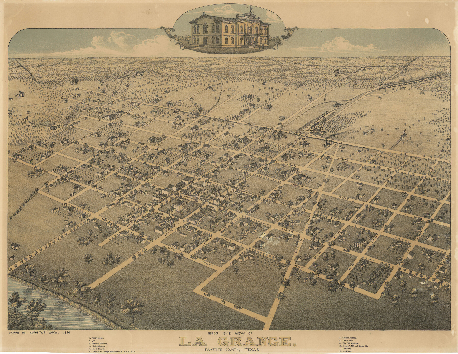
Bird's Eye View of La Grange, Fayette County, Texas
-
Map/Doc
89096
-
Collection
Non-GLO Digital Images
-
Object Dates
1880 (Creation Date)
-
People and Organizations
Augustus Koch (Draftsman)
-
Counties
Fayette
-
Subjects
Bird's Eye View City Pictorial
-
Height x Width
24.1 x 31.2 inches
61.2 x 79.3 cm
-
Comments
Bird's Eye View map. Public Domain image obtained from Wikimedia Commons.
Part of: Non-GLO Digital Images
Preliminary Survey of the Entrance to the Rio Grande, Texas

Print $20.00
Preliminary Survey of the Entrance to the Rio Grande, Texas
1854
Size 14.2 x 14.9 inches
Map/Doc 95283
Seymour, Baylor County, Texas

Print $20.00
Seymour, Baylor County, Texas
1890
Size 15.4 x 24.2 inches
Map/Doc 89207
[Movements & Objectives of the 143rd & 144th Infantry & 133rd Machine Gun Battalion on October 8-9, 1918, Appendix E, No. 4] - Verso
![94134, [Movements & Objectives of the 143rd & 144th Infantry & 133rd Machine Gun Battalion on October 8-9, 1918, Appendix E, No. 4] - Verso, Non-GLO Digital Images](https://historictexasmaps.com/wmedia_w700/maps/94134-1.tif.jpg)
Print $20.00
[Movements & Objectives of the 143rd & 144th Infantry & 133rd Machine Gun Battalion on October 8-9, 1918, Appendix E, No. 4] - Verso
1918
Size 21.5 x 20.0 inches
Map/Doc 94134
Bird's Eye View of the City of Austin, Travis County, Texas

Print $20.00
Bird's Eye View of the City of Austin, Travis County, Texas
1873
Size 21.3 x 28.7 inches
Map/Doc 89217
Engineer map showing engineer information at 23 O'Clock 23 Oct. 1918 drawn under direction of Col. W.A. Mitchell

Print $20.00
Engineer map showing engineer information at 23 O'Clock 23 Oct. 1918 drawn under direction of Col. W.A. Mitchell
1918
Size 19.6 x 12.5 inches
Map/Doc 94127
Bird's Eye View of Corpus Christi

Print $20.00
Bird's Eye View of Corpus Christi
1887
Size 21.4 x 28.0 inches
Map/Doc 94113
[Movements & Objectives of the 143rd & 144th Infantry on October 9-11, 1918, Appendix E, Nos.2 and 3]
![94131, [Movements & Objectives of the 143rd & 144th Infantry on October 9-11, 1918, Appendix E, Nos.2 and 3], Non-GLO Digital Images](https://historictexasmaps.com/wmedia_w700/maps/94131-1.tif.jpg)
Print $20.00
[Movements & Objectives of the 143rd & 144th Infantry on October 9-11, 1918, Appendix E, Nos.2 and 3]
1918
Size 41.6 x 19.9 inches
Map/Doc 94131
Plan of New Orleans

Print $20.00
- Digital $50.00
Plan of New Orleans
1860
Size 12.8 x 15.7 inches
Map/Doc 95910
[1/4 of a WWI French map of Attigny used by the 142nd Infantry for planning purposes for the Battle of Forest Ferme (farm)]
![96642, [1/4 of a WWI French map of Attigny used by the 142nd Infantry for planning purposes for the Battle of Forest Ferme (farm)], Non-GLO Digital Images](https://historictexasmaps.com/wmedia_w700/maps/96642.tif.jpg)
Print $20.00
[1/4 of a WWI French map of Attigny used by the 142nd Infantry for planning purposes for the Battle of Forest Ferme (farm)]
1918
Size 21.1 x 17.7 inches
Map/Doc 96642
Carta Particular de las Costas Setentrionales del Seno Mexicano que comprehende las de la Florida Ocidental las Margenes de la Luisiana y toda la rivera que sigue por la Bahía de San Bernardo y el Río Bravo del Norte hasta la Laguna Madre

Carta Particular de las Costas Setentrionales del Seno Mexicano que comprehende las de la Florida Ocidental las Margenes de la Luisiana y toda la rivera que sigue por la Bahía de San Bernardo y el Río Bravo del Norte hasta la Laguna Madre
1825
Size 26.1 x 38.7 inches
Map/Doc 94568


You may also like
Roberts County Working Sketch 38

Print $20.00
- Digital $50.00
Roberts County Working Sketch 38
1978
Size 26.7 x 22.5 inches
Map/Doc 63564
Maverick County Rolled Sketch 19

Print $20.00
- Digital $50.00
Maverick County Rolled Sketch 19
1955
Size 33.5 x 44.1 inches
Map/Doc 9494
Kinney County Rolled Sketch 21

Print $40.00
- Digital $50.00
Kinney County Rolled Sketch 21
1992
Size 39.2 x 57.2 inches
Map/Doc 9358
Map of Survey 9, Block 1, D.B. Gardner

Print $20.00
- Digital $50.00
Map of Survey 9, Block 1, D.B. Gardner
1915
Size 14.0 x 19.0 inches
Map/Doc 415
Roberts County Working Sketch Graphic Index

Print $20.00
- Digital $50.00
Roberts County Working Sketch Graphic Index
1932
Size 41.2 x 37.3 inches
Map/Doc 76684
Matagorda County Rolled Sketch 19

Print $20.00
- Digital $50.00
Matagorda County Rolled Sketch 19
1918
Size 13.0 x 16.6 inches
Map/Doc 6687
[Vicinity of Wilson Strickland Survey]
![91379, [Vicinity of Wilson Strickland Survey], Twichell Survey Records](https://historictexasmaps.com/wmedia_w700/maps/91379-1.tif.jpg)
Print $20.00
- Digital $50.00
[Vicinity of Wilson Strickland Survey]
Size 35.9 x 33.3 inches
Map/Doc 91379
Henderson County Working Sketch 44

Print $20.00
- Digital $50.00
Henderson County Working Sketch 44
1998
Size 19.0 x 33.0 inches
Map/Doc 66177
Map of Bexar County

Print $40.00
- Digital $50.00
Map of Bexar County
1845
Size 90.6 x 81.0 inches
Map/Doc 82242
[Sketch for Mineral Application 24072, San Jacinto River]
![65607, [Sketch for Mineral Application 24072, San Jacinto River], General Map Collection](https://historictexasmaps.com/wmedia_w700/maps/65607.tif.jpg)
Print $20.00
- Digital $50.00
[Sketch for Mineral Application 24072, San Jacinto River]
1929
Size 23.3 x 17.8 inches
Map/Doc 65607
Orange County Sketch File 28

Print $4.00
- Digital $50.00
Orange County Sketch File 28
1922
Size 11.3 x 8.7 inches
Map/Doc 33356
Duval County Sketch File 19b

Print $6.00
- Digital $50.00
Duval County Sketch File 19b
Size 15.4 x 9.7 inches
Map/Doc 21320