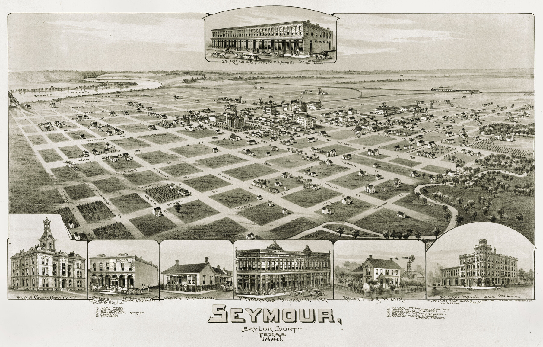
Seymour, Baylor County, Texas
-
Map/Doc
89207
-
Collection
Non-GLO Digital Images
-
Object Dates
1890 (Creation Date)
-
People and Organizations
Thaddeus Mortimer Fowler (Draftsman)
-
Counties
Baylor
-
Subjects
Bird's Eye View City Pictorial
-
Height x Width
15.4 x 24.2 inches
39.1 x 61.5 cm
-
Comments
Bird's Eye View map. Public Domain image obtained from Wikimedia Commons.
Part of: Non-GLO Digital Images
Bird's Eye View of the City of Brenham, Washington County, Texas

Print $20.00
Bird's Eye View of the City of Brenham, Washington County, Texas
1881
Size 19.4 x 26.7 inches
Map/Doc 89076

Outline of the Geology of the Globe

Print $20.00
Outline of the Geology of the Globe
1853
Size 19.3 x 23.6 inches
Map/Doc 95282
Bird's Eye View of Jefferson, Texas

Print $20.00
Bird's Eye View of Jefferson, Texas
1872
Size 18.7 x 23.5 inches
Map/Doc 89095
Seymour, Baylor County, Texas

Print $20.00
Seymour, Baylor County, Texas
1890
Size 15.4 x 24.2 inches
Map/Doc 89207

Map of the State of Texas Engraved to Illustrate Mitchell's School and Family Geography

Print $20.00
Map of the State of Texas Engraved to Illustrate Mitchell's School and Family Geography
1846
Size 12.0 x 9.6 inches
Map/Doc 87902
Kansas Pacific Railway: The Best and Shortest Cattle Route from Texas

Print $20.00
Kansas Pacific Railway: The Best and Shortest Cattle Route from Texas
1872
Size 21.4 x 16.3 inches
Map/Doc 94453
Guadalupe-Blanco River Authority Master Plan

Print $20.00
Guadalupe-Blanco River Authority Master Plan
Size 23.1 x 29.8 inches
Map/Doc 97506
Gulf States and Arkansas

Print $20.00
Gulf States and Arkansas
1874
Size 9.4 x 12.0 inches
Map/Doc 95285
Carta Particular de las Costas Setentrionales del Seno Mexicano que comprehende las de la Florída Ocidental las Márgenes de la Luisiana y toda la rivera que sigue por la Bahía de S. Bernardo y el Rio Bravo del Norte hasta la Laguna Madre

Carta Particular de las Costas Setentrionales del Seno Mexicano que comprehende las de la Florída Ocidental las Márgenes de la Luisiana y toda la rivera que sigue por la Bahía de S. Bernardo y el Rio Bravo del Norte hasta la Laguna Madre
1807
Size 27.3 x 40.3 inches
Map/Doc 94565
Map of the City of Austin

Print $20.00
Map of the City of Austin
1910
Size 24.0 x 18.0 inches
Map/Doc 90071
You may also like
[St. Louis & Southwestern]
![64276, [St. Louis & Southwestern], General Map Collection](https://historictexasmaps.com/wmedia_w700/maps/64276.tif.jpg)
Print $20.00
- Digital $50.00
[St. Louis & Southwestern]
Size 20.9 x 28.7 inches
Map/Doc 64276
Winkler County

Print $20.00
- Digital $50.00
Winkler County
1901
Size 44.1 x 37.9 inches
Map/Doc 63131
Freestone County Rolled Sketch 3

Print $67.00
- Digital $50.00
Freestone County Rolled Sketch 3
Size 10.4 x 15.5 inches
Map/Doc 44784
Liberty County Working Sketch 14

Print $20.00
- Digital $50.00
Liberty County Working Sketch 14
1919
Size 17.0 x 25.4 inches
Map/Doc 70473
Flight Mission No. BRE-1P, Frame 98, Nueces County

Print $20.00
- Digital $50.00
Flight Mission No. BRE-1P, Frame 98, Nueces County
1956
Size 18.4 x 22.1 inches
Map/Doc 86669
A New Map of Texas, Oregon and California with the Regions adjoining

Print $20.00
- Digital $50.00
A New Map of Texas, Oregon and California with the Regions adjoining
1846
Size 20.4 x 19.3 inches
Map/Doc 89067
Gaines County Rolled Sketch 9

Print $20.00
- Digital $50.00
Gaines County Rolled Sketch 9
Size 20.9 x 29.8 inches
Map/Doc 5929
[Map showing resurvey of Capitol Leagues in Hartley & Dallam Counties, Texas]
![1753, [Map showing resurvey of Capitol Leagues in Hartley & Dallam Counties, Texas], General Map Collection](https://historictexasmaps.com/wmedia_w700/maps/1753-1.tif.jpg)
Print $40.00
- Digital $50.00
[Map showing resurvey of Capitol Leagues in Hartley & Dallam Counties, Texas]
1918
Size 66.9 x 31.0 inches
Map/Doc 1753
Orange County Sketch File 14

Print $20.00
- Digital $50.00
Orange County Sketch File 14
Size 19.9 x 32.9 inches
Map/Doc 12118
Bexar County Sketch File 14

Print $4.00
- Digital $50.00
Bexar County Sketch File 14
1855
Size 7.8 x 8.2 inches
Map/Doc 14482
Runnels County Rolled Sketch 31

Print $20.00
- Digital $50.00
Runnels County Rolled Sketch 31
Size 32.4 x 24.1 inches
Map/Doc 7519
Map of Harris County

Print $20.00
- Digital $50.00
Map of Harris County
1893
Size 29.7 x 33.8 inches
Map/Doc 3632